
Ohio and Pennsylvania Storm Update as New Thunderstorms Form in Eastern Ohio and Move Toward Western Pennsylvania With Isolated Tornado Risk Still Possible
EASTERN OHIO — Meteorologists are closely monitoring a new round of discrete thunderstorms forming across eastern Ohio, with radar showing several storm cells beginning to organize and move toward western Pennsylvania. The storms are expected to track eastward during the next hour, potentially affecting communities near Youngstown, Steubenville, and the greater Pittsburgh region as the afternoon progresses.
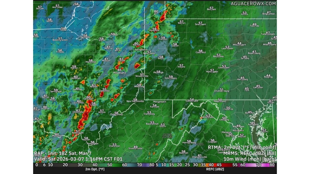
Radar imagery shows a developing cluster of thunderstorms stretching from central Ohio toward eastern Ohio, with additional cells beginning to intensify along a corridor extending from Zanesville through Steubenville and toward Youngstown. These storms are expected to gradually move into western Pennsylvania, including areas near Beaver, Butler, and the outskirts of Pittsburgh.
Discrete Thunderstorms Developing Across Eastern Ohio
Weather radar indicates that multiple individual storm cells are forming rather than a solid storm line, a structure known as discrete storms. This type of storm development can sometimes allow thunderstorms to strengthen individually as they move east.
Several of the strongest storms currently appear near Zanesville, Newark, and eastern portions of Ohio, with lightning-producing cells also forming near Steubenville and areas south of Youngstown. As these storms continue moving eastward, they may gradually organize while crossing the Ohio–Pennsylvania state line.
Meteorologists note that storm movement is generally aligned with southwesterly surface winds, which are pushing storms toward western Pennsylvania and northern West Virginia.
Wind Patterns and Dry Surface Air Influencing Storm Strength
Despite the increasing storm activity, the atmospheric setup suggests that storms may take longer to fully organize into stronger severe thunderstorms.
Surface winds across Ohio and Pennsylvania are currently blowing from the southwest, a pattern described as veered surface winds. While there is still some low-level wind shear present, the wind direction above the surface appears largely unidirectional, meaning winds are moving in roughly the same direction at different heights.
This type of wind structure tends to favor high-based thunderstorms, where the storm’s strongest updrafts are located higher above the ground rather than near the surface.
Additionally, observations show that the air near the surface is slightly drier than expected, likely due to daytime mixing. The wider temperature and dew point spread reduces the amount of surface moisture available to fuel strong storms.
Tornado Threat Lower but Not Completely Eliminated
Because of these atmospheric conditions, meteorologists say the overall tornado threat across eastern Ohio and western Pennsylvania appears somewhat lower than earlier forecasts suggested. However, the risk has not completely disappeared.
A few storms could still become strong enough to produce isolated tornadoes, particularly if they manage to briefly strengthen and tap into pockets of higher instability.
Forecast soundings show that while conditions are not ideal for widespread severe weather, localized storm interactions and temporary increases in instability could allow a couple of storms to briefly rotate.
Residents across Youngstown, Steubenville, Wheeling, Beaver, Butler, and the Pittsburgh metropolitan area should remain alert for rapidly changing weather conditions as storms move through the region.
Storm Activity Expected to Continue Into Western Pennsylvania
As storms continue moving eastward, the primary impacts are expected to include heavy rain, frequent lightning, gusty winds, and localized strong thunderstorm cells. The strongest storms could briefly intensify while crossing from Ohio into Pennsylvania, particularly during the late afternoon hours.
Communities across western Pennsylvania, including Pittsburgh, Butler, Franklin, and Meadville, may see thunderstorms developing or intensifying as the storms approach from the west.
Meteorologists will continue monitoring radar trends and atmospheric conditions to determine whether storms begin organizing into stronger severe cells.
As thunderstorms continue moving from Ohio toward Pennsylvania, ChicagoMusicGuide.com will provide ongoing updates on storm development, radar trends, and potential severe weather across the region.