
Ohio, Indiana, Kentucky, Pennsylvania, and West Virginia Under Slight Risk as Sunday Storm System Targets Areas Along the Ohio River
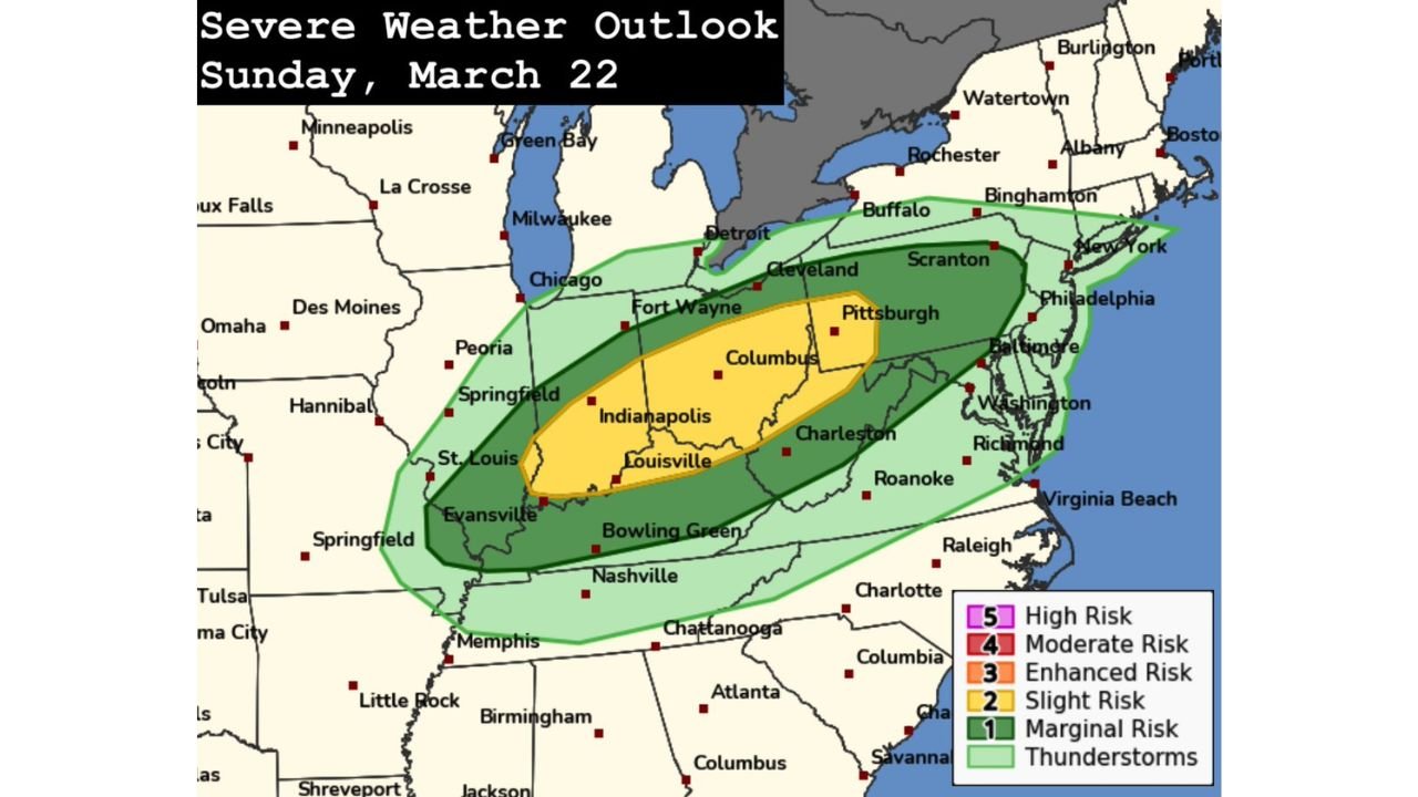
COLUMBUS, OHIO — The Storm Prediction Center (SPC) has outlined a Slight Risk (Level 2 of 5) for severe weather on Sunday, March 22, focusing on areas along and just north of the Ohio River. The highlighted corridor stretches across portions of Indiana, Ohio, Kentucky, western Pennsylvania, and West Virginia, where a developing storm system could bring large hail and damaging winds during the afternoon and evening hours.
Forecasters say a shortwave trough and an advancing surface cold front will move into the region Sunday afternoon, interacting with adequate low-level moisture to trigger thunderstorms. However, atmospheric nuances may limit overall storm intensity.
Cold Front and Shortwave Set the Stage
The approaching system features a mid-level disturbance tracking eastward across the Midwest into the Ohio Valley. As the cold front pushes through Indiana and Ohio and toward Pennsylvania and West Virginia, thunderstorms are expected to develop primarily along the frontal boundary.
Warm temperatures aloft — often referred to as mid-level capping — may confine convection to the front itself, preventing widespread storm coverage. This means storms may form in a relatively narrow band rather than scattered across the broader region.
Cities within the Slight Risk area include Indianapolis, Louisville, Columbus, Pittsburgh, Evansville, Charleston, and Fort Wayne, all positioned within the corridor most likely to see organized storms Sunday afternoon and evening.
Large Hail Early, Damaging Winds Later
If sustained supercells develop along the cold front, forecasters indicate that large hail could occur initially, especially during the early stages of storm development. Strong updrafts along the boundary may briefly support rotating storms capable of producing hailstones large enough to cause localized damage.
As storms mature and begin to merge into clusters or short lines, the primary threat is expected to transition toward damaging straight-line winds. With time, the wind threat may become the dominant hazard as storms congeal and move eastward across the Ohio Valley.
The risk remains conditional on storm development overcoming the cap, but atmospheric parameters suggest at least some organized convection is possible within the highlighted zone.
Tornado Risk Remains Uncertain
The tornado threat appears uncertain at this time. Slightly meager low-level moisture and warm mid-level temperatures may limit instability and low-level rotation potential.
While a brief tornado cannot be completely ruled out if a discrete supercell strengthens, current projections suggest hail and wind pose the more credible concerns across Ohio, Indiana, Kentucky, Pennsylvania, and West Virginia.
Meteorologists will continue monitoring moisture return and frontal timing, as small changes in atmospheric conditions could alter storm intensity.
Timing and Regional Impacts
The most likely window for severe weather appears to be Sunday afternoon into early evening, beginning in Indiana and Kentucky before shifting east into Ohio, western Pennsylvania, and West Virginia.
Communities along the Ohio River corridor should remain weather-aware, especially during late-day outdoor activities. Even with limiting factors in place, storms that do form may briefly intensify and produce impactful conditions.
Residents are encouraged to monitor local forecasts and have multiple ways to receive weather alerts.
As the Ohio Valley prepares for Sunday’s developing storm system, continued updates will refine the severe weather outlook. For ongoing coverage of severe weather alerts, regional forecast analysis, and national storm updates, visit ChicagoMusicGuide.com.