
Ohio, Pennsylvania, West Virginia, Kentucky and Virginia Under Marginal Severe Risk as Cold Front Brings Low-End Tornado Threat to Mid-Upper Ohio Valley
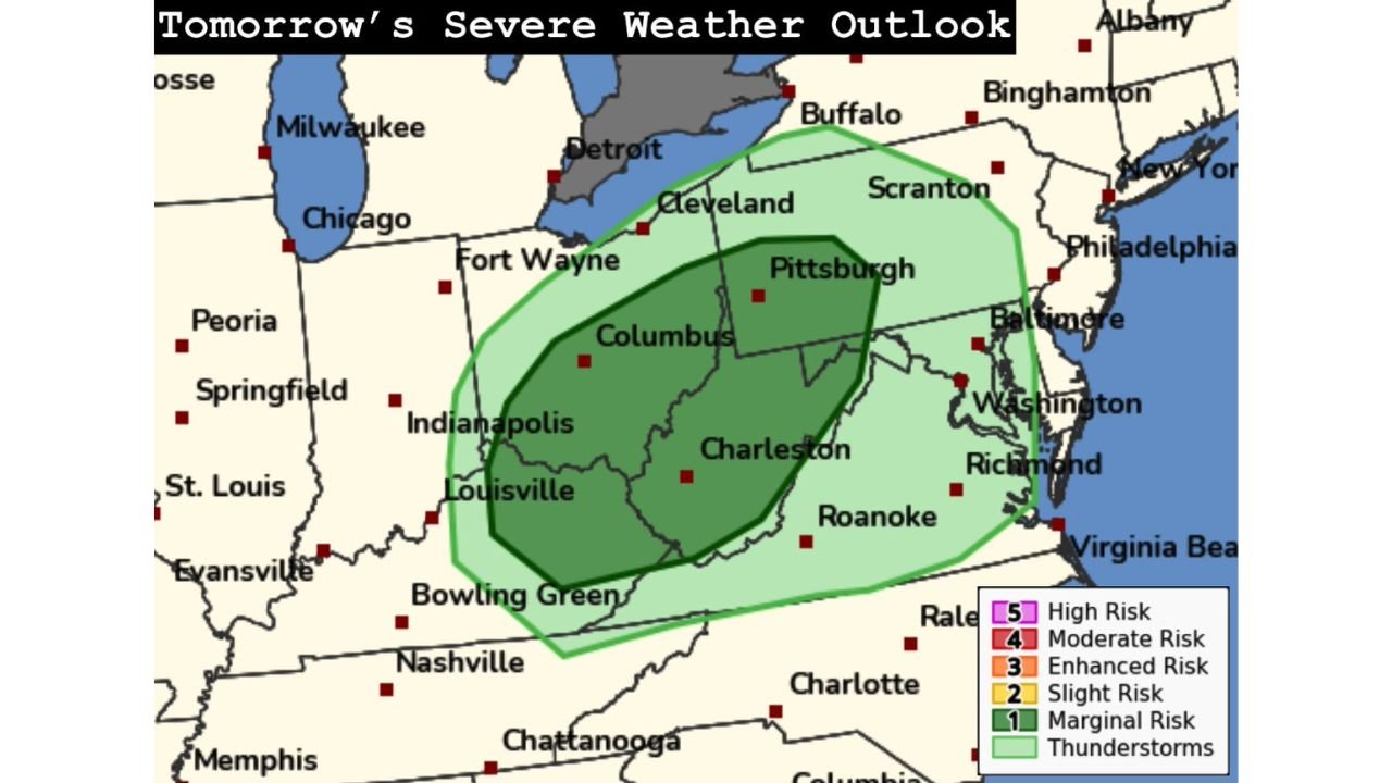
OHIO VALLEY — The Storm Prediction Center has introduced a Level 1 of 5 (Marginal Risk) for severe weather across portions of Ohio, Pennsylvania, West Virginia, Kentucky, and Virginia as a cold front pushes through the region.
While the threat remains low-end, forecasters say just enough moisture may be in place ahead of the front to support isolated severe thunderstorms by tomorrow afternoon.
Marginal Risk Area Covers Key Population Centers
The outlined severe risk zone includes:
- Columbus and Cleveland, Ohio
- Pittsburgh, Pennsylvania
- Much of West Virginia, including Charleston
- Parts of central and eastern Kentucky
- Western and central Virginia
- Portions of western Maryland
Cities near the edge of the risk zone include Louisville, Indianapolis, Richmond, Roanoke, and Washington, D.C., where general thunderstorms are more likely than severe storms.
What “Marginal Risk” Means
A Level 1 Marginal Risk indicates:
- Isolated severe storms possible
- Coverage expected to be limited
- Severe reports likely to be sparse
In this case, forecasters highlight a low-end risk for all hazards, including:
- Gusty, potentially damaging winds
- Small hail
- A brief tornado or two
Any tornado threat would likely be short-lived and embedded within a fast-moving line or isolated cells.
Cold Front Provides Trigger, Moisture is the Question
The setup centers around a cold front sweeping across the mid and upper Ohio Valley. The key ingredients include:
- Modest instability ahead of the boundary
- Limited but sufficient low-level moisture
- Wind shear supportive of organized storms
However, the moisture return appears marginal. If dew points fail to rise enough, storm intensity could remain below severe limits in many areas.
Timing: Afternoon and Early Evening
The most favorable window for stronger storms appears to be:
- Mid-afternoon through early evening
Storms are expected to initiate along or just ahead of the cold front, then move eastward into Pennsylvania and western Virginia by evening.
Because the system is progressive, storms are unlikely to linger in any one location for long.
Tornado Risk Low But Not Zero
Forecasters note that while the overall tornado risk is very low, wind profiles could briefly support rotation in stronger cells.
Any tornado threat would likely be:
- Brief
- Weak
- Highly localized
Residents should not expect a widespread outbreak scenario, but should remain weather-aware if thunderstorms develop in their area.
Chicago and Great Lakes Largely Outside the Risk
Notably, Chicago, Milwaukee, and much of Michigan remain outside the outlined severe risk zone. The primary focus stays south and east of Lake Erie.
Bottom Line
This is not a high-impact severe weather event, but rather a low-end, conditional threat dependent on storm development and moisture availability.
Communities across Ohio, Pennsylvania, West Virginia, Kentucky, and Virginia should monitor forecasts tomorrow afternoon, especially if skies become partly sunny and temperatures climb ahead of the front.
For now, the expectation is for isolated stronger storms — not a major severe weather outbreak.
Stay with ChicagoMusicGuide.com for the latest updates as tomorrow’s storm chances evolve.