
Oklahoma and North Texas Face Conditional Supercell Threat While Missouri, Iowa and Illinois Brace for Damaging Wind Risk Along Advancing Cold Front
UNITED STATES — Friday’s severe weather setup is shaping up to feature two distinct storm regions across the Plains and Mississippi Valley, with one corridor favoring a more certain damaging wind threat and another posing a conditional but potentially significant tornado risk.
Forecast guidance highlights a cold front sweeping eastward from the central Plains, while a separate dryline setup could ignite discrete storms farther south across parts of Oklahoma and North Texas.
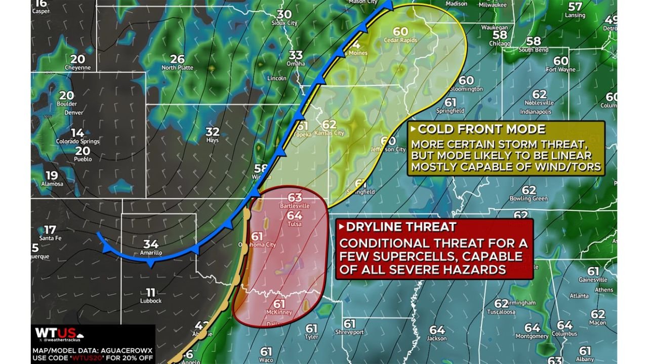
Cold Front Mode: More Certain Storm Coverage From Missouri to Illinois
The more widespread and confident severe setup appears along the advancing cold front, stretching from:
- Eastern Kansas
- Missouri
- Into Iowa
- And toward Illinois, including areas near Chicago
Storms along this boundary are expected to organize in a linear fashion, meaning squall lines or broken lines of storms will likely dominate.
Primary threats in this region include:
- Damaging straight-line winds
- Embedded tornadoes within the line
- Heavy rainfall and lightning
Cities such as Kansas City, Jefferson City, Cedar Rapids, Springfield (MO), Bloomington (IL), and Chicago (IL) sit within the broader zone where storms could track east or northeast.
While tornado potential exists, the overall mode suggests wind will be the primary hazard along this northern corridor.
Dryline Setup: Oklahoma and North Texas Could See Discrete Supercells
Farther south, a separate and more conditional threat zone is highlighted across:
- Oklahoma City
- Tulsa
- Bartlesville
- Down into North Texas, including areas near McKinney and Dallas-Fort Worth
This region sits along a dryline — a sharp boundary separating dry western air from moist Gulf air. Storm development here is less certain, but if storms do initiate and mature, they could become isolated supercells.
Supercells in this environment would be capable of:
- Large hail
- Damaging winds
- Strong tornadoes
- Possibly a few significant severe storms
This makes the southern corridor more volatile — not necessarily widespread, but potentially more intense on a localized level.
Temperature and Instability Setup
Surface temperatures in the 60s across Oklahoma, Missouri, Illinois, and surrounding states suggest sufficient low-level moisture is present. Meanwhile, stronger winds aloft associated with the approaching trough enhance shear profiles favorable for organized storms.
The key question will be storm initiation timing and whether the dryline environment destabilizes enough before the cold front overtakes it.
What This Means for Chicago and the Midwest
Although the highest-end supercell potential is centered farther south in Oklahoma and North Texas, the northern cold front mode includes parts of Illinois and the Chicago metro area within the broader risk envelope.
Even a primarily linear storm system can produce:
- Widespread wind damage
- Power outages
- Quick spin-up tornadoes
Midwest residents should monitor forecast updates as timing and storm evolution become clearer.
Bottom Line
Friday’s severe weather threat splits into two regions:
- A more certain linear wind threat from Kansas through Missouri, Iowa, and into Illinois
- A conditional but higher-end supercell threat across Oklahoma and North Texas
If southern storms remain isolated and mature, all severe hazards — including tornadoes — will be possible. Meanwhile, the northern corridor may see more widespread damaging winds along the advancing cold front.
ChicagoMusicGuide.com will continue tracking this evolving multi-state severe weather setup as confidence increases heading into Friday.