
Oklahoma and Texas See Rapidly Increasing Tornado Threat Near Childress and Elk City as Storm Prediction Center Warns of Strong Storms Within Watch 86
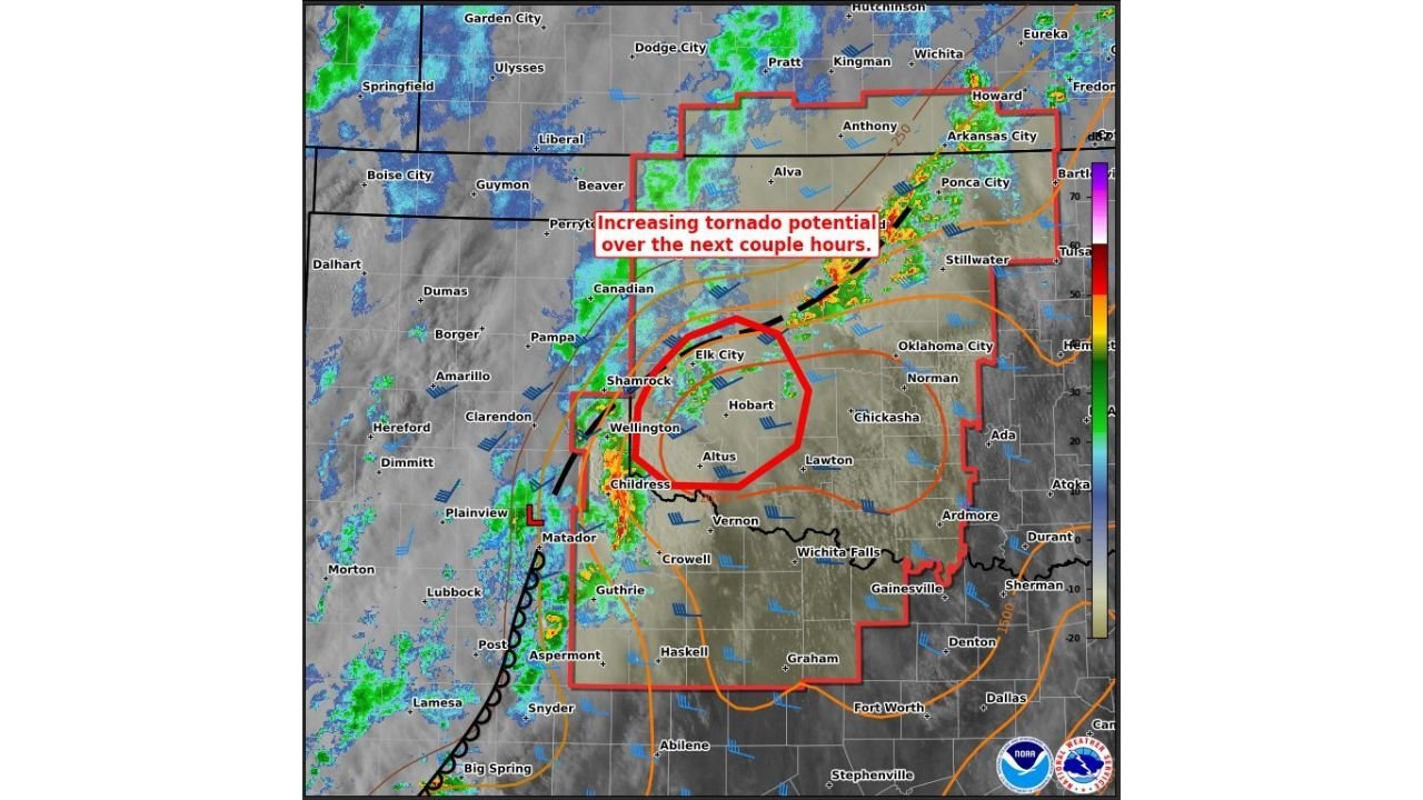
OKLAHOMA, TEXAS — The Storm Prediction Center (SPC) has issued a Mesoscale Discussion highlighting a rapidly increasing tornado threat across southwestern Oklahoma and northern Texas, particularly near Childress, Texas, and Elk City, Oklahoma. This update comes within Tornado Watch 86, as storms begin organizing and strengthening in an increasingly volatile environment.
Storms Intensifying Near Childress as Tornado Risk Begins to Climb
Current observations show thunderstorms developing and strengthening near the triple point around Childress, Texas, where key weather boundaries are intersecting. This area is often a hotspot for severe weather, and early signs indicate that storms are already producing strong wind gusts.
As these storms continue moving northeast into southwestern Oklahoma, they are expected to encounter warmer temperatures, higher humidity, and greater instability. This combination will allow storms to intensify further, increasing the likelihood of rotating thunderstorms capable of producing tornadoes.
Areas including Wellington, Shamrock, and Altus are positioned directly in the path of this evolving system, making them especially vulnerable as conditions continue to worsen over the next several hours.
Atmospheric Setup Supports Strong and Persistent Rotating Storms
One of the key concerns in this setup is the strengthening of the low-level jet during the evening hours, which will enhance wind speeds and directional changes with height. This process, known as wind shear, is critical for storm rotation.
As winds increase and turn with altitude, storms are more likely to become organized supercells, which are capable of sustaining rotation for extended periods. This significantly raises the risk for tornado development, including the potential for strong tornadoes.
In addition to tornadoes, the environment supports very large hail, potentially up to 2.00 to 3.50 inches in diameter, along with damaging wind gusts reaching 65 to 80 mph. These hazards could develop quickly as storms intensify and track northeast across the region.
Tornado Watch 86 Signals Elevated and Ongoing Severe Threat
The inclusion of this area within Tornado Watch 86 indicates that conditions are already favorable for severe weather, and the situation is expected to become more dangerous in the short term. The Mesoscale Discussion further emphasizes that the tornado threat will ramp up over the next couple of hours, making this a time-sensitive situation.
Communities across Elk City, Hobart, Altus, and surrounding areas in southwestern Oklahoma, along with nearby regions in northern Texas, should remain on high alert. The presence of a well-defined storm line and increasing rotation signals a transition toward a more organized severe weather event.
The environment is evolving quickly, and storms that are currently developing could become significantly stronger within a short window, increasing the risk for impactful weather conditions.
What Residents Should Expect Through the Evening Hours
As the evening progresses, storms are expected to expand in coverage and intensity, moving from northern Texas into southwestern and central Oklahoma. This could lead to multiple rounds of severe weather, including tornadoes, hail, and damaging winds.
Residents are strongly encouraged to have multiple ways to receive warnings, including weather alerts and local updates. Identifying safe shelter locations and staying aware of changing conditions will be essential as the threat continues to increase.
Given the rapid intensification expected, even areas that are currently experiencing only light rain or isolated storms could see significant severe weather impacts within a short period of time.
As this severe weather event unfolds across Oklahoma and Texas, staying informed and prepared will be critical. For continued updates on tornado risks, storm developments, and real-time weather coverage, visit ChicagoMusicGuide.com.