
Oklahoma, Arkansas, Missouri, Kentucky, Tennessee, West Virginia, Virginia, North Carolina and Maryland Brace for Heavy Snow, Damaging Ice and Prolonged Winter Storm Impacts
UNITED STATES — A long-duration winter storm is taking shape across a wide swath of the country, with multiple days of snow, sleet, and freezing rain expected from the Southern Plains through the Ohio Valley and into the Mid-Atlantic. Forecast guidance shows a clear north–south split between heavy snow on the colder side of the system and damaging ice just to the south, creating a prolonged period of hazardous travel and infrastructure stress from Friday through early next week.
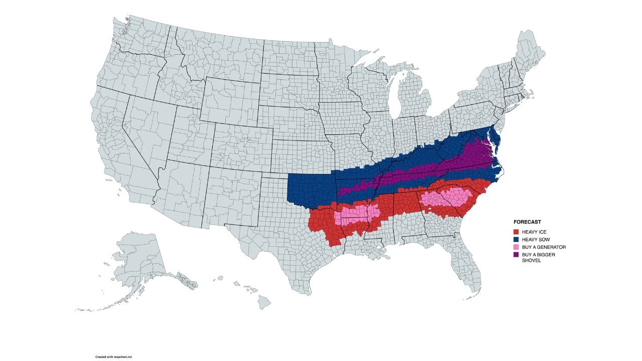
What the Map Is Showing Right Now
The latest data highlights a broad impact zone stretching from Oklahoma eastward to Maryland, with color-coded risks that help explain the threats:
- Blue zones: Heavy snow potential, with plow-required accumulations likely
- Purple zones: Snowfall intense enough to require frequent clearing
- Red zones: Significant ice accretion risk from freezing rain
- Pink zones: Higher-end icing where power outages become a real concern
This setup favors long duration over short bursts, meaning impacts can compound over time even where rates are not extreme at any single hour.
Heavy Snow Corridor: Oklahoma to Maryland
Colder air north of the storm track supports widespread snow from Oklahoma and Missouri through Kentucky, West Virginia, Virginia, and into Maryland. Within this zone:
- Snow may fall in waves, allowing totals to steadily climb
- Roads could remain snow-covered for extended periods
- Visibility may drop during heavier bands, especially at night
- Mountain terrain in West Virginia and western Virginia may enhance totals
Even moderate snowfall becomes disruptive when it lasts 36–60 hours, increasing the risk of spin-outs, stranded vehicles, and slow emergency response times.
Dangerous Ice South of the Snow Line
Just south of the heaviest snow, Arkansas, Tennessee, North Carolina, and parts of Kentucky and Virginia face a much more dangerous threat: freezing rain.
Unlike snow, ice adheres to everything—roads, trees, power lines, bridges—and even a small glaze can cause:
- Widespread power outages
- Downed trees and limbs
- Impassable roads, especially on hills and overpasses
- Long restoration timelines if ice persists
Some areas may remain locked in freezing rain or sleet for many hours, significantly increasing the risk of infrastructure damage.
Why This Storm Is Especially Concerning
Several factors elevate the risk with this system:
- Cold air is firmly established, limiting melting between waves
- The storm’s track may shift slightly, altering snow-to-ice boundaries
- Mixed precipitation zones are notoriously hard to forecast precisely
- Impacts extend day and night, increasing cumulative stress on travel and utilities
Even small changes in temperature profiles aloft could shift locations from snow to sleet or freezing rain with little warning.
Travel and Safety Impacts
Residents across the impact zone should prepare for major travel disruptions, particularly from Friday night through Sunday:
- Avoid non-essential travel during periods of freezing rain
- Expect delays on interstates and secondary roads
- Airports in the snow and ice corridor may experience cancellations
- Emergency services could face slower response times in worst conditions
What Residents Should Do Now
Preparation is key before conditions deteriorate:
- Adjust travel plans early
- Protect pipes, pets, and vulnerable plants
- Charge devices and prepare backup power where ice is possible
- Monitor local forecasts closely as finer details become clearer
Stay Informed
This storm will continue to evolve, and small forecast shifts matter. Updates over the next 24–48 hours will better define where snow ends and ice begins — the most critical detail for safety planning.
What are you seeing where you live — snow already falling, or preparations underway? Share your local conditions and stay weather-aware with the community at ChicagoMusicGuide.com.