
Oklahoma, Kansas and Nebraska in 30% Severe Storm Zone Friday as Tornado, Large Hail and Damaging Wind Threat Expands into Iowa, Missouri and Western Illinois
UNITED STATES — A significant severe weather setup is taking shape for Friday, March 6, 2026, with a focused 30% severe weather risk centered from central and eastern Oklahoma northward through eastern Kansas into far southeast Nebraska and western Iowa.
Surrounding that higher-risk corridor, a broader 15% risk area stretches from north Texas through much of Oklahoma and Kansas into Missouri, Iowa, southern Minnesota, Wisconsin and western Illinois — putting parts of the Midwest, including areas not far from Chicago, on alert.
Where the Greatest Risk Is Centered
The most concerning zone — the 30% corridor — includes:
- Tulsa and eastern Oklahoma
- Wichita and eastern Kansas
- Areas near Topeka and Kansas City
- Far southeast Nebraska
- Western Iowa
Within this corridor, all severe hazards are possible, including:
- Tornadoes
- Large hail
- Damaging straight-line winds
Forecasters emphasize that the greatest concentration of intense storms is expected within this central swath.
Broader 15% Risk Reaches into Missouri, Iowa and Western Illinois
Beyond the core zone, severe potential expands outward into:
- Dallas–Fort Worth and north Texas
- Much of Oklahoma and Kansas
- Missouri, including Kansas City and possibly St. Joseph
- Central and eastern Iowa
- Southern Minnesota
- Much of Wisconsin
- Western Illinois
This places communities across the central Plains and parts of the Upper Midwest in a zone where scattered severe storms could still develop.
For Illinois readers, the western portion of the state sits on the edge of this broader risk, meaning storms organizing farther west could track northeast later Friday into early Saturday.
Atmospheric Setup Favors Supercells First
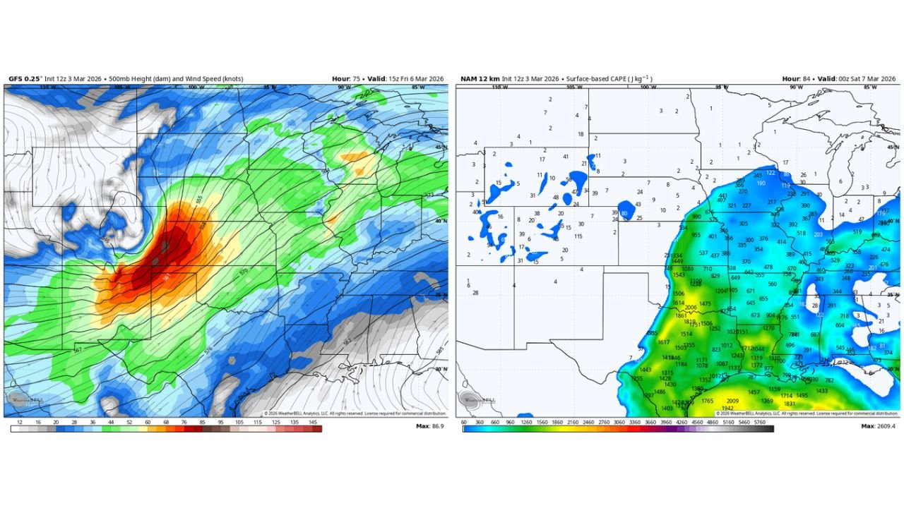
A strong upper-level system ejecting into the Plains will overspread a warm, moist and increasingly unstable air mass Friday afternoon.
As temperatures climb and CAPE (Convective Available Potential Energy) increases across Oklahoma and Kansas, storms are expected to:
- Develop across the southern and central Plains
- Organize into discrete supercells
- Track northeast into Iowa and potentially toward the Upper Midwest
Discrete supercells early in the event are particularly concerning because they are capable of producing:
- Tornadoes
- Very large hail
- Intense localized wind damage
Wind Shear and Jet Support Increase the Threat
Model guidance shows strong mid-level winds overspreading the region Friday afternoon and evening. This wind energy, combined with rich low-level moisture surging north from the Gulf, creates an environment supportive of rotating thunderstorms.
The setup resembles a classic early-season Plains outbreak pattern:
- Deep trough digging into the western U.S.
- Strong southwest flow aloft
- Surface low organizing across the central Plains
- Warm sector expanding northward into Iowa
With these ingredients aligned, forecasters note the potential for an impactful severe weather outbreak if storms remain semi-discrete before merging into lines.
Timing: Afternoon Through Overnight
Storms are expected to initiate Friday afternoon across:
- Oklahoma
- Kansas
- Portions of north Texas
As they intensify, storms may organize and track northeast into:
- Iowa
- Missouri
- Possibly southern Minnesota and Wisconsin
Severe potential could continue into Friday night as storms move toward the Midwest.
Why This Matters for the Midwest
While the highest probabilities sit west of Illinois, the broader 15% risk area reaches into western Illinois, meaning any eastward shift in storm development could bring strong storms closer to the Chicago region.
Even if the most intense activity remains west, the system responsible for Friday’s severe weather will likely influence weekend weather across the Great Lakes with rain, thunder and gusty winds.
Bottom Line
Friday, March 6 could mark the season’s first widespread severe weather event from Oklahoma and Kansas into Nebraska and Iowa, with tornadoes, large hail and damaging winds all possible.
Communities from Tulsa and Wichita to Omaha and Des Moines should stay alert, especially during the afternoon and evening hours.
ChicagoMusicGuide.com will continue monitoring updates as forecast details sharpen heading into Friday.