
Oklahoma, Kansas and North Texas Under Tornado Watch 86 as Storms Intensify Near Oklahoma City, Wichita Falls and Tulsa With Strong Tornado and 80 MPH Wind Threat
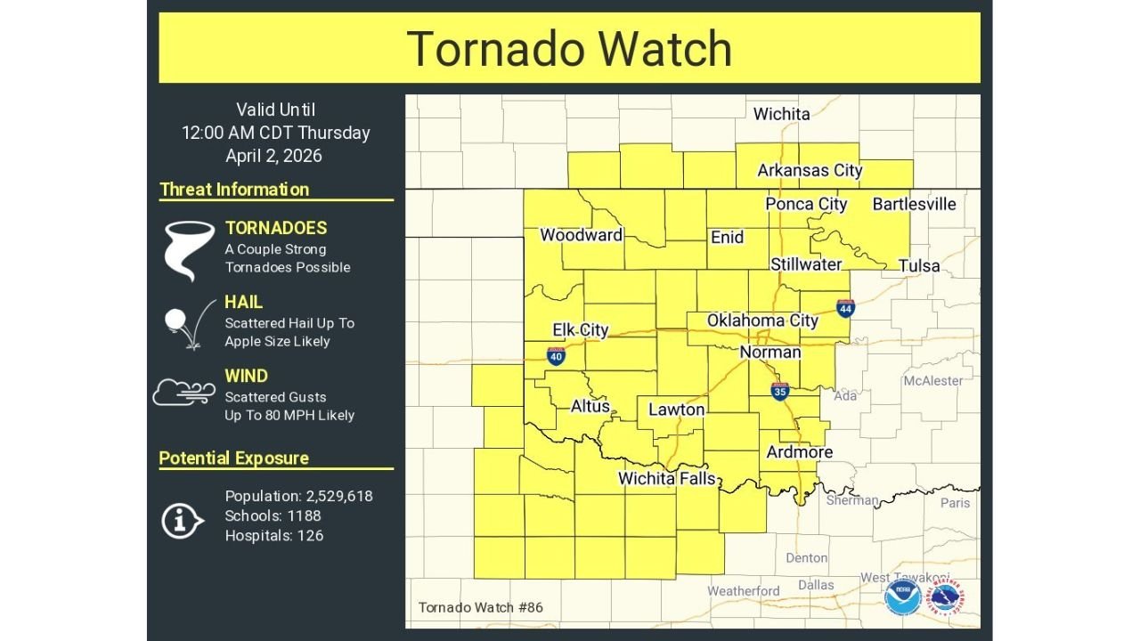
OKLAHOMA, KANSAS, TEXAS — The Storm Prediction Center (SPC) has issued Tornado Watch 86, covering large portions of western and central Oklahoma, southern Kansas, and western North Texas, as a dangerous severe weather setup begins to unfold. The watch remains in effect from 4:40 PM until Midnight CDT, with multiple hazards expected to develop as storms rapidly intensify across the region.
Tornado Watch 86 Covers Major Cities Including Oklahoma City, Tulsa and Wichita Falls
The watch area includes several major population centers such as Oklahoma City, Tulsa, Norman, Wichita Falls, Lawton, Enid, and Stillwater, placing millions of residents within the zone of concern. Portions of southern Kansas, including areas near Wichita and Arkansas City, are also included in the watch.
This widespread coverage reflects the high confidence in severe storm development, with conditions already becoming favorable for rotating thunderstorms capable of producing tornadoes. The inclusion of both urban and rural areas highlights the potential for significant impacts across a large geographic region.
Strong Tornadoes, Large Hail and Damaging Winds All Possible
According to the SPC, the primary threats within Tornado Watch 86 include a few tornadoes, including the possibility of a couple of strong tornadoes, along with scattered damaging wind gusts up to 80 mph and large hail, potentially reaching up to 3 inches in diameter.
Early in the event, storms are expected to remain isolated and discrete, which is a key factor in increasing tornado potential. Discrete supercells are more likely to maintain rotation and produce larger hail and tornadoes, including stronger events.
As the evening progresses, storms are expected to expand and merge into a more linear system, increasing the overall threat for widespread damaging winds while still maintaining a risk for tornadoes and hail into the nighttime hours.
Storms Developing Near Triple Point and Expanding Eastward
Storm activity is already beginning to organize across western Oklahoma and western North Texas, with initial development expected near key atmospheric boundaries. Over the next several hours, this activity will increase in coverage and intensity, spreading eastward across central Oklahoma and into surrounding states.
Areas including Elk City, Altus, and Lawton may see some of the earliest impacts, with storms strengthening as they move toward Oklahoma City and Tulsa later in the evening. The expansion of the storm system suggests that multiple rounds of severe weather could impact the region before conditions begin to settle overnight.
This progression also means that communities farther east may experience intensifying storms later in the evening, emphasizing the need for continued monitoring even if conditions are initially quiet.
Transition From Isolated Storms to Widespread Wind Threat Overnight
One of the key concerns highlighted in this setup is the expected transition from isolated supercells to a more organized line of storms. While the early phase favors tornadoes and very large hail, the later phase increases the risk for widespread damaging wind events.
This transition can lead to a broader impact area, with strong winds causing power outages, tree damage, and hazardous travel conditions across multiple states. Despite this shift, the tornado risk will not completely disappear, and embedded tornadoes may still occur within the evolving storm line.
The combination of hazards makes this a high-impact severe weather event, requiring attention throughout the evening and into the overnight hours.
What Residents Should Do as Severe Weather Threat Increases
With Tornado Watch 86 in effect, residents across Oklahoma, Kansas, and North Texas should take immediate steps to prepare for severe weather. This includes ensuring access to weather alerts, emergency notifications, and safe shelter locations.
Communities in Oklahoma City, Wichita Falls, Tulsa, and surrounding areas should remain especially alert, as these locations are expected to see some of the most intense storm activity.
Even if storms begin as isolated cells, the environment supports rapid intensification, meaning conditions can deteriorate quickly. Being prepared ahead of time is critical as warnings may be issued with little notice.
As severe storms continue to develop across the Southern Plains, staying informed will be essential for safety. For ongoing updates on tornado watches, storm developments, and regional weather coverage, visit ChicagoMusicGuide.com.