Oregon, California, and Washington Face Potentially Dangerous Christmas Eve Wind Storm as Models Trend Stronger

OREGON — Forecast confidence is increasing that a powerful region-wide wind storm could impact much of the West Coast around December 23 and Christmas Eve, with California, Oregon, and Washington now firmly in focus. Updated weather models show a growing signal for damaging wind gusts, coastal impacts, and hazardous travel conditions as a strong Pacific system moves ashore.
Meteorologists caution that while details are still evolving, the overall trend has shifted toward a stronger and more expansive storm, prompting heightened concern from Southern California northward through the Pacific Northwest.
Forecast Models Trend Stronger for December 23–24 Storm
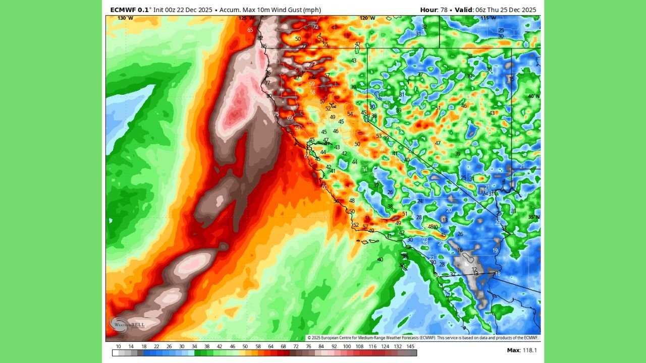
Latest guidance from high-resolution forecast models shows a notable increase in projected wind intensity compared to earlier runs. The system is expected to deepen rapidly offshore before pushing inland, tightening pressure gradients along the coast and producing widespread high wind potential.
This trend suggests a large-scale storm event rather than a localized wind episode, with impacts stretching from coastal California into Oregon, Washington, and possibly southwest British Columbia. Forecasters emphasize that additional refinements are expected, but the strengthening signal is consistent across multiple model updates.
California Braces for Powerful Coastal and Inland Wind Gusts
In California, the storm could bring strong to potentially damaging wind gusts along the coast and through wind-prone interior valleys. Model projections indicate gusts exceeding 50–60 mph in exposed areas, with higher values possible in coastal headlands, mountain passes, and ridgelines.
Southern and Central California appear especially vulnerable due to the orientation of the storm’s wind field. Combined with already saturated soils from recent rain events, strong winds could down trees, damage power lines, and create scattered power outages, particularly during the busy holiday travel period.
Oregon and Washington Face Elevated Risk of Widespread Wind Damage
Farther north, Oregon and Washington may see even stronger wind impacts, especially near the coastline and through the Cascade foothills. Forecast maps show intense wind cores pushing onshore, with gusts potentially reaching 60–80 mph in exposed coastal zones.
Urban areas, including the I-5 corridor, could experience travel disruptions, falling debris, and utility interruptions if the storm verifies near its current intensity. Emergency planners note that Christmas Eve timing could complicate response efforts if outages or road closures occur.
Storm’s Large Size Raises Region-Wide Concern
One of the most notable aspects of this forecast is the sheer size of the storm system. Rather than impacting a single state, current projections show simultaneous hazards across California, Oregon, and Washington, increasing the likelihood of widespread impacts rather than isolated incidents.
The storm’s offshore wind field also raises concerns for dangerous marine conditions, including high seas and gale- to storm-force winds for shipping lanes and coastal communities.
Uncertainty Remains, But Vigilance Is Urged
Meteorologists stress that key details remain unresolved, including exact landfall location, peak wind timing, and inland penetration. Even so, the consistent strengthening trend has prompted calls for early preparedness across the West Coast.
Residents are encouraged to:
- Secure outdoor decorations and holiday displays
- Prepare for possible power outages
- Avoid unnecessary travel during peak wind periods
- Closely monitor local forecasts and alerts
With Christmas Eve now a focal point for potential impacts, forecasters say the next 24–48 hours of model updates will be critical in determining whether this event becomes a high-impact West Coast wind storm.
As California, Oregon, and Washington monitor this evolving threat, staying informed will be essential during one of the busiest travel weeks of the year. For continued updates on severe weather developments and regional forecasts, visit ChicagoMusicGuide.com.
