
Overnight Squall Line Roars From Kansas Through Iowa Toward Illinois With 60–70 MPH Winds and Possible Spin-Up Tornadoes
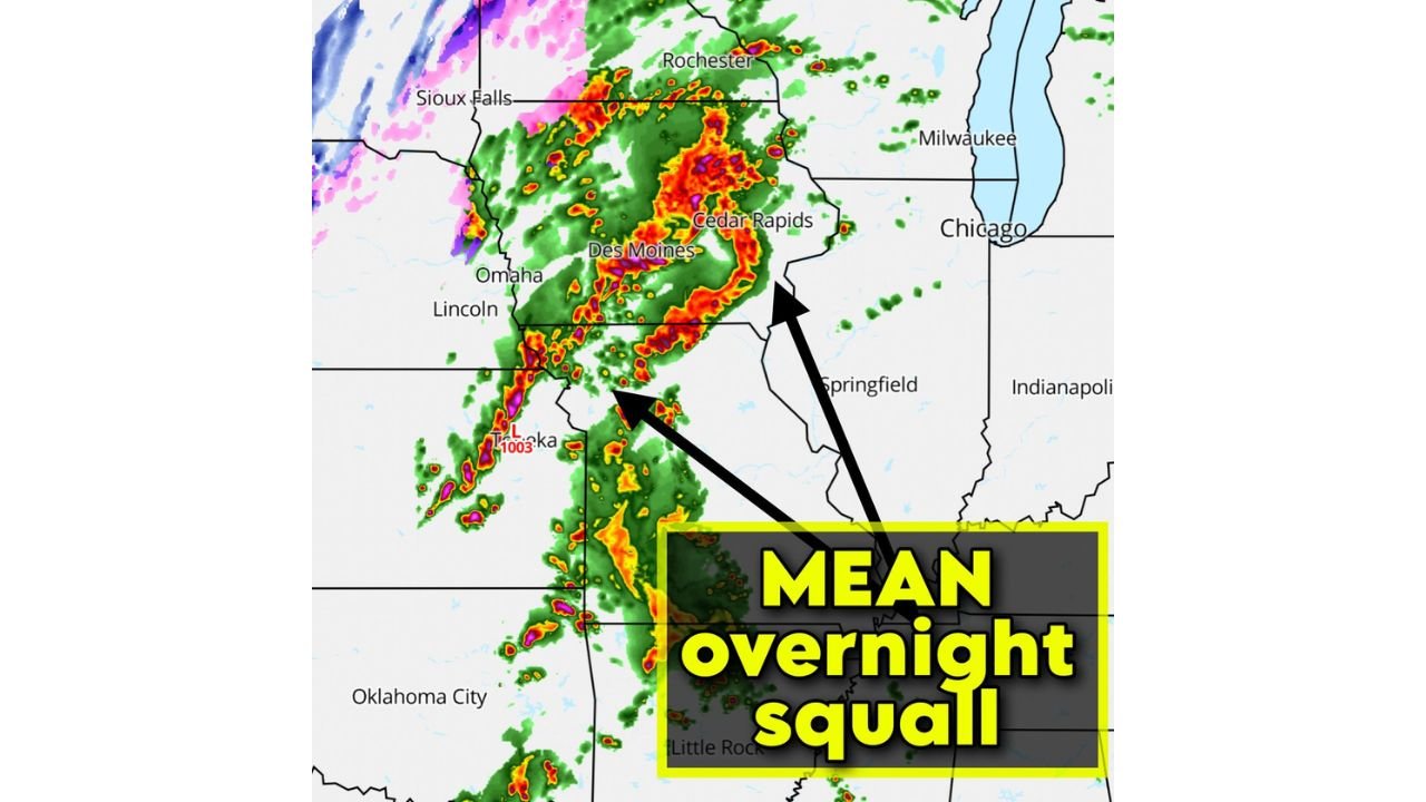
DES MOINES, IOWA — A powerful quasi-linear convective system (QLCS) is sweeping across parts of the Central Plains and Midwest, bringing the threat of damaging winds and isolated tornadoes overnight across Iowa, Kansas, Missouri, and western Illinois. Meteorologists say the fast-moving squall line is strengthening as it pushes northeast through the region, with radar imagery showing intense storms centered near Des Moines and Cedar Rapids in Iowa and extending southwest toward Topeka in Kansas.
Forecasters warn that storms embedded within this line may produce wind gusts between 60 and 70 miles per hour, capable of causing localized damage to trees and power lines. The system is also capable of producing brief spin-up tornadoes, which often develop quickly along the leading edge of a fast-moving squall line.
QLCS Storm Line Intensifies Across Iowa and Northern Missouri
Radar imagery shows a large and organized cluster of storms moving through central and eastern Iowa, with particularly strong thunderstorms near Des Moines and Cedar Rapids. The system forms a curved bowing structure, a signature often associated with strong wind-producing storms.
Farther south, storms continue along a connected line stretching through northeast Kansas and northern Missouri, including areas near Topeka and Kansas City. This long band of thunderstorms is typical of a QLCS system, where storms merge into a single line but still contain localized pockets of intense rotation.
Meteorologists say these types of storm systems can produce damaging straight-line winds across a wide area, sometimes affecting several states in a single overnight event.
Western Illinois and Parts of the Midwest Next in the Storm’s Path
As the storm line pushes eastward, the system is expected to move into western Illinois and additional parts of the Midwest overnight. Communities including Springfield, Peoria, and areas west of Chicago could see storms approach as the line continues moving across the region.
While the storms are not expected to produce widespread long-track tornadoes, forecasters caution that QLCS systems often generate short-lived tornadoes embedded within the line, making them harder to detect and sometimes allowing them to form with little warning.
Cities near the Mississippi River corridor, including Davenport and the Quad Cities region, may also see strong thunderstorms as the system advances eastward.
Damaging Wind Gusts the Primary Overnight Hazard
Meteorologists emphasize that the primary threat from this overnight storm system will be damaging winds, with gusts potentially reaching 60 to 70 miles per hour in the strongest segments of the line. These winds can cause scattered power outages, fallen tree limbs, and structural damage in areas directly impacted by the storms.
Embedded storm circulations may also produce isolated spin-up tornadoes, particularly where the squall line develops small kinks or bowing segments. These brief tornadoes can develop rapidly and may occur with little advance warning.
Forecasters urge residents across Iowa, Kansas, Missouri, and western Illinois to remain alert overnight and ensure they have multiple ways to receive severe weather alerts, especially as storms move through during nighttime hours.
As the overnight squall line continues pushing east across the Midwest, meteorologists will be closely monitoring radar trends and issuing updates as the system evolves. For continued coverage of severe storms, weather alerts, and major atmospheric developments across the United States, visit ChicagoMusicGuide.com.