
Pennsylvania and Maryland State Line at Highest Risk as Strong Cold Front Brings Severe Thunderstorm Threat to Washington D.C., Baltimore and Northern Virginia Tonight
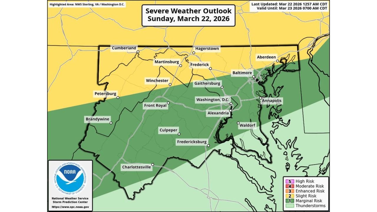
WASHINGTON, D.C. — A strong cold front is set to sweep through the Mid-Atlantic this evening into tonight, bringing showers and thunderstorms to Pennsylvania, Maryland, Washington D.C., and northern Virginia — with the greatest severe threat focused near the Pennsylvania/Maryland state line.
Forecasters warn that some storms could become severe, with large hail and damaging winds as the primary hazards.
Severe Risk Focused North of D.C.
The severe weather outlook for Sunday highlights a broader thunderstorm zone stretching from central Virginia through Washington D.C. and into Maryland and southern Pennsylvania.
Communities under heightened concern include:
- Hagerstown, MD
- Frederick, MD
- Martinsburg, WV
- Cumberland, MD
- Winchester, VA
- Baltimore, MD
- Aberdeen, MD
The most favorable zone for stronger storms appears especially near and just south of the Pennsylvania/Maryland state line, where atmospheric conditions will be more supportive of organized severe development.
Washington D.C. and Northern Virginia in the Storm Zone
The broader thunderstorm area also includes:
- Washington, D.C.
- Alexandria, VA
- Gaithersburg, MD
- Annapolis, MD
- Front Royal, VA
- Fredericksburg, VA
- Culpeper, VA
- Charlottesville, VA
While not every storm will be severe, any stronger cell that forms along the advancing cold front could produce damaging wind gusts capable of downing trees or causing scattered power outages.
Hail and Wind the Main Threats
Forecast guidance emphasizes two primary risks:
- Large hail, especially in stronger updrafts near the state line region
- Damaging straight-line winds, which could exceed severe criteria in isolated storms
The severe hail outlook shows the highest probabilities centered across western Maryland into northern Virginia, including areas around Hagerstown, Frederick, and Winchester.
Similarly, the damaging wind outlook covers much of the same corridor, stretching southeast toward the Baltimore-Washington metro region.
Timing: Evening Into Overnight
The cold front is expected to move through the region during the evening and into the overnight hours. Storms are forecast to develop along and ahead of the boundary, intensifying as they tap into remaining instability.
Residents should monitor conditions closely during the evening commute and before heading to bed, as storms could persist after sunset.
What to Watch For
As the line of storms approaches, key warning signs include:
- Rapidly darkening skies
- Sudden gusty winds
- Frequent lightning
- Hail
If a Severe Thunderstorm Warning is issued, residents should move indoors immediately and stay away from windows.
With a strong frontal boundary driving the setup, tonight’s storms may mark a sharp temperature shift behind the front as cooler air settles in early this week.
For continued updates on significant weather developments across the country, stay with ChicagoMusicGuide.com.