
Pennsylvania, Ohio and West Virginia Weekend Storm Looks Weak as Snow Chances Remain Low and Impacts Limited
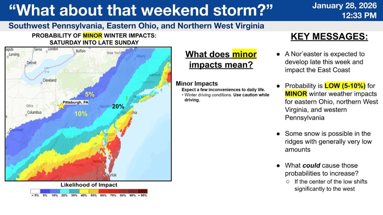
PITTSBURGH, PENNSYLVANIA — Updated forecast guidance shows that the potential weekend storm being monitored across southwestern Pennsylvania, eastern Ohio, and northern West Virginia continues to pose low risk for snow and winter impacts. According to the National Weather Service Pittsburgh, probabilities for minor winter impacts remain limited, with any snowfall expected to be light, localized, and mainly confined to higher elevations.
Forecasters note that while a system may develop late this week and pass through the region Saturday into late Sunday, confidence remains low that it will produce meaningful snow or widespread disruptions.
Snow Probabilities Remain Low Across Most of the Region
The latest probability maps for at least one inch of snow Sunday show much of western Pennsylvania and eastern Ohio at or near 0%, including the Pittsburgh metro area. Pittsburgh itself currently carries only a 10% chance or less of seeing one inch of snow, reinforcing expectations that most locations will see little to no accumulation.
Farther southeast, probabilities gradually increase, but still remain modest. Portions of southern West Virginia and south-central Pennsylvania show higher chances, generally ranging from 20% to 40%, with the highest values staying well south and east of Pittsburgh.
Any Snow Likely Limited to Ridges and Higher Elevations
Forecasters emphasize that any accumulation that does occur is most likely in the ridges, particularly across eastern West Virginia and adjacent high terrain. Even in these areas, snowfall amounts are expected to remain generally low, with impacts described as minor.
Minor impacts typically include brief slick spots on roads, reduced visibility during any short-lived snow showers, and limited travel slowdowns — not widespread closures or significant disruptions.
Models Shift Slightly East, Reducing Local Impact Risk
Recent model trends show a slight eastward shift in the storm track, which further lowers snow potential for much of western Pennsylvania, eastern Ohio, and northern West Virginia. This shift keeps the better moisture and lift displaced away from the region, reducing the likelihood of meaningful winter weather locally.
Forecasters note that while models can continue to adjust, current guidance consistently supports a low-impact outcome for most communities in the forecast area.
What This Means for Travel and Planning
With probabilities remaining low, most residents across Pennsylvania, Ohio, and West Virginia should expect minimal disruption from this system. However, travelers heading east or southeast along the East Coast may encounter more wintry conditions and are encouraged to monitor forecasts closely if travel plans extend beyond the local region.
Officials stress that while the system bears watching, it does not currently appear to be a significant winter storm for the Pittsburgh forecast area.
As forecast confidence continues to improve heading into the weekend, residents are encouraged to stay updated in case subtle shifts increase local impacts. For continued weather updates, forecast breakdowns, and regional impact analysis, visit ChicagoMusicGuide.com.