
Peoria, Springfield and Macomb in Illinois Face Immediate Tornado Threat as Supercell Strengthens Near Warm Front While Iowa Storm Pushes North
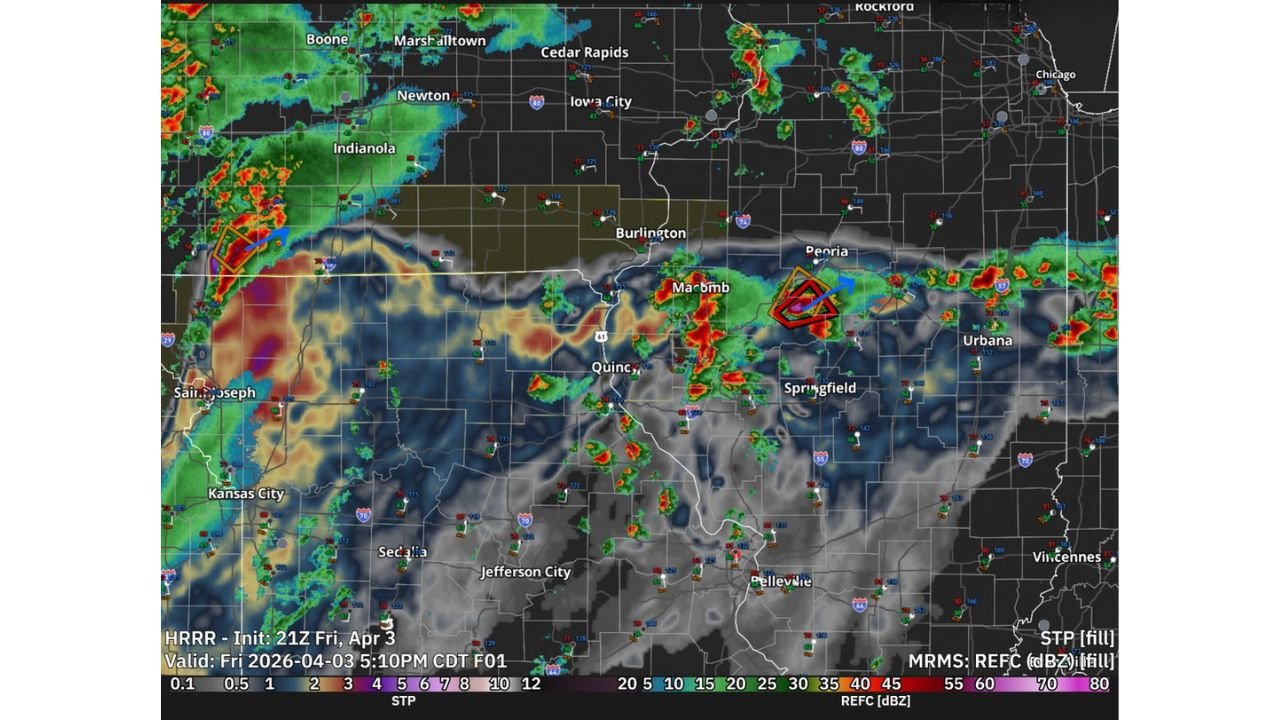
PEORIA, ILLINOIS — A dangerous weather setup is unfolding across Central Illinois this evening as a strengthening supercell near Peoria, Springfield, and Macomb shows increasing potential to produce a tornado in the near term. Meanwhile, a separate storm in Iowa continues to intensify and track north, highlighting a split severe weather scenario across the region.
Supercell Near Peoria and Springfield Showing Tornado Potential
Radar and atmospheric analysis indicate that the supercell positioned just south of the warm front in Central Illinois is currently in the most favorable environment for tornado development. Areas including Peoria, Springfield, and Macomb are directly in the path of this storm, which is exhibiting strong rotation and organization.
The positioning of this storm relative to the warm front is critical. Storms located along or just south of this boundary often benefit from enhanced low-level wind shear, a key ingredient for tornado formation. This environment is allowing the storm to maintain structure and increase its intensity as it moves eastward.
Residents in these areas should remain alert as conditions could change rapidly, especially if the storm continues to strengthen or becomes more organized.
Iowa Supercell Growing but Moving Away from Primary Risk Zone
At the same time, a supercell in Iowa, affecting areas near cities like Indianola and Newton, has shown signs of growing upscale and becoming more expansive. However, this storm is tracking northward along the very nose of the warm front, which may limit its ability to produce tornadoes compared to the Illinois storm.
While still capable of producing heavy rain, lightning, and strong winds, the Iowa storm appears to be transitioning into a more clustered or linear system, reducing the immediate tornado risk relative to the more discrete supercell in Illinois.
This contrast between the two storms highlights how small differences in storm position and environment can significantly impact severe weather potential.
Warm Front Position Creating a Focused Severe Weather Corridor
The presence of a well-defined warm front stretching across Illinois into surrounding states is acting as a focal point for storm development. Along this boundary, temperature contrasts and wind shear are maximized, creating a narrow corridor where storms can rapidly intensify.
The Central Illinois corridor from Macomb to Peoria and Springfield is currently sitting in this prime zone, making it the area of greatest concern for isolated tornado development in the short term.
Storms forming farther north into Iowa are interacting differently with the boundary, which explains their evolving structure and reduced tornado efficiency.
What Residents Should Expect Through the Evening
As the evening progresses, the Central Illinois supercell will continue moving east or east-northeast, potentially impacting additional communities beyond Peoria and Springfield.
Primary threats include:
- Isolated tornadoes, especially with the strongest rotating cells
- Damaging wind gusts
- Frequent lightning and heavy rainfall
Given the evolving nature of this system, warnings could be issued quickly, and residents should be prepared to seek shelter immediately if conditions worsen.
Meanwhile, areas in Iowa and western Illinois may still experience strong storms, but the highest tornado risk remains focused in Central Illinois at this time.
For continued severe weather updates, storm tracking, and real-time alerts, visit ChicagoMusicGuide.com.