
Philadelphia, Allentown, Trenton and Wilmington Brace for Late-Day Severe Storms as Damaging Winds, Large Hail and Isolated Tornado Risk Target Pennsylvania, New Jersey and Delaware
PHILADELPHIA, PENNSYLVANIA — Severe thunderstorms are possible late Sunday afternoon and evening across portions of eastern Pennsylvania, New Jersey, Delaware, and northeastern Maryland, with the greatest concern centered on the Philadelphia metro region and surrounding communities.
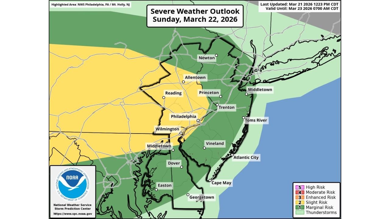
The National Weather Service highlights a corridor including Philadelphia, Allentown, Reading, Wilmington, Trenton, Princeton, Newton, and portions of central and southern New Jersey within a Level 2 (Slight) risk for severe weather.
Best Timing: 4 PM to 10 PM
Forecasters indicate the most favorable window for severe storm development will be between 4 PM and 10 PM Sunday, when daytime heating and atmospheric dynamics align.
Storms are expected to develop and intensify during the late afternoon, potentially impacting the I-95 corridor during peak travel and early evening hours.
Main Threats: Damaging Winds and Large Hail
The primary hazards with this system are:
- Damaging straight-line winds
- Large hail
Stronger thunderstorms may produce wind gusts capable of downing tree limbs and causing scattered power outages. Large hail is also possible in the more intense cells, especially during early development before storms organize into clusters or lines.
Communities from Reading and Allentown south through Philadelphia and Wilmington, and eastward into Trenton and central New Jersey, are within the zone of greatest concern.
Isolated Tornado and Flash Flood Risk
While not the primary threat, forecasters note that an isolated tornado cannot be ruled out, particularly if any storms become briefly organized or rotate.
In addition, isolated instances of flash flooding are possible where heavier downpours repeatedly track over the same areas. Urban centers such as Philadelphia, Trenton, and Wilmington could see localized street flooding if rainfall rates become intense.
Slight Risk Across the I-95 Corridor
The Slight Risk area covers much of southeastern Pennsylvania and parts of western and central New Jersey, while surrounding regions remain under a Marginal Risk.
This setup suggests scattered severe storms are possible, though not every community will experience severe impacts. However, any storm that strengthens could quickly become hazardous.
Stay Weather Aware
Residents across Pennsylvania, New Jersey, Delaware, and northeastern Maryland should remain alert Sunday afternoon and evening. With temperatures warm and instability building during the day, conditions will be supportive of stronger thunderstorms once storms initiate.
Having multiple ways to receive weather warnings and identifying a safe shelter location in advance is strongly encouraged.
As the region prepares for another round of late-day severe weather, updates will continue as confidence in timing and storm intensity evolves.
For ongoing coverage of severe weather threats across the Midwest and Mid-Atlantic, stay with ChicagoMusicGuide.com.