
Potential Mid-March Pattern Shift Could Bring Heavy Rain and Severe Storm Risk to Plains, Midwest and Deep South
UNITED STATES — Long-range forecast guidance is signaling a possible pattern change during the second week of March, one that could increase precipitation east of the Rockies and raise the risk of storm activity across the Plains, Midwest, and Deep South.
While still several days away, multiple model graphics show a developing setup that would shift the jet stream configuration, allowing more active weather to spread across central and eastern portions of the country.
Western Trough, Eastern Ridge: The Setup Taking Shape
The 500 mb height anomaly forecast valid around March 8 indicates troughing returning to the Western United States, while a pronounced ridge builds across the Eastern U.S., including the Ohio Valley, Mid-Atlantic, and portions of the Southeast.
This configuration — trough west, ridge east — often promotes:
- Increased storm development over the Plains
- Enhanced Gulf moisture transport northward
- More widespread rainfall east of the Rockies
The anomaly map shows below-average heights across the West, contrasted by above-average heights centered over the eastern half of the country.
Jet Stream Alignment Supports Active Storm Track
The wind analysis at 500 mb reveals a strengthened jet stream stretching from the Southwest into the central Plains and then curving northeastward through the Midwest.
This jet configuration supports:
- Organized storm systems emerging from the Rockies
- Surface low development across the central Plains
- Eastward-moving frontal systems across the Mississippi Valley
Areas including Texas, Oklahoma, Kansas, Missouri, Illinois, and Arkansas appear positioned near the favored storm corridor.
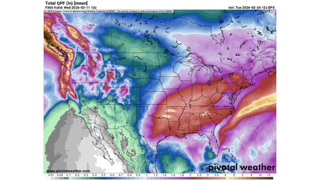
Rainfall Projections Increase Across the Central U.S.
The total QPF projection through March 11 shows enhanced precipitation across:
- Texas and Oklahoma
- The lower Mississippi Valley
- Parts of the Midwest
- The Tennessee Valley and Deep South
Heavier precipitation shading extends from the Southern Plains northeastward into portions of the Midwest and Great Lakes.
This suggests a meaningful uptick in rainfall potential compared to quieter patterns earlier in the month.
Severe Weather Signal Emerging in Week 3 Outlook
The CFSv2 accumulated supercell composite parameter for the week of March 10–16 highlights a concentrated severe weather signal centered over:
- Central and eastern Texas
- Oklahoma
- Western Louisiana
- Southern Arkansas
Lesser but still notable values extend northward into parts of Kansas and eastward into the lower Mississippi Valley.
While long-range severe forecasts carry uncertainty, the clustering of higher composite values suggests an environment that could support organized thunderstorm development if the pattern materializes as projected.
Why This Potential Shift Matters
The combination of:
- Western troughing
- Eastern ridging
- Strengthened jet stream flow
- Increasing Gulf moisture
Creates a classic early-spring setup for more frequent storm systems across the central and eastern United States.
For the Midwest, this could mean more consistent rainfall opportunities. For the Plains and Deep South, it may signal the early stages of a more active severe weather season.
Forecasters caution that this remains a developing signal. Confidence will increase or decrease as additional model runs either reinforce or weaken the projected pattern shift.
Still, the consistency across multiple forecast tools suggests this is a setup worth monitoring closely as the calendar moves toward mid-March.
As we approach the second week of March, ChicagoMusicGuide.com will continue tracking updates on potential rainfall increases, storm development trends, and any emerging severe weather risks affecting the Plains, Midwest, and Southern states.