
Powerful 1053 mb High-Pressure System Over Idaho Set to Drive Brutal Arctic Cold Across the U.S. Next Week
IDAHO — A Rare 1053 mb High-Pressure System Sets the Stage for a Major Arctic Outbreak, A massive 1053 mb surface high-pressure system forming over Idaho late next week is generating serious concern among meteorologists, as new model runs suggest the setup could unleash one of the most intense surges of arctic air the U.S. has seen in years.
The incoming cold pool — originating from deep Canadian polar air — appears ready to dive straight into the central and eastern United States, supported by an unusually powerful high-pressure block. Forecasters warn that the pattern is “wild” and rapidly evolving, with the Pacific jet, Canadian cold dome, and U.S. pressure gradients aligning in a way that strongly favors a major outbreak.
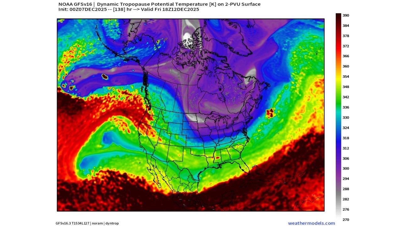
Dynamic Tropopause Maps Show a Direct Transport of Extreme Cold Southward
High-resolution tropopause temperature maps reveal a large, sharply defined lobe of frigid air plunging from northern Canada through the Pacific Northwest and into the Rockies.
This cold pool is directly tied to the 1053 mb high over Idaho, which acts as a driving force pushing dense arctic air downslope and into the central Plains.
Meteorologists note that this type of structure — steep gradients, dense air, and a locked high-pressure dome — is classic for major December cold waves.
Temperature Anomalies Show 20–35°F Below Normal for Several States
GFS anomaly projections for Friday, December 12 show alarming temperature departures:
- Idaho & Montana: 20–30°F below average
- Wyoming & the Dakotas: 25–35°F below average
- Nebraska, Kansas, Colorado: 15–25°F below average
- Midwest (Iowa, Missouri, Illinois): 10–20°F below average
These numbers represent air masses normally seen in mid-January, not early December — a sign of how forceful the incoming pattern is.
Pressure Maps Confirm a Historic Strength High: 1053 mb
Surface pressure charts illustrate the dominant feature:
A 1053 mb high centered over Idaho — a value so strong that it signals exceptionally cold, dense air pooling in the region.
When highs exceed 1050 mb, meteorologists often anticipate hazardous wind chills, rapid temperature drops, and widespread frost/freeze conditions, even deep into the southern states.
This setup resembles major historic cold outbreaks, though it’s too early to determine the full magnitude.
Pacific Pattern Adds Fuel to the System
Meteorologists highlight “a lot going on in the Pacific,” including:
- A highly amplified jet stream
- Energy transfer from the Gulf of Alaska
- Reinforced cold waves feeding into the high-pressure block
This combination provides the necessary momentum for arctic air to surge across thousands of miles.
What This Means for the U.S. Next Week
If the current model trend holds, the U.S. should prepare for:
- Dangerously low wind chills across the northern Rockies and Plains
- Widespread temperature anomalies 15–35°F below normal
- Fast southward transport of arctic air beginning December 11–12
- Potential freezing conditions as far south as Texas and the Gulf Coast
Music fans, outdoor event organizers, and travelers should monitor updates closely as conditions may change rapidly.
Stay Tuned for More Model Updates
The meteorologist who shared the maps emphasized that next week’s pattern is still evolving — but the signal is strong and becoming more organized with every model cycle.
Chicago Music Guide will continue monitoring new data and updates as this powerful Idaho-anchored arctic high continues to develop.
Have you experienced extreme cold events during winter tours or concerts? Share your stories at ChicagoMusicGuide.com!