
Powerful Cold Front May Trigger Brief but Dangerous 60–70 MPH Wind Gusts Across Western and Central New York Friday Afternoon
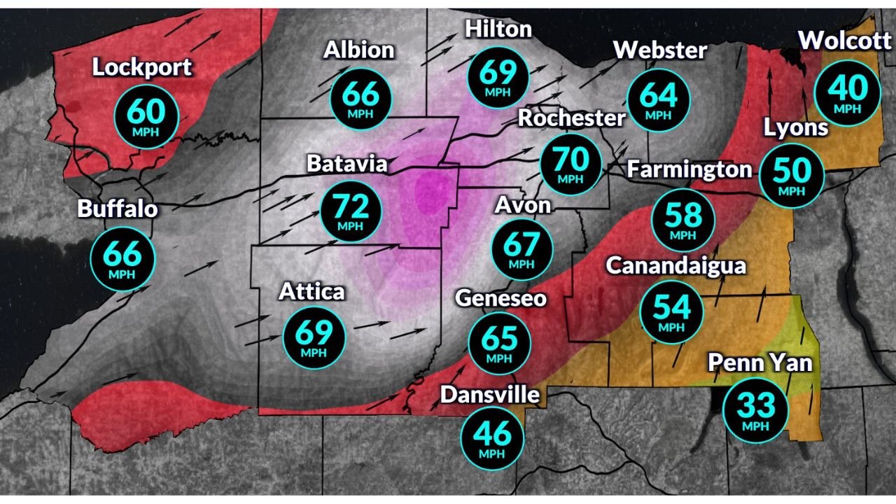
NEW YORK – A fast-moving cold front sweeping across Western and Central New York on Friday could bring a short-lived but potentially damaging burst of wind, with some high-resolution forecast models indicating gusts as high as 60 to 70 miles per hour in parts of the region, including Rochester, Buffalo, Batavia, Albion, Hilton, and surrounding communities.
Meteorologists stress that while the most extreme wind projections may be overdone, the setup still supports at least a brief window of strong to locally damaging winds, particularly during the late afternoon hours as the front passes.
Why Wind Forecasts Are So Uncertain This Time
Forecast models such as the HRRR are showing unusually strong winds just behind the cold front, driven by a powerful low-level jet racing through the atmosphere. In some simulations, this jet briefly mixes down to the surface, producing isolated 65–70 mph gusts, especially near Rochester and northward toward Lake Ontario.
However, forecasters note this is a non-classic high-wind event.
- The strongest winds aloft arrive quickly and briefly
- The well-mixed atmospheric layer is very shallow
- The favorable window for winds to reach the ground may last only one to two hours
Because of this, many experts believe the absolute peak gusts shown on models are too high, but also agree that 40 mph estimates may be too low.
Cities Most Likely to See the Strongest Gusts
Based on current data, the highest wind potential appears focused across:
- Rochester – isolated gusts possibly exceeding 60 mph
- Batavia and Albion – strong post-frontal mixing
- Buffalo and Lockport – enhanced winds near the Lake Erie shoreline
- Hilton, Webster, and Farmington – brief but sharp wind surge
- Geneseo and Attica – 50–65 mph gust potential
Farther south and east, including Dansville, Canandaigua, and Penn Yan, gusts should be lower but still impactful, generally in the 40–55 mph range.
Why This Won’t Be an All-Day Wind Event
Unlike typical high-wind days that last for hours, this system behaves more like a quick atmospheric punch.
- Winds increase rapidly just behind the cold front
- Peak gusts occur in a narrow time window
- Conditions improve relatively quickly once the jet passes
This short duration greatly limits widespread damage, but it does not eliminate risk, especially where trees, power lines, or loose objects are involved.
What Impacts Are Most Likely
Even if only a portion of the strongest winds reach the surface, impacts could include:
- Isolated power outages
- Downed tree limbs and weakened trees
- Hazardous driving conditions, especially for high-profile vehicles
- Blowing debris during the peak gust window
Because the event is brief, widespread structural damage is not expected, but localized issues remain possible.
Bottom Line for Western and Central New York
Forecast confidence is highest that some level of strong wind will occur, but exact peak gusts remain uncertain. While 70 mph gusts are unlikely to be widespread, a brief burst of 50–65 mph winds remains very plausible Friday afternoon.
Residents across Western and Central New York, especially near Rochester and Lake Ontario, should stay alert during the late afternoon hours and be prepared for short-duration but potentially disruptive winds as the cold front moves through.
Stay weather-aware, secure loose items, and be cautious if traveling during the peak wind window.