
Powerful Cyclone Deepening Over Syria and Iraq to Trigger Dangerous Thunderstorms Across Saudi Arabia, Kuwait, Qatar, UAE, Oman and Iran March 26–27
MIDDLE EAST — A powerful low pressure system is forecast to rapidly deepen over Syria and Iraq between Thursday and Friday, March 26–27, setting the stage for widespread violent thunderstorms across large portions of the Arabian Peninsula and the Persian Gulf region.
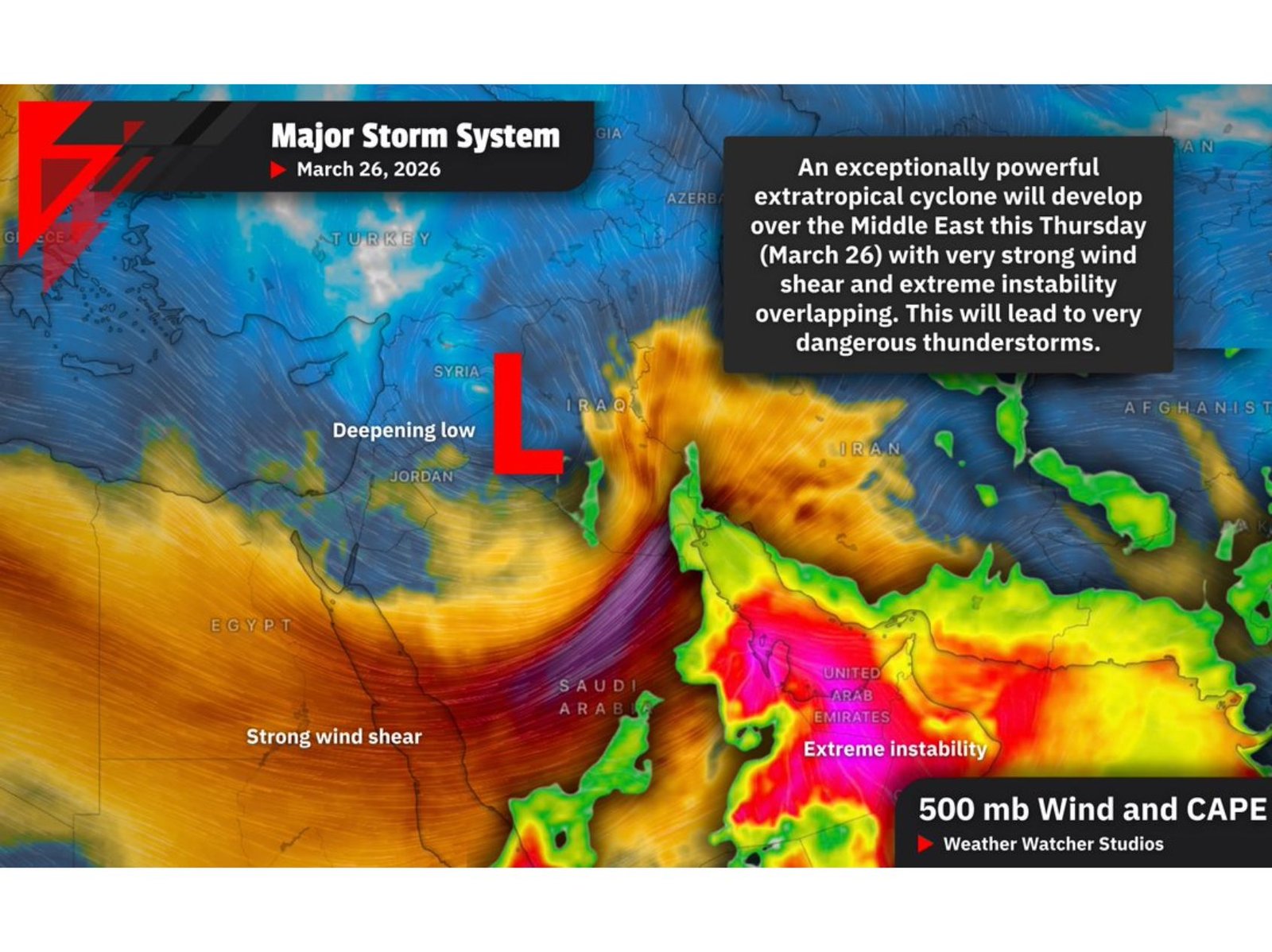
Meteorological analysis shows an exceptionally strong extratropical cyclone developing over the eastern Mediterranean and Mesopotamia, with intense upper-level winds overlapping a zone of extreme atmospheric instability to the south and east.
Deepening Low Over Syria and Iraq
The center of the system is projected to consolidate and intensify over:
- Syria
- Iraq
- Parts of Jordan
As the low strengthens, strong wind shear will expand across the southern and eastern flank of the system — a critical ingredient for organized severe thunderstorms.
Extreme Instability From Saudi Arabia to the Gulf
South of the low, a corridor of rich moisture and extreme instability is forecast to surge northward from:
- Saudi Arabia
- Yemen
This unstable air mass extends toward:
- Kuwait
- Qatar
- United Arab Emirates
- Oman
- Southern portions of Iran
The overlap of powerful wind shear with high instability significantly increases the potential for organized severe convection.
Major Severe Weather Threats
This atmospheric setup supports multiple hazards across the region:
- Extreme rainfall rates, increasing the risk of flash flooding — particularly in areas already affected by recent heavy rains
- Damaging wind gusts, potentially capable of structural damage
- Large to destructive hailstones in stronger supercell storms
- Tornado potential, especially where wind shear is strongest
- Excessive lightning activity
The greatest concentration of instability appears over eastern Saudi Arabia, the UAE and parts of Oman, while strong dynamic forcing spreads northward toward Kuwait and southern Iraq.
Flash Flood Risk Elevated
With deep tropical moisture feeding into the system, thunderstorms could produce intense rainfall in short periods. In desert and urban environments, runoff can occur rapidly, heightening flash flood risk.
If storms train repeatedly over the same locations, localized flooding could become significant.
Thursday–Friday Window Critical
The peak timeframe for the most dangerous conditions appears to be Thursday into Friday, March 26–27, as the low reaches maximum intensity and wind shear aligns with instability across the Gulf states.
Communities across Saudi Arabia, Kuwait, Qatar, the UAE, Oman and parts of Iran should closely monitor updates as this system evolves.
ChicagoMusicGuide.com will continue tracking developments as this powerful Middle East storm system approaches its peak intensity later this week.