
Powerful Tornado Near Nash, Oklahoma Nearly Strikes KVNX Radar as 200 MPH Wind Shear Suggests Possible EF3 Strength
ALFALFA COUNTY, OKLAHOMA — Meteorologists are analyzing a powerful tornado that narrowly missed a major weather radar site Thursday night, after the storm passed dangerously close to the KVNX radar at Kegelman Air Force Auxiliary Field in Alfalfa County.
According to early analysis of radar data, the tornado may have reached intense strength, potentially approaching EF3 intensity, though the official rating will ultimately depend on damage surveys conducted on the ground.
The tornado’s track placed it within just a few miles of the radar installation, providing meteorologists with unusually detailed measurements of the storm’s internal winds.
Tornado Passed Within Miles of Radar Facility
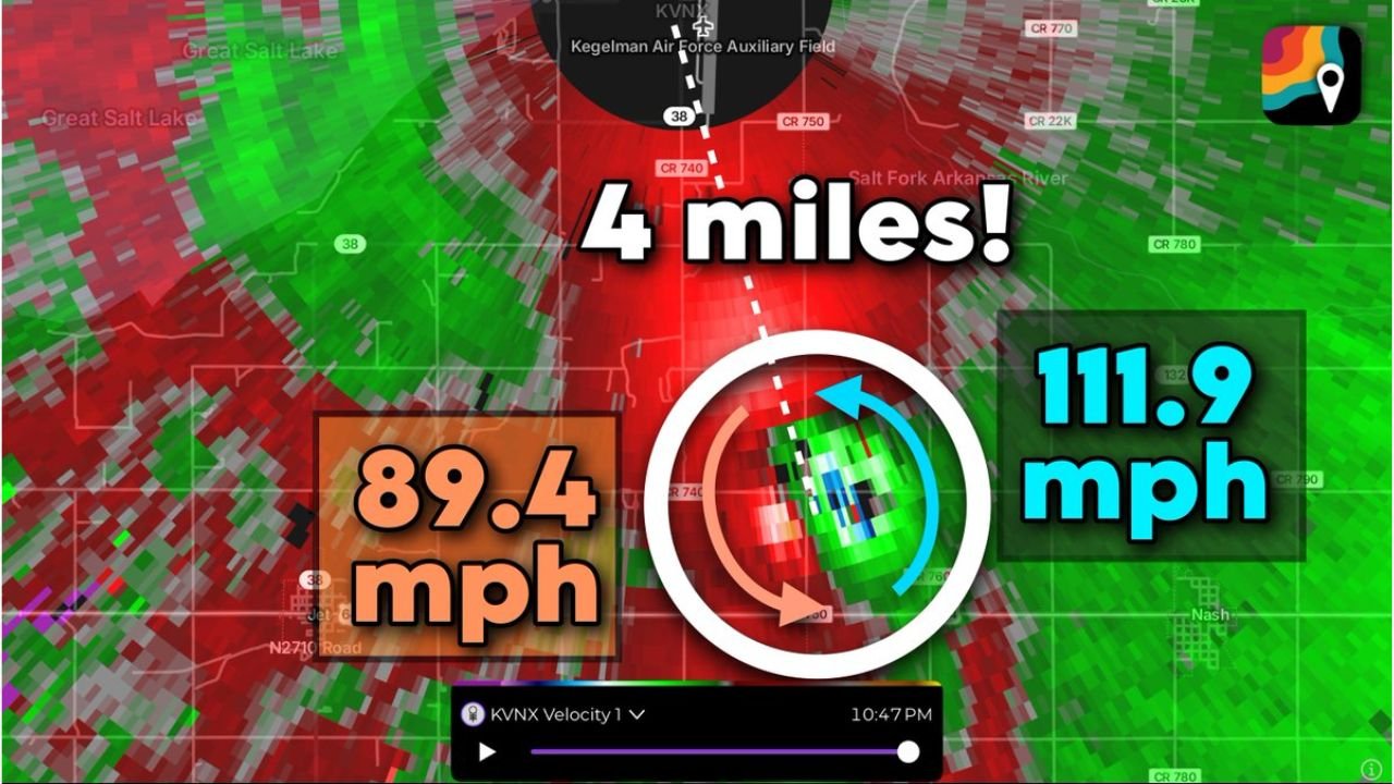
Weather data shows the tornado moved approximately 4.4 miles south of the KVNX radar site, and about 3.1 miles south of the southern end of the runway at Kegelman Air Force Auxiliary Field.
As the storm continued its path, the circulation shifted direction slightly, turning left and passing roughly 2.5 miles east of the airfield.
Despite its proximity to the radar station, the tornado narrowly avoided striking the facility, which allowed scientists to gather highly valuable observations of the storm’s structure and wind speeds.
The tornado also passed close to Nash, Oklahoma, though early reports suggest the town avoided a direct hit.
Radar Detected Extreme Wind Speeds
Because the tornado moved so close to the radar, meteorologists were able to capture clear velocity data from the storm’s circulation.
Radar measurements indicated:
- Inbound winds toward the radar reaching 111.9 mph
- Outbound winds moving away from the radar around 98.4 mph
When combined, those values produce nearly 200 mph of “gate-to-gate shear,” a measurement meteorologists use to estimate the strength of rotation within a tornado-producing storm.
Such strong radar signatures are often associated with significant tornadoes capable of producing major damage.
Possible EF3 Strength Being Investigated
Based on the radar evidence alone, meteorologists say the tornado was likely an intense storm, potentially reaching EF3 strength on the Enhanced Fujita Scale.
However, tornado ratings are determined only after investigators examine actual damage, such as destroyed buildings, snapped trees, or other structural impacts.
If the tornado avoided major structures, it could receive a lower rating despite the powerful winds detected on radar.
Valuable Data for Meteorologists
Storms passing close to radar installations provide rare opportunities for meteorologists to study tornado structure in exceptional detail.
Because the radar beam can sample winds closer to the ground when storms are nearby, the KVNX radar was able to capture low-level wind velocities that are normally difficult to measure.
This type of data helps scientists improve their understanding of tornado formation and behavior, potentially aiding future warning systems.
Tornado Season Increasing Across the Plains
The powerful Oklahoma tornado occurred during a period of increasing severe weather activity across the central United States, as spring storm season begins to ramp up across the Plains.
Meteorologists expect additional severe weather events to develop in the coming weeks as warmer, moisture-rich air from the Gulf of Mexico interacts with colder systems moving across the region.
For continued coverage of major storm events and severe weather across the United States, stay connected with ChicagoMusicGuide.com.