
Rare High-End Severe Weather Setup Targets Louisiana, Mississippi, Alabama and the Florida Panhandle Monday as Powerful Jet Stream and Surging Gulf Moisture Collide
NEW ORLEANS, LOUISIANA — A volatile and potentially dangerous severe weather setup is taking shape for Monday across portions of the Deep South, with Louisiana, Mississippi, Alabama, and the Florida Panhandle positioned beneath an unusually intense combination of upper-level dynamics and Gulf moisture.
Forecast model data shows a powerful mid-level trough digging across the central United States, with a pronounced jet stream rounding its base and accelerating into the Gulf Coast states. This configuration is often associated with higher-end severe weather events, particularly when strong wind energy overlaps with increasing instability.
Powerful Jet Stream Overhead
At approximately 500mb, wind speeds appear notably strong, with a concentrated ribbon of high momentum air punching into the Lower Mississippi Valley and Deep South. This upper-level energy enhances lift and storm organization, increasing the potential for rotating thunderstorms.
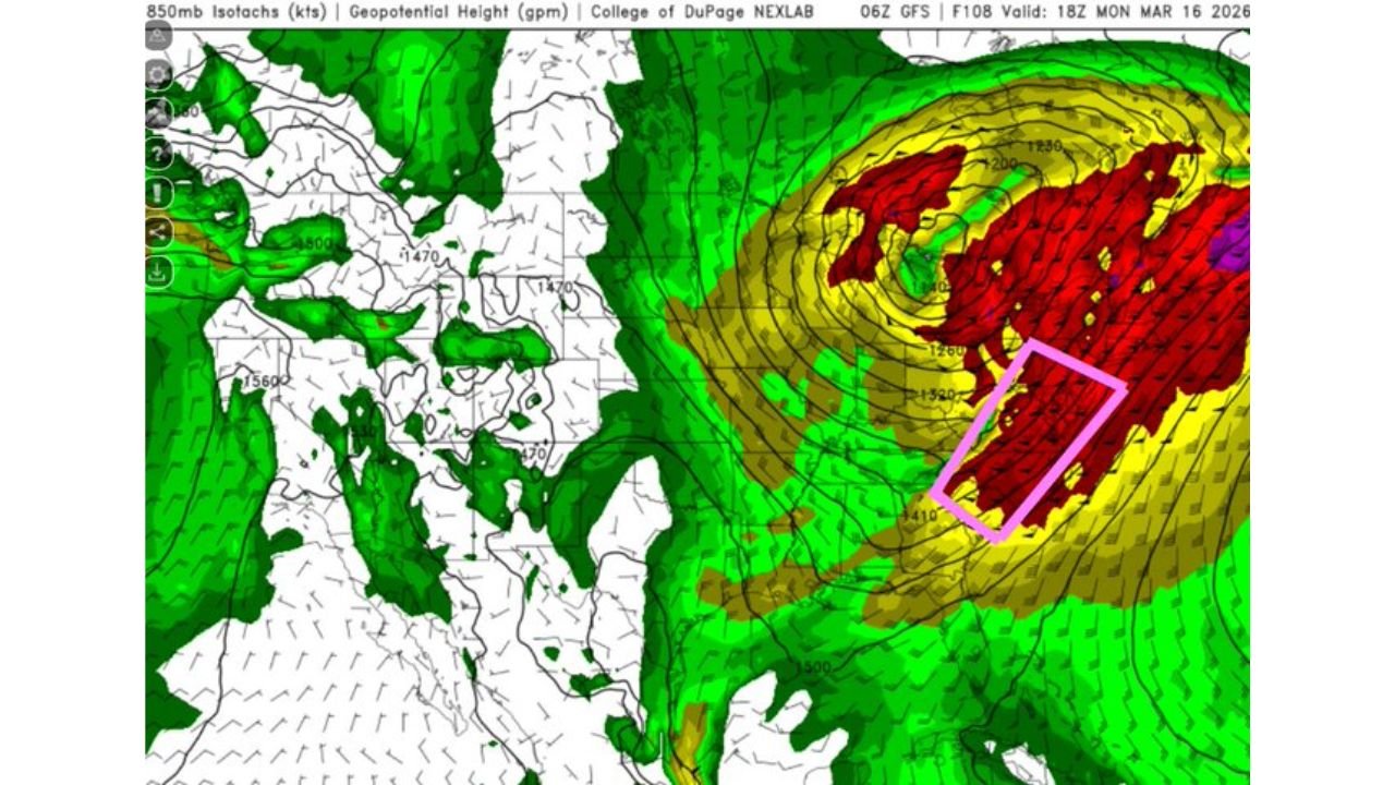
At 850mb, a strengthening low-level jet is forecast to surge northward from the Gulf of Mexico into Louisiana, Mississippi, and Alabama. This feature is critical for:
- Transporting rich moisture inland
- Enhancing wind shear
- Increasing tornado potential
The alignment of both mid-level and low-level wind fields suggests a strongly sheared environment favorable for organized severe storms.
Instability Building Along the Gulf Coast
Surface-based instability appears concentrated across southern Louisiana, southern Mississippi, southern Alabama, and into the Florida Panhandle.
Moisture return from the Gulf is evident in forecast dewpoint projections, with higher values pushing inland ahead of the approaching system. When combined with strong wind fields, this creates an environment supportive of:
- Damaging straight-line winds
- Large hail
- Tornadoes, potentially including stronger tornadoes if discrete storms can develop
The highlighted corridor includes cities such as:
- New Orleans
- Baton Rouge
- Mobile
- Biloxi
- Pensacola
- Montgomery
A Classic High-Shear Setup
The overlap of strong wind shear and instability is what makes this event particularly concerning.
Wind profiles show pronounced directional and speed shear through the lowest levels of the atmosphere. When storms form in this kind of environment, they can quickly organize into supercells or embedded rotating structures within a larger line.
Forecasters will be closely monitoring whether storms remain more linear or whether discrete cells develop ahead of the main line. Discrete supercells would increase tornado potential.
Timing: Monday
The primary window for severe weather appears to be Monday, with storms developing and intensifying as the upper-level energy swings eastward.
While details will continue to evolve, the setup resembles past early-spring severe weather events across the Deep South — the kind that can produce widespread wind damage and isolated tornadoes.
Preparedness is Key
Given the strength of the jet stream and the moisture return in place, residents across Louisiana, Mississippi, Alabama, and the Florida Panhandle should:
- Monitor forecast updates closely
- Ensure multiple ways to receive weather warnings
- Review severe weather safety plans
This is the first time in many months that the region has seen such a dynamically strong setup aligned with Gulf moisture. As refinements continue, confidence in specific impacts will increase.
For continuing coverage of significant weather events across the country, stay with ChicagoMusicGuide.com.