
Severe Storm System Triggers Tornado Threat Across Mississippi, Alabama, and Tennessee as SPC Highlights Ongoing Risk
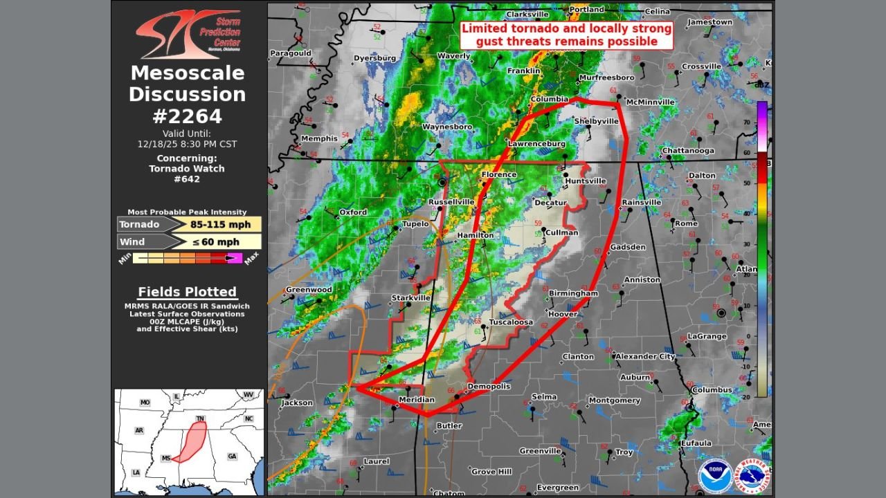
MISSISSIPPI, ALABAMA & TENNESSEE — A fast-moving line of thunderstorms is sweeping across Mississippi, Alabama, and Tennessee this evening, bringing limited tornado potential, damaging wind gusts, and rapidly evolving severe weather conditions. The Storm Prediction Center (SPC) issued Mesoscale Discussion #2264, in effect until 8:30 PM CST, highlighting areas under Tornado Watch #642 where brief tornadoes and strong winds remain possible.
Large portions of all three states are experiencing active convection, with radar signatures showing embedded rotation and bowing segments capable of producing 85–115 mph tornado intensities and wind gusts up to 60 mph.
Where the Greatest Impacts Are Expected
Mississippi
Communities around Meridian, Butler, Columbus, Greenwood, Starkville, and Oxford are positioned along the southern flank of the severe line. Storm cells in these regions continue to produce strong winds and pockets of rotation—conditions favorable for quick-developing tornadoes.
Alabama
Northern and central Alabama face the highest concentration of enhanced rotational tracks, including:
- Tuscaloosa
- Birmingham & Hoover
- Cullman
- Huntsville
- Gadsden
The SPC notes that locally strong wind signatures and sustained shear could support brief tornado touchdowns, particularly near boundaries where instability persists.
Tennessee
Communities in southern Tennessee—including Lawrenceburg, Columbia, Shelbyville, and Waynesboro—are under the influence of the advancing line. These areas remain at risk as storms track northeast with strong inflow and elevated wind fields.
SPC Analysis: Why the Tornado Threat Persists
The mesoscale discussion indicates:
- Moderate shear profiles supporting storm organization
- Pockets of instability (MLCAPE) feeding embedded rotation
- A strong squall line accelerating northeastward
- Potential for brief, fast-moving tornadoes, even as instability slowly diminishes
The overall threat is described as limited but still active, with the atmosphere supportive of spin-ups along the leading edge of the thunderstorm line.
Hazards Residents Should Prepare For
- Brief tornadoes forming quickly with little warning
- Damaging wind gusts approaching 60 mph
- Sudden drops in visibility due to heavy rain
- Downed trees and power outages
- Fast storm movement reducing reaction time
Residents are strongly urged to keep weather alerts active, avoid travel when possible, and immediately seek shelter if a warning is issued.
What’s Next?
This storm system continues marching east, and the SPC may issue additional updates or watches depending on storm evolution.
ChicagoMusicGuide.com will monitor the situation closely and provide new information as warnings are issued or conditions change.
Stay weather-aware, stay prepared, and check back for more updates from ChicagoMusicGuide.com.