
Severe Storm Threat Expands Across Illinois, Indiana and Ohio Thursday With Risk of Significant Large Hail and Supercell Development
OHIO — A developing storm system is setting the stage for scattered severe thunderstorms across portions of Illinois, Indiana and Ohio on Thursday, March 26, with forecasters highlighting the potential for significant large hail as the primary hazard.
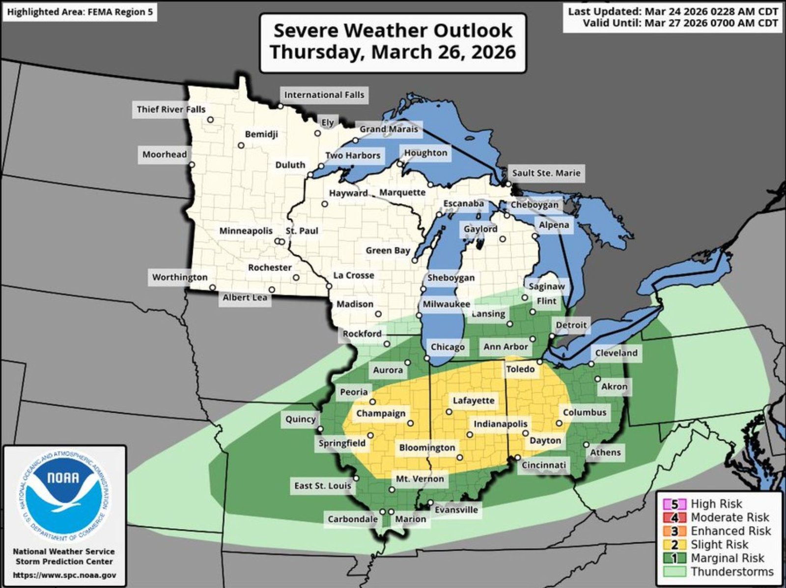
The latest Severe Weather Outlook places a Slight Risk (Level 2 of 5) across a broad corridor stretching from central Illinois through much of Indiana and into western and central Ohio. Surrounding areas remain under a Marginal Risk, while a more focused zone within the Slight Risk highlights the greatest probability for impactful storms.
Slight Risk Zone Covers Major Cities
The Slight Risk area includes key population centers such as:
- Springfield, Champaign and Peoria, Illinois
- Indianapolis, Bloomington and Lafayette, Indiana
- Dayton and Columbus, Ohio
Chicago and northern Illinois sit closer to the northern edge of the thunderstorm zone, with lower probabilities compared to central and southern portions of the state.
Supercell Structure Possible
Forecast discussions indicate Thursday may favor supercell-type thunderstorms, which are known for their ability to produce large hail, damaging winds and isolated tornadoes.
While the tornado threat remains uncertain at this time, the environment appears supportive of organized rotating storms. Additional refinement of that risk is expected as updated data becomes available.
Primary Concern: Significant Large Hail
The outlook highlights the possibility that some storms could produce very large hail, potentially reaching severe criteria or higher in the most intense cells. The greatest hail potential appears centered across:
- Central and southern Indiana
- Eastern Illinois
- Western Ohio
This corridor aligns with the hatched area on the probability graphic, indicating an elevated chance for more intense severe weather reports within 25 miles of any given point.
Damaging Wind Risk Also Present
In addition to hail, scattered storms may produce damaging wind gusts, especially if storms merge into short lines or clusters later in the day.
Localized power outages and tree damage would be possible in the strongest wind cores.
Timing and Updates
The outlook is valid through early Friday morning, March 27, with storms expected to develop Thursday afternoon and evening as instability increases and upper-level energy moves across the region.
Residents across Illinois, Indiana and Ohio are encouraged to monitor forecast updates closely as details regarding storm timing and tornado potential become clearer.
ChicagoMusicGuide.com will continue tracking Thursday’s severe weather setup as new information becomes available.