
Severe Storms With Large Hail and Possible Tornadoes Target Missouri, Arkansas, Illinois and Indiana as SPC Issues Mesoscale Discussion for Ozarks Region
SPRINGFIELD, MISSOURI — The Storm Prediction Center (SPC) has issued a Mesoscale Discussion covering portions of the Ozarks into the lower Ohio River Valley, warning that severe thunderstorms capable of producing large hail and isolated tornadoes may continue across the region through roughly 9 PM CST.
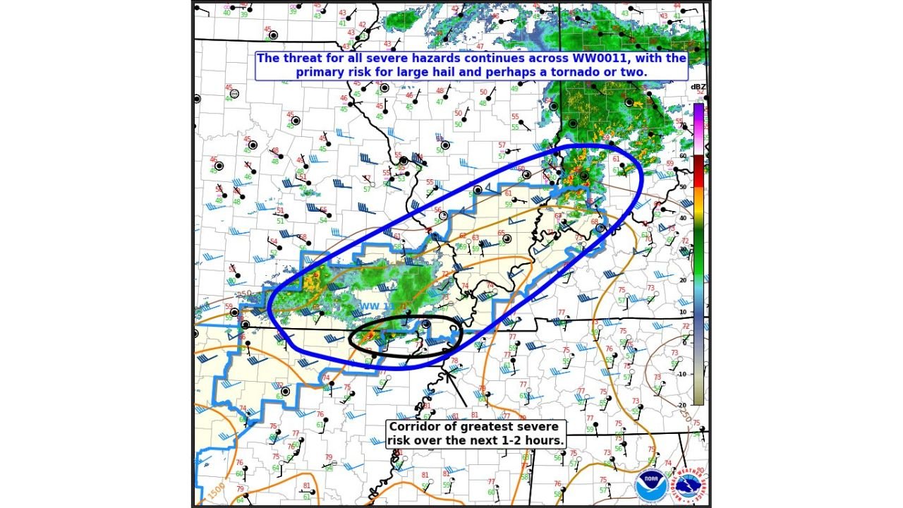
The discussion highlights an active corridor stretching from southern Missouri into northern Arkansas and extending northeast toward southern Illinois and parts of Indiana, where storms are expected to persist for the next several hours.
Meteorologists say the primary severe threat will be large hail, though atmospheric conditions could also support a tornado or two if storms remain isolated and able to rotate.
Corridor of Greatest Severe Risk From Missouri Into Arkansas
Weather data shows the highest severe storm potential currently centered over southern Missouri and northern Arkansas, where instability and strengthening winds with height are supporting active thunderstorms.
Forecasters note that storms within this corridor are capable of producing:
- Large hail between 1.0 and 1.75 inches in diameter
- Damaging wind gusts between 55 and 70 mph
- Isolated tornadoes
This area includes cities such as Springfield, Missouri; Branson, Missouri; and Harrison, Arkansas, where storms could maintain intensity over the next several hours.
Meteorologists emphasize that isolated supercells may be able to persist longer in this zone, especially if storms avoid merging into large clusters.
Atmospheric Conditions Favor Strong Hail-Producing Storms
According to the SPC analysis, storms currently have sufficient atmospheric instability combined with strengthening winds with height, a combination that promotes strong updrafts capable of producing large hail.
These conditions are particularly favorable for supercell thunderstorms, which are storms that rotate and often produce the most intense severe weather.
Experts say storms that remain isolated have the best chance to strengthen, allowing hailstones to grow larger before falling to the ground.
If storms merge into clusters, however, the threat may shift more toward heavy rain and gusty winds rather than significant hail or tornadoes.
Tornado Potential Depends on Storm Isolation
While hail is the primary concern, meteorologists say tornado potential cannot be ruled out, particularly if storms remain discrete.
Surface winds across the region are expected to increase and turn more with height, a process known as wind shear, which can enhance storm rotation.
If new storms develop and remain separated from other cells, they could tap into this rotational environment and briefly produce tornadoes.
Forecasters say the tornado risk remains relatively limited, but one or two tornadoes are possible within the strongest storms.
Severe Storm Threat Extending Toward Southern Illinois and Indiana
Farther northeast into southern Illinois and parts of Indiana, the atmosphere is somewhat more stable, which may reduce the intensity of storms.
However, meteorologists say warm air riding over a boundary in the region may still allow thunderstorms to continue producing isolated severe hail for a time.
Cities in this region that could see storm impacts include:
- Carbondale, Illinois
- Marion, Illinois
- Evansville, Indiana
- Paducah, Kentucky
While tornado risk appears lower here, isolated severe hail remains possible as storms move northeast.
SPC Monitoring Storm Evolution Across the Region
The Mesoscale Discussion #134 issued by the Storm Prediction Center indicates that the severe threat will continue across Severe Thunderstorm Watch #11, covering parts of the Ozarks and the lower Ohio Valley.
Meteorologists say the corridor of greatest severe risk over the next one to two hours remains centered from northern Arkansas into southern Missouri, where storms are currently most intense.
Forecasters will continue analyzing radar trends, atmospheric instability, and storm organization to determine whether additional watches or warnings are needed as storms move northeast.
While conditions may gradually become less favorable farther north and east, strong thunderstorms could still produce hazardous weather across several states during the evening hours.
Residents across Missouri, Arkansas, southern Illinois, and Indiana are encouraged to stay weather aware as storms move through the region.
For continued updates on severe weather alerts, storm developments, and regional weather coverage, follow the latest reports at ChicagoMusicGuide.com.