
Severe Thunderstorm Warning Issued for Idaho and Washington as Destructive 80 MPH Winds Threaten Lewiston, Pullman, and Moscow
IDAHO & WASHINGTON — A life-threatening severe thunderstorm warning was issued early Wednesday morning for several communities across northwestern Idaho and southeastern Washington, including Lewiston (ID), Pullman (WA), and Moscow (ID).
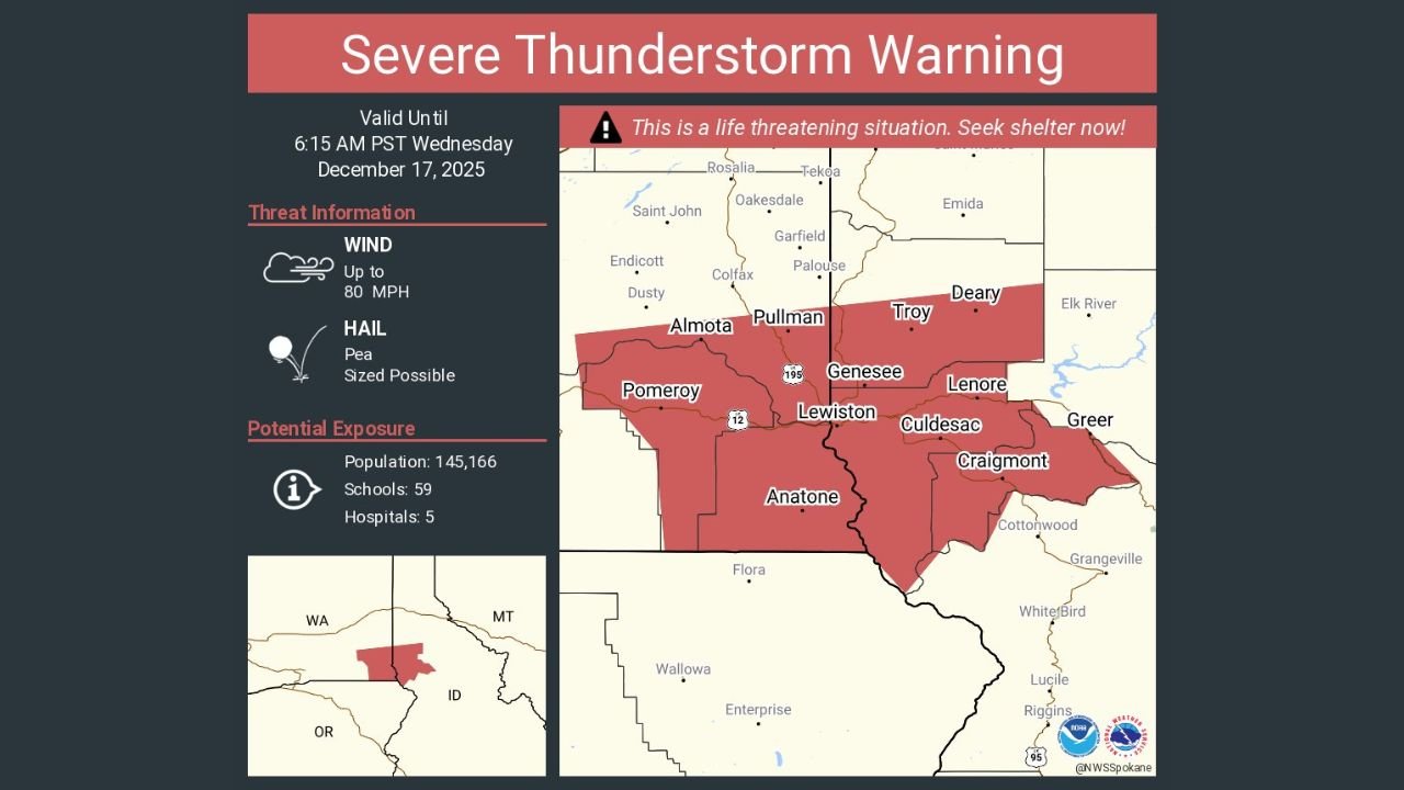
A Dangerous Early-Morning Storm Threatens Communities in Idaho and Washington
The National Weather Service warned that this rapidly moving storm is capable of producing destructive wind gusts up to 80 mph, making it one of the most dangerous severe weather events to affect the region this late in the year.
The warning is in effect until 6:15 AM PST Wednesday, December 17, 2025, and includes a broad zone of cities and towns across the Palouse region.
Threat Information: Destructive Winds and Possible Hail
According to the NWS Spokane office, the primary hazards include:
- Wind: Up to 80 MPH, strong enough to down trees, damage roofs, and cause widespread power outages.
- Hail: Pea-size hail possible as the storm’s core moves through.
This storm has been labeled a life-threatening situation, and residents in the warning area were urged to seek shelter immediately.
Cities affected include:
- Lewiston, Pullman, Moscow, Genesee, Troy, Pomeroy, Almota, Craigmónt, Lenore, Culdesac, Anatone, and Greer.
High Population Exposure Across Multiple Counties
The affected region includes:
- Population: 145,166
- Schools: 59
- Hospitals: 5
The combination of high population density in Lewiston and the university community in Pullman/Moscow significantly raises the potential impact if the storm produces expected wind speeds.
Emergency managers warn that travel may become dangerous, particularly along US-195 and US-12, where wind damage and falling debris are likely.
Why This Storm Is Unusual for December
Severe thunderstorms producing 70–80 mph wind gusts are extremely rare in the Inland Northwest during the winter season.
The atmospheric setup behind this storm resembles early-fall dynamics, driven by:
- A strong Pacific jet stream
- A rapidly strengthening low-pressure center
- Unseasonably warm air ahead of the system
These ingredients created a powerful line of thunderstorms capable of widespread wind damage — a phenomenon more typical of spring or early summer.
What Residents Should Do Right Now
Officials emphasize:
- Take shelter indoors immediately
- Stay away from windows
- Secure outdoor items if time permits
- Avoid driving until the warning expires
- Prepare for possible power outages
More updates will be issued by the National Weather Service as the storm continues tracking northeast.
Stay with ChicagoMusicGuide.com for ongoing weather updates, storm coverage, and the latest alerts affecting communities nationwide.