
Severe Weather Alert: Enhanced Risk for Tornadoes, Giant Hail, and 60+ MPH Winds From Texas and Oklahoma to Missouri and Illinois Friday
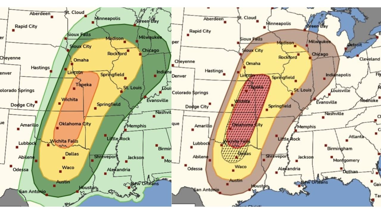
ILLINOIS — The Storm Prediction Center (SPC) has issued an Enhanced Risk for severe weather on Friday stretching from the Southern Plains into the Mid-Missouri Valley, signaling the potential for tornadoes, very large hail, and damaging winds across multiple states including Texas, Oklahoma, Kansas, Missouri, and parts of Illinois.
Meteorologists warn that the developing system could bring multiple severe weather hazards, including some strong tornadoes, hail larger than 2 inches, and wind gusts exceeding 60 miles per hour as storms organize and potentially form a powerful squall line later in the day.
The risk area extends from central and northern Texas through Oklahoma and Kansas and into Missouri and portions of the Midwest, placing millions of residents in the path of a potentially volatile spring storm setup.
Tornado and Supercell Storm Threat Across the Southern Plains
Forecasters say the greatest tornado potential Friday afternoon will likely develop across the Southern Plains, particularly in areas stretching from north-central Texas through central and eastern Oklahoma into southern Kansas.
Cities located within this higher-risk corridor include:
- Dallas, Texas
- Wichita Falls, Texas
- Oklahoma City, Oklahoma
- Wichita, Kansas
- Topeka, Kansas
Meteorologists expect supercell thunderstorms to develop in this region during the afternoon, where atmospheric conditions may support strong rotating storms capable of producing tornadoes and very large hail.
The Storm Prediction Center specifically notes that some tornadoes could be strong, which typically indicates storms capable of producing significant damage if they develop and remain isolated long enough to intensify.
Giant Hail and Damaging Winds Also Possible
In addition to the tornado risk, forecasters highlight the potential for large hail exceeding 2 inches in diameter, which can cause damage to vehicles, homes, and crops.
These hail-producing storms may initially form as discrete supercells, but meteorologists say they could later merge into a larger storm complex or squall line moving east across the Plains.
As storms begin to organize into a line, the primary hazard may shift toward widespread damaging wind gusts exceeding 60 miles per hour.
Cities that could experience strong wind impacts later in the evening include:
- Springfield, Missouri
- St. Louis, Missouri
- Rockford, Illinois
- Chicago, Illinois
- Omaha, Nebraska
- Lincoln, Nebraska
Forecasters say this transition from isolated storms to a line of storms is common in spring severe weather events, often bringing broader areas of damaging winds.
Severe Storm Corridor Extends Into Missouri and the Midwest
As storms move northeast during the evening hours, the severe weather threat is expected to expand into the Mid-Missouri Valley and parts of the Midwest.
The risk area shown in the forecast includes Missouri, eastern Kansas, southern Iowa, and portions of Illinois, including the Chicago metropolitan area.
Although the tornado threat may gradually decrease as storms move north and east, damaging winds and hail may remain significant hazards.
Meteorologists say areas such as Springfield, Missouri; St. Louis; Peoria; and Rockford could see strong thunderstorms if the storm system maintains strength overnight.
Squall Line Could Intensify Friday Evening
One of the key concerns among meteorologists is the possibility that storms will merge into a powerful squall line during the evening hours, which could sweep east across several states.
When storms organize into this type of structure, they often produce long stretches of damaging winds capable of knocking down trees and power lines.
Forecasters say this scenario could bring widespread wind damage across the central United States Friday night, especially if the line strengthens as it moves east.
Severe Weather Season Arrives Across the Central United States
The developing system is another sign that spring severe weather season is beginning across the central United States, where the collision of warm Gulf moisture and powerful atmospheric systems from the west often produces dangerous thunderstorms.
Meteorologists emphasize the importance of having a severe weather safety plan in place, particularly in areas within the Enhanced Risk zone.
Residents are encouraged to ensure they have multiple ways to receive weather alerts, including weather apps, NOAA weather radios, and emergency notifications.
As conditions evolve, additional severe thunderstorm watches or tornado watches may be issued across the Plains and Midwest.
For the latest updates on severe weather threats, Midwest storm systems, and regional forecasts affecting Chicago and surrounding areas, visit ChicagoMusicGuide.com.