
Severe Weather Threat Expands March 9–10 Across Texas, Oklahoma, Arkansas and Missouri as Powerful Trough Taps Gulf Moisture
UNITED STATES — A strengthening upper-level trough is expected to sweep through the central and southern Plains on March 9–10, setting the stage for a potentially significant severe weather episode stretching from Texas and Oklahoma into Arkansas and Missouri, with impacts possibly extending toward the Mid-Mississippi Valley.
Forecast guidance highlights a classic early-spring setup: strong wind shear aloft overlapping with a rapidly returning, moisture-rich Gulf airmass.
Upper-Level Energy Targets the Southern and Central Plains
The projected upper-air pattern shows a pronounced dip in the jet stream digging into the Southwest before ejecting into the Plains.
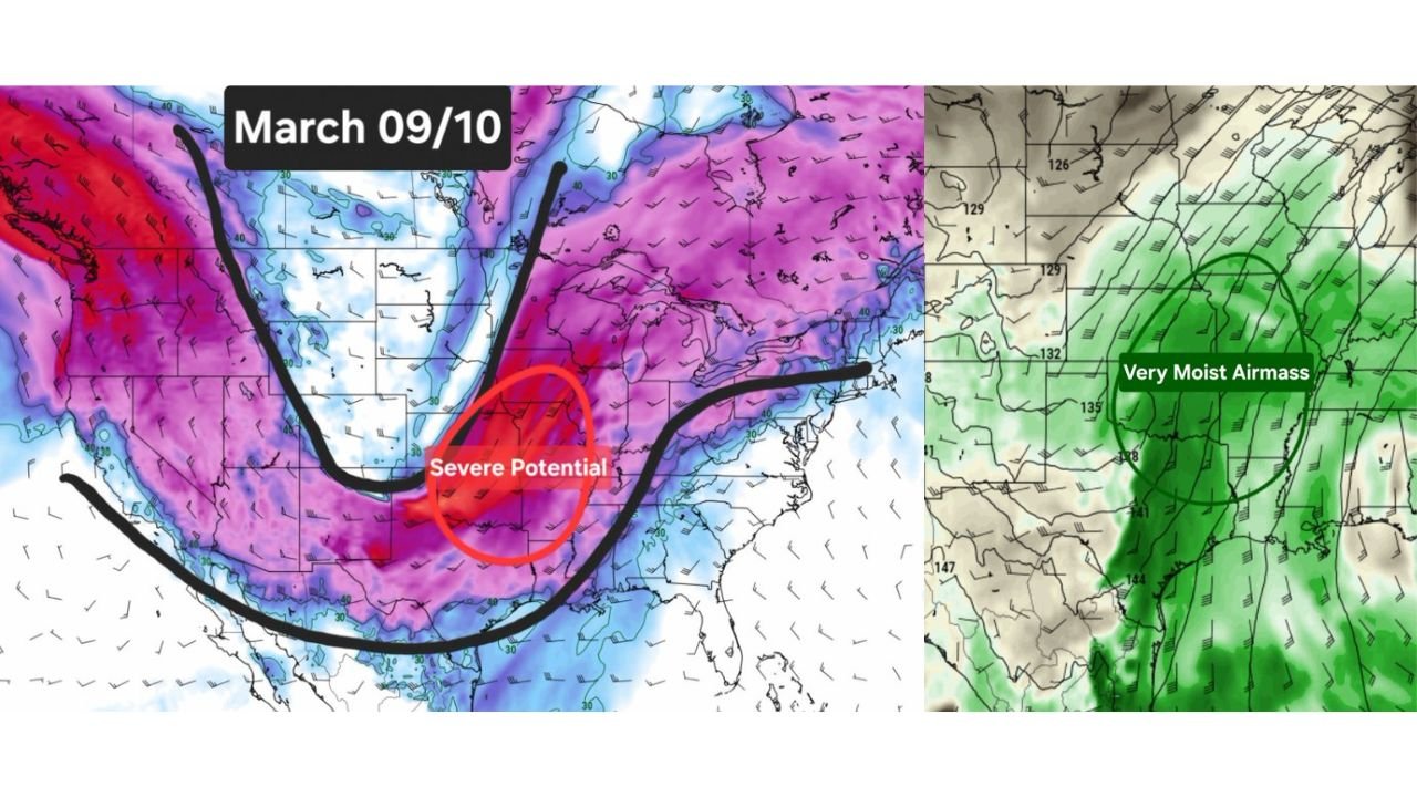
The corridor most strongly highlighted for severe potential includes:
- North Texas
- Central and eastern Oklahoma
- Western and central Arkansas
- Southern Missouri
This zone sits directly beneath strengthening upper-level winds — a key ingredient for organized severe thunderstorms.
When trough energy ejects eastward, lift increases dramatically, enhancing the risk for:
- Supercell thunderstorms
- Damaging wind gusts
- Large hail
- Tornado potential
Deep Gulf Moisture Surges North
At the same time, a very moist airmass is forecast to surge northward from the Gulf of Mexico.
The moisture plume is centered across:
- East Texas
- Arkansas
- Western Tennessee
- Mississippi
- Extending northward toward Missouri and southern Illinois
This combination — strong upper-level dynamics and deep low-level moisture — is a classic severe weather signal during early March transitions.
The overlap zone between shear and moisture appears most pronounced across Oklahoma into Arkansas and southern Missouri, making that corridor especially important to monitor.
Storm Mode and Timing Still Evolving
Forecast discussions emphasize that this is part of a broader active pattern, meaning multiple systems may move through the region during early to mid-March.
However, trends will need monitoring as:
- The exact track of the trough will determine where the highest risk sets up
- Small shifts east or west could move the core threat zone
- Timing will affect storm intensity and coverage
Early signals suggest the March 9–10 window carries the strongest severe potential within this setup.
Implications for the Midwest and Chicago Region
For Chicago and northern Illinois, this system likely tracks to the south and southwest of the city initially. However:
- If the storm system strengthens and lifts northeast
- Or if the moisture plume extends farther north
Parts of the broader Midwest could see increasing thunderstorm activity.
At minimum, the evolving pattern supports:
- More frequent rain chances
- Increasing humidity compared to recent weeks
- A transition into a more springlike storm regime
A Classic Early-Spring Severe Setup
This configuration reflects a seasonal shift:
- Strong Pacific energy moving inland
- Desert Southwest troughing
- Gulf moisture returning northward
- Enhanced wind shear across the Plains
It’s the type of pattern that often signals the unofficial start of severe weather season across the southern Plains.
While confidence is growing in an active March, exact details will become clearer as higher-resolution guidance comes into range.
For now, residents across Texas, Oklahoma, Arkansas, Missouri, and surrounding states should stay weather-aware heading into the March 9–10 timeframe.
Stay tuned to ChicagoMusicGuide.com for continued updates as this evolving severe weather threat develops.