
Severe Wind Event in Idaho Produces Multiple 80+ mph Gusts as Destructive Thunderstorms Sweep the Region
IDAHO — A powerful wind event struck parts of Idaho on Wednesday morning, bringing destructive thunderstorms, damaging gusts over 80 mph, and widespread wind reports across multiple counties.
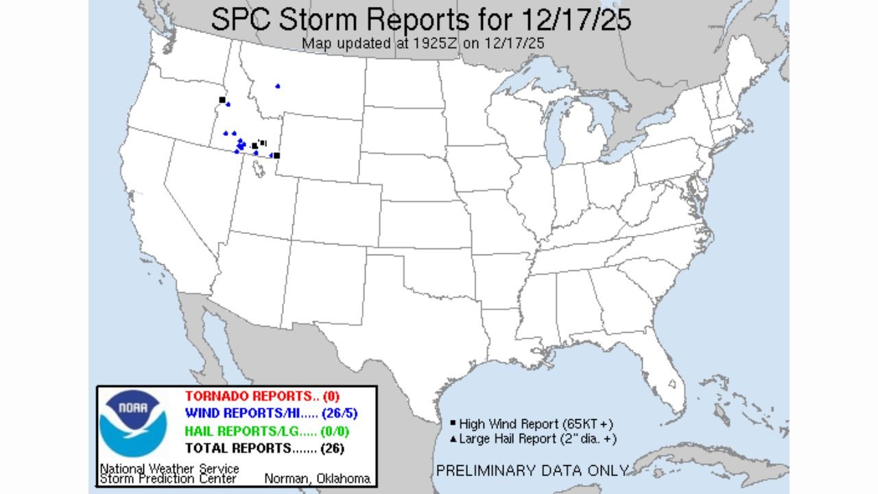
According to updated storm data from the NOAA Storm Prediction Center, at least 26 wind reports were submitted across the state on December 17, highlighting the severity of the early-morning event.
Meteorologists described the setup as unusually intense for this time of year, with fast-moving storms generating severe-level wind gusts and additional strong non-thunderstorm winds behind the main line of storms.
Thunderstorms Produced Several Significant Wind Reports Over 80 mph
Radar-indicated severe thunderstorms moved across western and central Idaho shortly after sunrise, producing:
- Multiple high-end wind gusts exceeding 80 mph
- Widespread tree damage
- Localized power outages
- Hazardous travel conditions
The SPC storm map shows clusters of severe wind reports concentrated in southern and western Idaho. While no tornadoes or hail were reported, the strength and number of damaging wind gusts made this a notable regional event.
Non-Thunderstorm Winds Added to the Damage After Storms Passed
Even after the thunderstorms weakened, Idaho continued to experience strong gradient winds, which produced additional impacts throughout the late morning and afternoon.
These non-thunderstorm winds contributed to:
- Downed branches
- Blowing dust in open areas
- Continued stress on weakened infrastructure
Forecasters noted that this two-phase wind event — severe thunderstorm winds followed by strong post-frontal winds — significantly increased the overall damage footprint.
SPC Confirms 26 Total Wind Reports From Idaho Alone
The preliminary SPC summary for December 17 lists:
- 0 tornado reports
- 26 wind reports (5 significant)
- 0 hail reports
The concentration of blue and dark-blue markers on the map illustrates the geographic alignment of the strongest wind damage across Idaho’s valleys and foothill regions.
More Wind Events Possible as Pattern Remains Active
Meteorologists warn that the large-scale pattern driving these intense wind events — including rapid storm movement and strong jet-stream dynamics — may persist through the coming days.
Residents are urged to:
- Monitor updated NWS alerts
- Secure outdoor items
- Prepare for possible additional power outages
Stay with ChicagoMusicGuide.com for ongoing weather coverage and regional updates.