
Sharp Arctic Front to Slam Illinois With 10–12°F Temperature Drop in One Hour, Powerful Winds, and Gusty Snow Showers
ILLINOIS — A Rapidly Intensifying Cold Front Will Sweep Across the State Thursday, A very sharp Arctic cold front is forecast to surge across Illinois around lunchtime Thursday, bringing one of the most abrupt temperature drops of the season. New high-resolution HRRR model guidance shows a 10°F to 12°F fall within a single hour, accompanied by strong non-thunderstorm winds capable of producing hazardous travel and brief, sudden reductions in visibility.
Meteorologists note that the front is moving fast enough that it may develop a squall-like band of heavy rain or rapidly changing precipitation as it sweeps eastward. Once the front passes, gusty snow showers are expected through the afternoon.
Models Show a Fast-Moving Boundary With Extreme Temperature Contrast
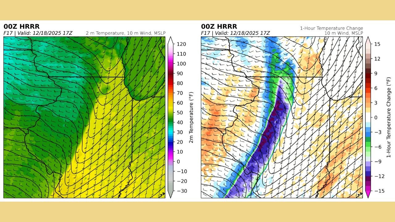
The HRRR temperature fields reveal a sharp gradient positioned directly over Illinois by early afternoon. Warm air in the mid-40s to low-50s is quickly replaced by a surge of Arctic air plunging temperatures into the 20s and 30s behind the boundary.
In the model comparison:
- Left Panel: The 2-meter temperature field shows the warm sector being overtaken rapidly by a dense, cold air mass pushing southeast.
- Right Panel: The 1-hour temperature change product displays a narrow purple corridor, indicating the region of the steepest drop — 10°F to 12°F within one hour — stretching from northern Illinois down toward central sections of the state.
This type of rapid change often produces a burst of turbulent winds as the colder, heavier air undercuts the warmer air ahead of it.
Strong Winds Expected; Localized Squall-Like Conditions Possible
Even though thunderstorms are not expected, the front itself will generate strong non-TSTM wind gusts, capable of reaching:
- 35–45 mph across much of Illinois
- Higher gusts possible near and immediately behind the frontal passage
Forecasters warn that the dramatic temperature crash could be accompanied by a brief line of heavy precipitation, potentially mimicking a low-end winter squall structure. While full squall criteria are unlikely, the rapid changes may still cause momentary whiteout bursts once colder air takes over.
Gusty Snow Showers to Follow the Front
Behind the boundary, colder air will quickly saturate the lower atmosphere, allowing scattered snow showers to develop. These showers may be brief but could produce:
- Blowing snow
- Sudden drops in visibility
- Quick dustings on untreated surfaces
Drivers should be prepared for rapidly changing conditions, especially during the early afternoon commute period.
What Illinois Residents Should Expect
- A sudden, dramatic temperature drop between late morning and early afternoon
- Strong winds throughout the day, highest immediately behind the front
- Possible brief heavy rain along the leading edge
- Gusty snow showers developing after the front passes
- Rapidly changing road and visibility conditions
Weather models continue to support a high-impact but short-duration event that will be felt statewide.
Stay Weather Ready
For Illinois residents, Thursday will bring fast-changing winter weather that may catch some people off guard. Be prepared for the sudden cold surge, reduce speed during any bursts of snow, and secure loose outdoor items ahead of the strong winds.
For more detailed weather updates and coverage, stay connected with ChicagoMusicGuide.com.