
Snowfall Rates Spike Across Northeastern North Carolina as Heavy Snow Moves North Into Hampton Roads, Virginia
UNITED STATES — A powerful winter storm impacting North Carolina and Virginia is intensifying Saturday evening as heavy snow over northeastern North Carolina spreads north into the Hampton Roads region of Virginia, prompting dangerous travel conditions, sharply reduced visibility, and rapidly snow-covered roads. Meteorologists warn that snowfall rates and bitter cold temperatures will cause conditions to deteriorate quickly through the evening hours.
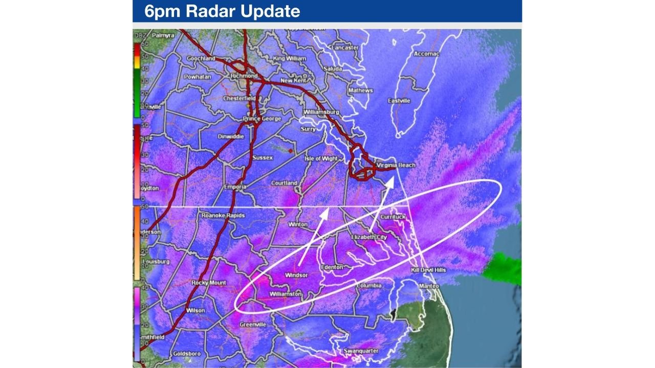
Heavy Snow Expands Across Northeastern North Carolina
Weather radar and surface observations indicate that snowfall continues to increase across northeastern North Carolina, with communities such as Elizabeth City and Currituck County already experiencing visibility dropping to one mile or less in steady snow.
Forecasters report snowfall rates of one-half inch to one inch per hour in localized bands across NE North Carolina, a pace capable of overwhelming road treatment efforts. As snow bands persist, accumulations are expected to climb rapidly, especially in areas caught beneath the most intense radar returns.
These conditions mark a dangerous transition period as snowfall intensity increases faster than crews can respond, particularly in rural and coastal communities.
Snow Bands Push North Into Hampton Roads, Virginia
Radar imagery shows the heaviest snow bands lifting northward into southside Hampton Roads, including parts of southeastern Virginia, over the next several hours. This northward expansion is expected to bring rapidly worsening travel conditions into areas that may have initially seen lighter snow.
Officials warn that the transition from wet roads to snow-covered surfaces will be abrupt, leaving little time for drivers to adjust. The movement of these intense bands increases the risk of vehicle accidents, road closures, and stranded motorists, especially during evening travel.
Cold Temperatures Accelerate Road Icing
A major factor compounding the danger is the very cold air mass in place, with temperatures already in the teens and lower 20s across much of eastern North Carolina and southeastern Virginia.
At these temperatures, snow will stick immediately upon contact, causing roads, bridges, and overpasses to become slick and hazardous within minutes. Transportation officials caution that black ice and compacted snow will make stopping distances significantly longer, even on treated roadways.
Pedestrians are also urged to use caution, as sidewalks and parking lots may quickly become icy as snowfall intensifies.
Visibility and Travel Conditions Expected to Worsen Overnight
As snow continues into the night, visibility may drop further, particularly in heavier bands where blowing snow is present. Drivers could encounter near-whiteout conditions at times, especially in open or coastal areas exposed to wind.
Emergency management agencies across North Carolina and Virginia urge residents to avoid unnecessary travel, keep emergency supplies in vehicles, and monitor local advisories. Officials stress that even short trips may become dangerous quickly as conditions evolve.
Ongoing Impacts as Storm Continues Northward
The winter storm is expected to maintain its intensity as it continues affecting the Mid-Atlantic region, with lingering impacts extending into early Sunday. Snow-covered roads, delayed emergency response times, and potential power disruptions remain possible as the storm progresses.
Residents across northeastern North Carolina and southeastern Virginia are encouraged to stay indoors if possible, check on vulnerable neighbors, and prepare for continued hazardous winter conditions overnight and into Sunday morning.
As this winter storm tightens its grip on North Carolina and Virginia, rapidly changing conditions will demand caution and preparation. For continued updates on severe weather developments, regional impacts, and safety guidance, visit ChicagoMusicGuide.com.