
South Carolina and Georgia Face Hazardous Cold as Coastal Storm Raises Weekend Snow Risk
UNITED STATES — A period of hazardous cold weather combined with the potential development of a coastal storm system is raising concerns for South Carolina and Georgia this weekend, with forecasters warning that winter weather impacts, including possible snow, could affect parts of the Southeast. While confidence remains limited on exact timing and totals, the setup is enough for officials to urge residents to begin preparations and closely monitor forecast updates.
Hazardous Cold Air Sets the Stage Across the Southeast
Very cold Arctic air is already entrenched across much of the eastern United States, and that cold will remain firmly in place as the weekend approaches. For South Carolina and Georgia, this means temperatures cold enough to support winter precipitation should moisture move in from the coast.
Forecast guidance highlights that hazardous cold conditions alone pose risks, including dangerous wind chills, stress on heating systems, and increased vulnerability for those without adequate shelter. The persistence of the cold is a key factor, as it allows even a marginal storm system to produce wintry impacts farther south than usual.
Meteorologists note that this cold air mass is unusually deep for late January, increasing the chances that precipitation falls as snow rather than rain if conditions align.
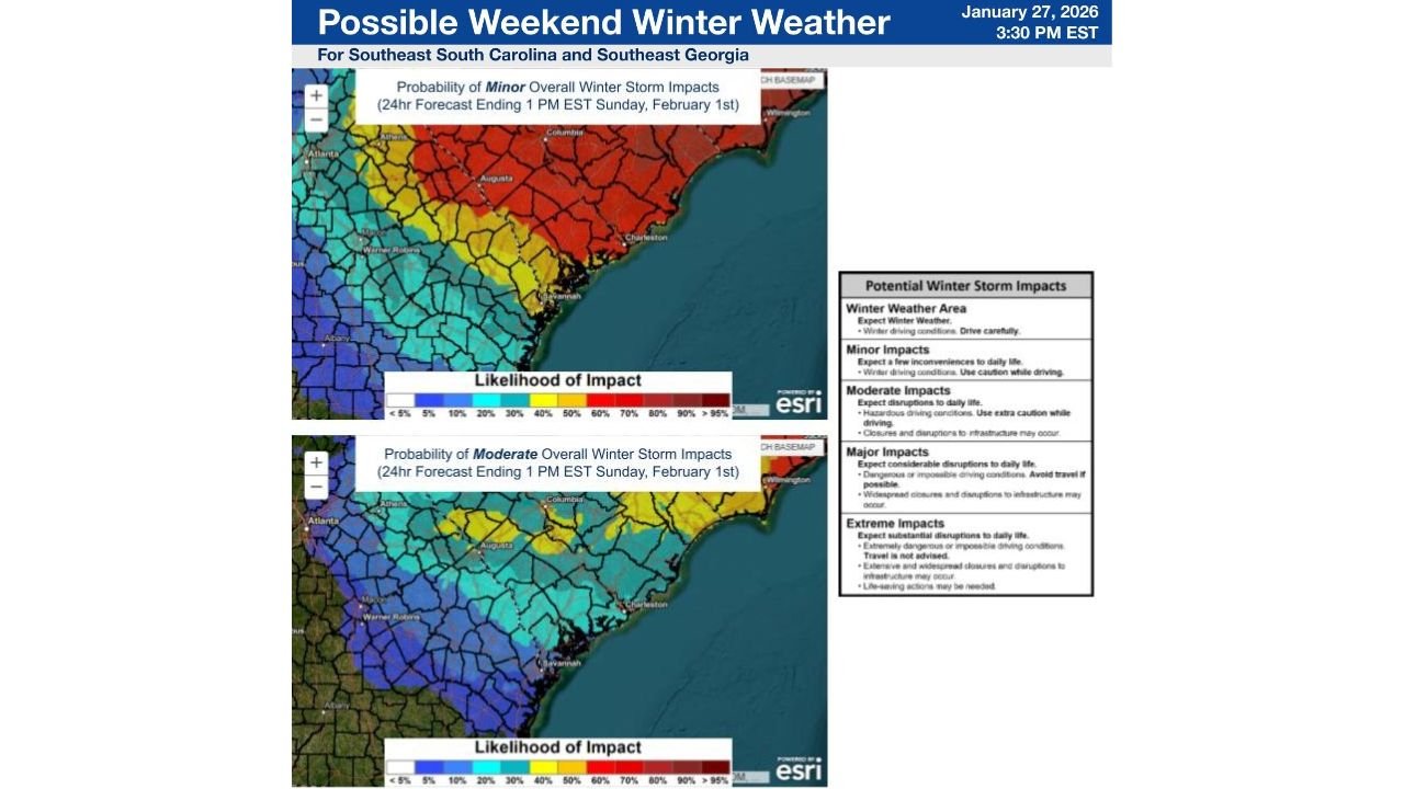
Coastal Low Could Trigger Winter Weather
An area of low pressure is expected to develop offshore of the Southeast coast this weekend. As it forms, the system could pull moisture inland across southeast Georgia and southeast South Carolina, setting up the potential for winter weather.
Forecasters emphasize that the proximity of the low-pressure system to the coast will be critical. A track closer to shore would increase the chance for measurable precipitation inland, while a farther-offshore path could limit impacts mainly to coastal areas.
At this time, the most likely scenario points to minor winter weather impacts, but even light snow or mixed precipitation could create issues in regions that are not accustomed to winter driving conditions.
Snow Is the Most Likely Winter Precipitation Type
Given the depth and strength of the cold air in place, snow is currently the most likely precipitation type if winter weather develops. This is notable for parts of Georgia and South Carolina, where snow events are relatively rare and can cause outsized disruptions.
Even small accumulations can lead to slick roads, reduced visibility, and travel delays, especially during overnight and early-morning hours. Bridges and overpasses would be particularly vulnerable due to rapid icing.
Forecasters caution that confidence remains low regarding exact snowfall amounts, but the atmospheric setup warrants close attention.
Critical Timing: Saturday Morning Through Sunday Midday
The main window of concern currently spans from early Saturday morning through midday Sunday. During this period, the combination of cold air and potential precipitation could produce the greatest impacts.
If the coastal low strengthens and tracks favorably, conditions could deteriorate quickly, particularly in inland portions of southeast Georgia and southeast South Carolina. Travelers with weekend plans should be prepared for rapidly changing weather conditions.
Because timing remains uncertain, officials stress the importance of checking updated forecasts frequently as the weekend approaches.
Uncertainty Remains High, but Preparedness Is Key
Despite clear signals of cold air and storm potential, considerable uncertainty remains regarding the exact placement, timing, and intensity of any winter weather. Small shifts in the storm track could mean the difference between dry but cold conditions and impactful winter weather.
Forecasters describe current confidence as low, especially concerning precipitation extent and magnitude. However, the potential impacts are significant enough that residents are urged not to dismiss the threat.
Preparing now — by reviewing travel plans, ensuring vehicles and homes are winter-ready, and staying informed — can help reduce risks if conditions worsen.
What Residents Should Do Now
With hazardous cold already in place and winter weather possible this weekend, residents across South Carolina and Georgia should take proactive steps. This includes protecting exposed pipes, ensuring adequate heating, and checking on vulnerable neighbors and family members.
Those planning to travel should remain flexible and be prepared for delays or changing conditions, particularly during the Saturday to Sunday timeframe.
As the Southeast faces this unusual winter setup, staying alert and informed will be essential.
As this potential winter weather threat continues to evolve across South Carolina and Georgia, staying updated with reliable forecasts is crucial. For continued coverage of major weather developments and regional impacts, visit ChicagoMusicGuide.com for the latest updates.