
Southeastern New Mexico Braces for Overnight Snow Surge as Heavier Band Targets Ruidoso, Roswell, and Clovis With Up to 6 Inches
UNITED STATES — A stronger band of winter precipitation is moving across southeastern New Mexico, bringing a period of more intense snowfall rates overnight as a winter storm continues to evolve across the region. The National Weather Service office in Albuquerque warns that areas including Ruidoso, Roswell, and Clovis could see 3 to 6 inches of snow, with moderate to locally major travel impacts expected through the overnight hours and into early Sunday.
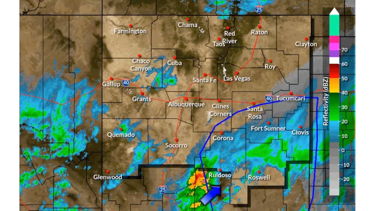
Radar imagery shows the heavier precipitation shield pushing north and northeast across the Sacramento Mountains, a setup that typically enhances snowfall rates and accumulation due to terrain effects.
Heavier Snow Band Moving Across the Sacramento Mountains
Meteorologists report that the most intense snowfall is developing as moisture is forced upslope into the Sacramento Mountains, increasing snowfall efficiency. This process is already producing heavier returns near Ruidoso, with snow expanding toward Roswell and Clovis as the night progresses.
Snowfall rates within this band may become briefly heavy, especially in elevated terrain and along key corridors south and east of Alamogordo. Accumulation on roadways is expected, particularly during periods of steady snowfall overnight.
Forecast Snow Totals and Impacted Communities
Current forecasts call for 3 to 6 inches of snow across much of southeastern New Mexico, with the highest totals favored near and east of the mountains. Communities expected to see the most significant impacts include:
- Ruidoso, where terrain-enhanced snowfall could push totals toward the higher end
- Roswell, with accumulating snow likely on roads and secondary highways
- Clovis, where snowfall may continue into the early morning hours
Even lower-end totals could still produce hazardous conditions, especially where snow compacts quickly under colder overnight temperatures.
Travel Conditions Expected to Deteriorate Overnight
Officials warn that overnight travel conditions may become dangerous, particularly on mountain roads and highways that cross higher elevations. Snow-covered and slick surfaces are likely, and visibility may be reduced during heavier snowfall bursts.
Drivers traveling late tonight or early Sunday should be prepared for:
- Snow-covered roads
- Reduced visibility during heavier bands
- Slower travel times and potential road closures
Emergency managers urge residents to delay travel if possible until conditions improve.
Why This Snowfall Could Have Locally Major Impacts
While snowfall totals may appear modest in some locations, forecasters emphasize that timing and intensity play a major role in impacts. Snow falling overnight tends to compact and freeze quickly, increasing the risk of icy conditions even after snowfall tapers.
Additionally, southeastern New Mexico does not experience frequent winter storms of this nature, meaning even moderate snowfall can lead to outsized impacts on infrastructure and travel compared to regions accustomed to regular snow events.
What to Expect After the Snow Moves Through
Snowfall intensity is expected to gradually decrease toward Sunday morning as the heavier band shifts eastward. However, lingering snow and cold temperatures may keep roads slick into the daytime hours, especially in shaded or elevated areas.
Officials recommend monitoring local forecasts and road conditions before traveling Sunday, as cleanup and melting may take time in colder locations.
As southeastern New Mexico faces this overnight winter weather surge, staying informed and prepared will be critical. For continued coverage of winter storms, snowfall impacts, and regional weather updates across the United States, visit ChicagoMusicGuide.com.