
Southern California and the Desert Southwest Expected to See Major Holiday Weather Pattern Shift With Storms Returning Next Week
LOS ANGELES, CALIFORNIA — After nearly a month of unusually warm and dry conditions across the Desert Southwest and Southern California, a significant pattern change is developing — and it’s expected to arrive just in time for the Christmas holiday period. Forecast confidence is growing that the persistent ridge keeping the region dry will weaken and shift east, allowing storms from the Pacific to dig farther south.
A Major Pattern Flip Expected Around Christmas Week
Meteorologists are increasingly confident that deeper West Coast troughing will set up next week, allowing a series of disturbances to move into California. Early projections show unsettled weather arriving around Christmas Day, possibly sooner, ending the extended stretch of dry warmth.
This shift marks the first meaningful storm threat in weeks, with impacts likely felt across Southern California, Central California, and portions of Arizona and Nevada.
Storms May Tap Into Tropical/Subtropical Pacific Moisture
Forecast guidance indicates the upcoming pattern may again connect to warmer tropical or subtropical Pacific moisture plumes, which could lead to:
- Higher snow levels initially above 7,000–8,000 feet
- Widespread rainfall statewide
- Potentially heavy precipitation in some regions
However, colder air behind each system may gradually lower snow levels, increasing the chance for accumulating mountain snowfall later into the pattern.
Storm Timing: Still Uncertain but Growing More Likely
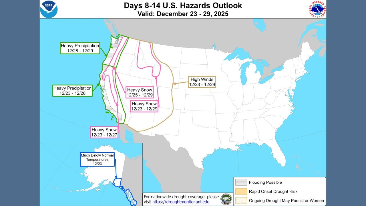
Although the first storms are still about 10 days out, multiple agencies — including NOAA and CW3E atmospheric river monitoring — show:
- Increasing probability of moisture plumes hitting California
- Elevated risks for heavy precipitation between December 23–29
- Potential for high winds in parts of the West
- Heavy snow possible across mountain ranges, including the Sierra Nevada and Southern California mountains
Confidence continues to rise that this will not be a one-off event, but rather a series of storms lasting into Christmas and potentially beyond.
Model Outlook Highlights
According to NOAA’s 8–14 day outlooks:
- Above-normal precipitation is favored along nearly the entire California coast
- Temperature trends shift cooler as the ridge weakens
- Travel across mountain passes may become increasingly difficult
CW3E atmospheric river probability maps show multiple IVT plumes aiming at California between December 21–26, reinforcing the likelihood of sustained wet conditions.
Potential Impacts Across the Region
Residents and travelers should prepare for:
- Roadway and stream flooding, especially where soils remain dry and hard
- Disrupted holiday travel, particularly through mountain passes
- Heavy mountain snow later in the pattern
- Possible high-elevation chain requirements
Conditions may worsen if multiple storms occur consecutively, which the current forecasts strongly suggest.
Mountain Travelers Should Plan Ahead
If you’re heading into the mountains for the holidays, forecasters recommend:
- Carrying chains at all times
- Preparing for rapidly changing weather
- Allowing extra travel time
- Monitoring updated forecasts daily
This developing pattern could bring the most active stretch of weather that Southern California has seen in over a month.
Have you experienced major holiday storms in past California winters? Share your thoughts and weather memories with us — and stay tuned to ChicagoMusicGuide.com for continued updates as this pattern evolves.