
Southern Kansas, Oklahoma and North Texas Face Rare Cold-Air Funnel Risk Saturday as Sunshine and Upper Low Combine
OKLAHOMA CITY, OKLAHOMA — A rare but noteworthy weather setup is taking shape for Saturday, February 14, as forecasters highlight the potential for cold-air funnel clouds or brief, weak tornadoes across southern Kansas, much of central and western Oklahoma, and the Red River Valley of Texas.
While this is not expected to be a traditional severe weather outbreak, atmospheric conditions could support isolated, low-end spin-ups during the afternoon hours.
Upper-Level Low Moves Over the Southern Plains
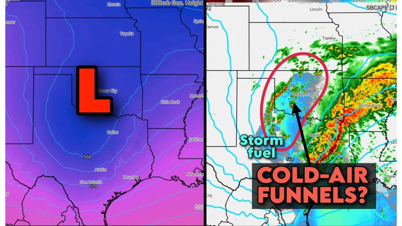
Weather maps show a pronounced upper-level low pressure system centered over the Southern Plains, with the core circulation positioned near Oklahoma and north Texas. The main cold front and organized storm complex will have already pushed east of the region by midday Saturday.
That eastward progression allows sunshine to break through, especially across central and western Oklahoma and parts of southern Kansas.
As surface heating increases under the cold core aloft, small pockets of rising air may develop — a key ingredient for cold-air funnels.
Sunshine and Cold Air Aloft Create Unusual Setup
Unlike classic spring tornado setups that rely on strong warm, moist air and significant instability, this event is driven by a colder atmosphere overhead.
As sunshine warms the surface:
- Air parcels begin rising beneath the cold upper low
- Shallow showers may develop
- Low-topped thunderstorms become possible
This type of environment can produce cold-air funnel clouds, which are typically weak and short-lived. However, if one of these funnels briefly reaches the ground, it could technically be classified as a low-end tornado (EF0, possibly EF1).
Forecast graphics highlight a corridor of scattered showers and storm “fuel” centered over Oklahoma City, extending south toward Dallas–Fort Worth and northeast toward southern Kansas.
Areas of Concern: Kansas, Oklahoma and the Red River Valley
The primary zone of interest includes:
- Southern Kansas, especially near the Oklahoma border
- Central and western Oklahoma, including the Oklahoma City metro
- The Red River Valley of Texas, north of Dallas
The radar projections show scattered, shallow convection developing during the afternoon as the upper low pivots overhead.
Because the instability is modest and storms remain low-topped, widespread damage is not anticipated. However, the cold-core environment enhances localized spin potential.
What Cold-Air Funnels Mean for Residents
Cold-air funnels are often visually dramatic but typically weak. They form beneath showers in colder upper-level environments rather than along strong supercells.
Still, safety precautions apply.
If a funnel cloud is observed nearby:
- Move indoors immediately
- Stay away from windows
- Take shelter in an interior room
Even brief EF0 or EF1 tornadoes can knock down small trees or cause minor structural damage.
Not a Classic Severe Outbreak, But Worth Monitoring
Forecasters describe the setup as “curious” rather than dangerous on a large scale. The main organized severe weather risk has already shifted east, leaving behind a destabilizing but relatively low-energy environment.
This scenario underscores how even post-frontal sunshine can occasionally create localized hazards under a cold-core low.
Residents across Kansas, Oklahoma, and north Texas should remain weather-aware Saturday afternoon, especially if scattered showers begin popping up overhead.
For continued updates on Southern Plains weather patterns, tornado risk analysis, and weekend forecast developments, visit ChicagoMusicGuide.com for the latest coverage.