
Southern Plains and Southeast Severe Weather Threat Builds for Texas, Oklahoma, Arkansas, Louisiana, Mississippi, Alabama, and Georgia This Weekend
UNITED STATES — A developing storm system is drawing close attention from forecasters as severe weather becomes increasingly likely across the Southern Plains and the Southeast, with impacts expected from Texas through Georgia between Saturday and Sunday, February 14–15. While details are still evolving, current model guidance points to a setup capable of producing damaging winds, heavy rain, and a few tornadoes, particularly as the system strengthens and moves east.
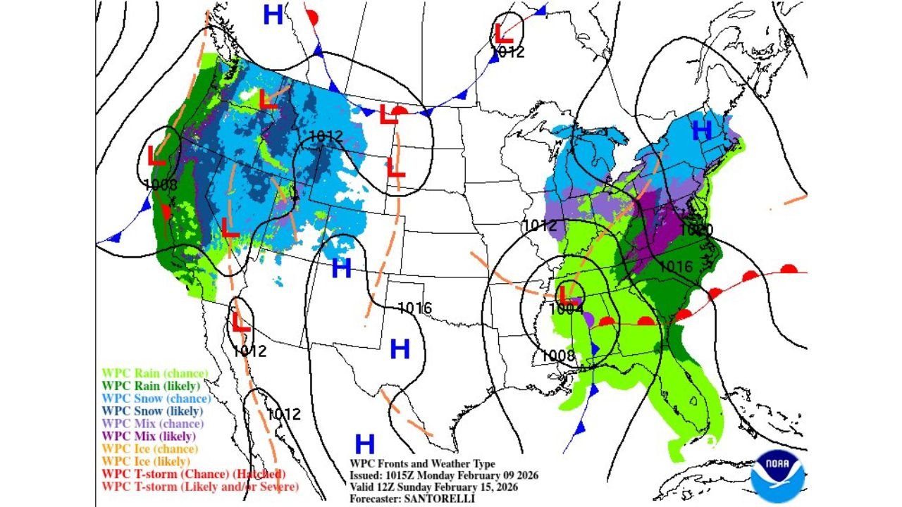
Developing Storm System Brings Multi-State Severe Risk
Forecast maps show a broad swath of precipitation expanding from Texas into Oklahoma, Arkansas, and Louisiana, then pushing toward Mississippi, Alabama, and Georgia as the weekend progresses. A deepening surface low and strong upper-level support are expected to combine with Gulf moisture, creating a favorable environment for organized thunderstorms.
At this stage, meteorologists emphasize that timing and exact placement of the strongest storms remain uncertain. However, the overall signal for severe weather is clear enough to warrant early awareness across the region. The most likely threats include strong to locally damaging wind gusts, with isolated tornadoes possible where storms can take advantage of enhanced wind shear.
Why Confidence Is Growing — Even Days Out
Longer-range guidance, including ensemble forecasts, highlights the importance of moving beyond single “yes or no” outcomes and instead focusing on probabilities and likelihoods. Even at six to seven days out, forecasters must assess how storm systems evolve beyond traditional forecast windows, especially when impacts do not conveniently stop at a set day.
This weekend’s setup is a good example. The storm system is not expected to abruptly weaken after one day; instead, it should continue evolving as it tracks east, spreading rain and thunderstorms across multiple states. That persistence is why Texas through Georgia remain in focus despite lingering uncertainty about where the worst conditions may occur.
What Residents Should Watch For This Weekend
Residents across the Southern Plains and Southeast should monitor forecasts closely as confidence improves. Key signals to watch include:
- Strengthening storms Saturday across Texas, Oklahoma, and Arkansas
- Increasing severe potential Sunday across Louisiana, Mississippi, Alabama, and Georgia
- The possibility of damaging straight-line winds
- A limited but non-zero tornado risk, especially in stronger storm clusters
- Periods of heavy rainfall that could impact travel and outdoor plans
Forecasters stress that it is too early to pinpoint exact cities or counties for the highest risk, but the multi-state nature of the system makes preparedness especially important.
Why This Matters Beyond the Weather Maps
Severe weather outbreaks in February often serve as reminders that winter is not just about cold and snow. Transitional patterns can produce high-impact storms, particularly across the Southern U.S., where warm, moist air can quickly fuel thunderstorms even in mid-winter.
As this system comes into better focus later in the week, forecast updates will refine who sees the strongest storms and when, helping communities prepare for potential disruptions.
For continued updates on this evolving weather pattern and how it may affect travel, events, and daily plans, visit ChicagoMusicGuide.com for the latest forecasts and regional weather coverage.