
Southern Plains on Alert as Late March and Early April Pattern Signals Rising Tornado Risk Across Texas, Oklahoma and Kansas
TEXAS — Forecast model trends are increasingly pointing toward a potentially active stretch of severe weather across the Southern Plains from late March into the first half of April, with signals suggesting an environment favorable for supercells and tornadoes.
Long-range ensemble guidance highlights a strengthening trough–ridge pattern developing just as peak-season thermodynamics begin to ramp up across the Plains — a combination often associated with organized severe weather outbreaks.
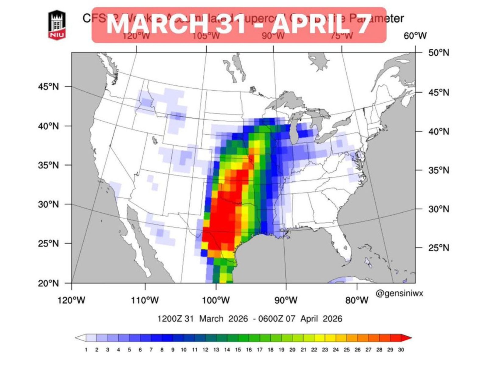
March 31 – April 7: Elevated Signal Emerging
During the March 31 through April 7 window, model projections show a concentrated corridor of enhanced severe weather parameters centered across:
- West and central Texas
- Western and central Oklahoma
- Southern and central Kansas
The highest values appear clustered near the Texas–Oklahoma border region, extending northward into Kansas. This region aligns with traditional early-season severe weather corridors where moisture return from the Gulf of Mexico meets strengthening upper-level dynamics.
April 7 – April 14: Threat Shifts and Expands
For the April 7 through April 14 timeframe, the signal remains robust but shifts slightly south and east, focusing more heavily on:
- Central and southern Texas
- Southern Oklahoma
- Portions of Louisiana and Arkansas
While the strongest model signal remains centered in Texas, broader areas of the lower Mississippi Valley begin showing increased potential compared to earlier in the period.
Pattern Setup: Why It Matters
The projected atmospheric configuration resembles a classic Plains severe weather pattern:
- A strengthening western trough
- Ridging downstream
- Increasing moisture return from the Gulf
- Favorable wind shear profiles
This setup is commonly associated with supercell development, particularly when instability overlaps with strong mid-level winds.
Although these outlooks are still weeks away and subject to change, ensemble support across multiple runs suggests this is not a fleeting signal.
Tornado Potential on the Rise?
While long-range models do not pinpoint specific tornado days, elevated supercell composite parameters across the Southern Plains imply a heightened risk window for rotating storms.
Historically, early April marks the beginning of a more active phase of severe weather season across Texas and Oklahoma, and current guidance suggests that transition may occur on schedule.
Long-Range Caution
It is important to emphasize that these projections represent broader pattern signals, not specific outbreak forecasts. Exact storm days, intensity, and location will depend on short-term atmospheric details that cannot yet be resolved.
However, residents across Texas, Oklahoma and Kansas should be aware that the first half of April may bring an uptick in severe weather chances.
ChicagoMusicGuide.com will continue monitoring long-range trends as the Southern Plains move closer to peak tornado season.