
Southern Plains See Surge in Rainfall While Western Plains Face Growing Dryness Risk Heading Into Mid-April Pattern Shift
UNITED STATES — A shifting mid-April weather pattern is expected to bring above-normal rainfall across the Southern Plains and parts of the Midwest, while a concerning trend emerges across the western Plains, where conditions may turn increasingly dry over the next two weeks. Forecast models highlight a stark divide in precipitation, with some regions receiving heavy moisture while others fall further behind.
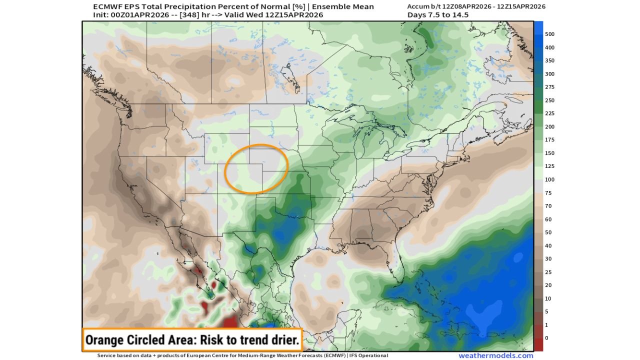
Southern Plains and Midwest Expected to Receive Above-Normal Rainfall
Forecast guidance shows a significant increase in precipitation across Texas, Oklahoma, and surrounding Southern Plains states, where rainfall totals are projected to exceed seasonal averages. This wetter pattern is expected to extend into portions of the Midwest, including areas around Missouri, Illinois, and parts of the Great Lakes region.
The concentration of moisture appears strongest across central and eastern Texas into Oklahoma, where deeper green and blue shading indicates well above-normal rainfall potential. This setup suggests repeated storm systems or prolonged rain events could impact these regions, raising the possibility of localized flooding and saturated ground conditions.
Further north, parts of the Midwest, including Illinois and neighboring states, may also benefit from increased precipitation, though totals are expected to be less intense compared to the Southern Plains. This rainfall could help stabilize soil moisture levels and support early-season agricultural conditions across the region.
Western Plains Face Increasing Risk of Dry Conditions
In contrast, the forecast highlights a growing concern across the western Plains, particularly areas spanning eastern Colorado, western Kansas, and portions of Nebraska. This region has been specifically identified as an area at risk to trend drier, with precipitation levels expected to fall below normal during this period.
The model output shows lighter shading across this zone, indicating a lack of consistent storm activity and limited moisture return. This trend is especially notable given that parts of the western Plains have already experienced below-average rainfall, increasing the risk of worsening dry conditions.
If this pattern holds, it could lead to early-season drought development, impacting agriculture, water supply, and fire risk across these states. The lack of incoming systems suggests that meaningful relief may not arrive in the short term, further compounding existing deficits.
Sharp Contrast Highlights Divided Weather Pattern Across the United States
The upcoming pattern illustrates a classic split across the United States, where one region experiences persistent wet conditions while another struggles with developing dryness. The dividing line appears to run roughly from the central Plains into the Midwest, separating areas of surplus rainfall from those trending below normal.
This type of setup often leads to significant regional differences in impact, with the Southern Plains managing runoff and flooding concerns while the western Plains face increasing stress on soil moisture and vegetation. Even small shifts in storm tracks could adjust this boundary, but current projections show a relatively stable pattern through mid-April.
The contrast is particularly important for sectors like agriculture, where planting conditions, soil moisture, and water availability can vary dramatically over short distances. Regions currently forecast for heavier rainfall may benefit in the short term but could also face delays due to excessive moisture.
What to Watch as the Mid-April Pattern Develops
As this pattern evolves, attention will remain focused on whether the wet corridor across Texas and the Midwest expands northward or shifts east, and whether the dry zone across the western Plains intensifies or begins to recover.
Weather models suggest this setup could persist through the 7 to 14-day window, meaning impacts may become more pronounced if trends continue. For residents and planners across these regions, staying informed will be critical as conditions develop.
The highlighted dryness risk zone across the western Plains reinforces the need for close monitoring, particularly in areas already experiencing rainfall deficits.
As the United States moves deeper into the spring season, these contrasting weather patterns will play a key role in shaping regional conditions. For continued updates on weather trends, regional impacts, and developing forecasts, visit ChicagoMusicGuide.com.