
Southern Plains, Tennessee Valley, and Southern Appalachians: Updated RRFS-A Model Shows Major Winter Storm Losing Half Its Ice and Snow Coverage
UNITED STATES — Updated 00z RRFS-A model guidance suggests that the previously anticipated major winter storm expected to impact large portions of the central and eastern United States has significantly weakened, with new data showing that a substantial portion of the system’s ice and snow footprint has been reduced. The latest projections indicate that roughly half of the storm’s earlier intensity has been “cut away,” especially across parts of the Midwest and interior Northeast, while a more focused corridor of wintry weather remains across the southern tier.
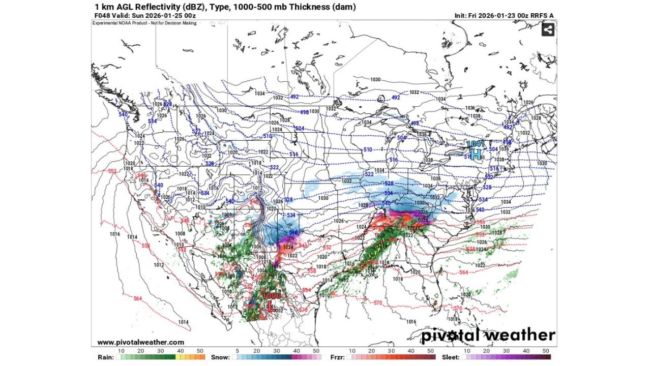
New RRFS-A Model Run Shows a Noticeable Storm Reduction
The 00z RRFS-A, initialized late Friday, shows a marked change compared to earlier forecasts. Reflectivity and thickness fields now depict a less expansive precipitation shield, with northern snow and ice bands retreating southward. Areas that previously appeared locked into prolonged wintry precipitation now sit beneath drier air and stronger surface high pressure, limiting cold-air availability.
This shift is clearly visible in the 1000–500 mb thickness lines, which have trended higher across much of the Great Lakes, Ohio Valley, and interior Northeast, signaling a reduced risk for widespread frozen precipitation in those regions.
Remaining Winter Threat Focused on the Southern Tier
While the storm has weakened overall, it has not disappeared. The latest data still supports a narrow but impactful corridor of wintry weather stretching from parts of Texas and the southern Plains, eastward through portions of the Tennessee Valley and southern Appalachians.
Within this zone, freezing rain, sleet, and wet snow remain possible as warm air overruns shallow surface-level cold air. However, even in these areas, the storm now appears more progressive and less intense, reducing the likelihood of long-duration ice accumulation compared to earlier forecasts.
Why the Storm Lost Strength
Meteorologists point to several key atmospheric changes contributing to the storm’s downgrade:
- Stronger high pressure over the northern United States, limiting cold-air supply
- A weaker upper-level trough, reducing lift and precipitation efficiency
- Faster eastward progression, shortening the duration of wintry precipitation
- Improved alignment of warmer mid-level air, favoring rain over ice or snow in some regions
These factors combined to “take a bite” out of the storm, dramatically shrinking its spatial coverage.
Impacts Still Possible Despite the Weaker Signal
Even with the reduced footprint, localized impacts remain possible, particularly where freezing rain overlaps with marginal surface temperatures. Light to moderate icing could still create slick travel conditions, especially during nighttime and early morning hours when road temperatures drop fastest.
Additionally, areas that experience rapid transitions between rain, sleet, and snow may still see brief but hazardous conditions, even if accumulations remain lower than initially feared.
Forecast Confidence Improving, but Uncertainty Remains
The RRFS-A model is experimental and designed to capture fine-scale details, meaning additional adjustments remain possible as newer runs come in. Small shifts in temperature profiles could still re-expand or further suppress remaining ice and snow zones.
Forecasters stress that while the worst-case scenario appears less likely, residents across the southern and central U.S. should continue monitoring updates through the weekend, especially in regions still near the freezing line.
As updated guidance continues to refine the storm’s evolution, this developing situation highlights how quickly winter forecasts can change. For continued weather analysis, storm trend updates, and regional impact breakdowns, visit ChicagoMusicGuide.com for the latest coverage.