
SPC Upgrades Monday’s Risk to Enhanced Level Across the Upper Midwest as Large Hail, Damaging Winds and a Significant Tornado Threat Target Minnesota, Wisconsin, Iowa and Northern Illinois
MINNEAPOLIS, MN — The Storm Prediction Center has officially upgraded Monday’s severe weather risk to a Level 3 Enhanced Risk across parts of the Upper Midwest, and the outlook maps issued Sunday afternoon make clear that this is not a routine spring storm event. Minnesota, Wisconsin, Iowa, and northern Illinois are all inside a multi-threat severe weather corridor that becomes active Monday, with large hail as the primary driver of the upgrade but a significant tornado threat waiting in the wings if storms can organize on the warm side of an approaching warm front.
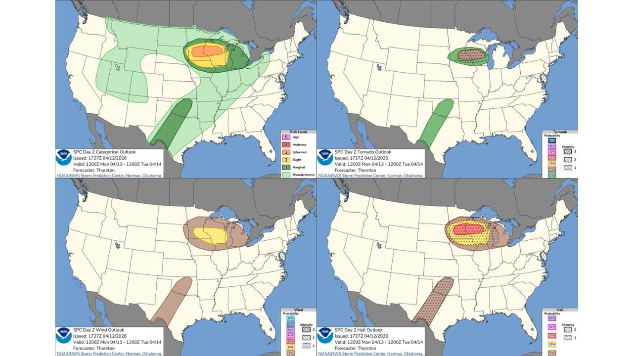
The outlook is valid from Monday, April 13 through Tuesday, April 14, 2026.
What the Upgraded Outlook Shows
The SPC Day 2 Categorical Outlook places an Enhanced Risk — Level 3 of 5 — across the core of the Upper Midwest, centered over Minnesota, Wisconsin, and Iowa. Inside that Enhanced zone sits a Moderate Risk — Level 4 of 5 — covering the highest-threat corridor, which appears centered over southern Minnesota through central Wisconsin. A Slight Risk surrounds the Enhanced zone, extending the threat into northern Illinois, Michigan, and portions of the Great Lakes. A Marginal Risk reaches outward to include Nebraska, Missouri, and the broader Midwest fringe.
A secondary and separate area of thunderstorm activity is also indicated on the outlook across a narrow corridor stretching from Texas through the lower Mississippi Valley, though this zone carries a lower risk designation than the primary Upper Midwest target.
Threat-by-Threat Breakdown
Hail — The Primary Threat Driver
The hail outlook for Monday is the most clearly defined and highest-probability threat in this entire event. The SPC Day 2 Hail Outlook shows a 30% or greater hail probability — depicted in yellow hatching — across Minnesota, Wisconsin, and Iowa, with a 45% or greater probability core in red covering the highest-risk zone over southern Minnesota and central Wisconsin. Hatching on SPC hail maps indicates the additional threat of significant hail — stones two inches or larger in diameter. Two-inch hail is roughly the size of a golf ball and causes severe vehicle damage, roof destruction, and serious injury risk to anyone outdoors.
Wind — Significant Damaging Gusts
The SPC Day 2 Wind Outlook shows a 30% or greater damaging wind probability across Iowa and Wisconsin, with a 45% probability core over the same southern Minnesota and Wisconsin corridor that carries the highest hail risk. Wind gusts capable of downing power lines, snapping trees, and causing structural damage are expected with the most organized storm cells Monday.
Tornadoes — Conditional but Significant Ceiling
The tornado outlook is the most critical watch item for Monday. The SPC Day 2 Tornado Outlook shows a 10% or greater tornado probability with hatching — indicating significant tornado potential — across the core zone covering southern Minnesota through central Wisconsin. The hatching designation means forecasters cannot rule out EF-2 or stronger tornadoes within this corridor. A broader 5% probability zone extends the tornado threat across Iowa and northern Illinois. The key condition: a significant tornado threat materializes if storms can develop and sustain themselves on the warm side of the warm front pushing through the region Monday.
Complete Monday Outlook Data Table
| Threat | Probability | Significant Threshold | Core Zone |
|---|---|---|---|
| Hail | 45%+ core, 30%+ broad zone | Yes — 2 inch or larger hail | Southern MN, Central WI |
| Wind | 45%+ core, 30%+ broad zone | Damaging gusts | Iowa, Wisconsin corridor |
| Tornado | 10%+ with hatching | Yes — EF-2+ possible | Southern MN, Central WI |
| Overall Risk | Enhanced Level 3 | Moderate Level 4 core | MN, WI, Iowa |
State-by-State Breakdown for Monday
Minnesota — Southern and Central The highest-risk state in Monday’s outlook. The Moderate Risk core is centered here, and all three severe weather maps — hail, wind, and tornado — place their highest probability values over southern and central Minnesota. The hatched significant tornado zone covers this corridor directly. Residents across Minneapolis, Saint Cloud, Mankato, Rochester, Willmar, and surrounding communities face the most dangerous combination of threats on Monday. Shelter plans must be confirmed before afternoon storm development begins.
Wisconsin — Central and Southern Wisconsin shares the highest-risk designation with Minnesota across all three threat maps. Eau Claire, Wausau, Green Bay, Madison, and Milwaukee all fall within the Enhanced to Moderate risk corridor. The significant hail and significant tornado hatching extends across central Wisconsin, meaning EF-2 or stronger tornadoes and golf-ball-or-larger hail are both within the realm of possibility here Monday.
Iowa — Statewide Iowa falls inside the Enhanced Risk zone on the categorical outlook and carries 30% or greater probability on both the hail and wind maps. A 5% tornado probability covers the state. Des Moines, Cedar Rapids, Waterloo, Dubuque, and Sioux City are all within the active severe weather corridor for Monday. Large hail and damaging winds are the primary Iowa threats, with tornadoes possible particularly across northern Iowa closer to the warm front boundary.
Illinois — Northern Counties Including Chicago Northern Illinois including the Chicago metro sits inside the Slight Risk zone on the categorical outlook with measurable tornado and hail probabilities. The threat here is lower than in Minnesota and Wisconsin but not dismissible — organized severe thunderstorms capable of producing large hail and damaging winds will be possible across northern Illinois Monday, with an isolated tornado possible if the warm front pushes far enough south.
Michigan — Western Western Michigan falls within the Slight Risk zone and the outer edges of the hail and wind probability fields. Severe thunderstorms are possible here Monday, primarily during the evening hours as the system tracks eastward.
Forecast Confidence
Forecast Confidence: Moderate to High. The SPC upgrade to Enhanced Risk with a Moderate Risk core over southern Minnesota and Wisconsin reflects strong institutional confidence in a significant severe weather event Monday. The hail threat is the most certain element — large and potentially significant hail is well-supported across the Minnesota and Wisconsin corridor. The tornado threat carries more uncertainty tied to warm front positioning and storm mode, but the significant tornado hatching on the outlook means forecasters are treating that ceiling as a real and credible outcome.
All residents across Minnesota, Wisconsin, Iowa, and northern Illinois should have shelter plans confirmed, weather alert devices active, and outdoor activities wrapped up before Monday afternoon storm development begins.
More severe weather upgrade coverage is always on the horizon. Stay informed at ChicagoMusicGuide.com — your source for Enhanced Risk and tornado outbreak tracking across Minnesota, Wisconsin, Iowa, Illinois, and the entire United States.