
St. Louis, Columbia, Quincy and Springfield Brace for Rapid Storm Development as Warm Front Ignites Severe Weather Across Missouri and Illinois
ST. LOUIS, MISSOURI — A rapidly evolving severe weather setup is taking shape across Missouri and Illinois as storms begin to bubble and intensify along a highly unstable warm frontal boundary. Key cities including St. Louis, Columbia, Quincy, Springfield, and Macomb are now entering a window where storm development could quickly become more robust within the next hour.
Warm Front and Surface Low Creating a Volatile Storm Environment
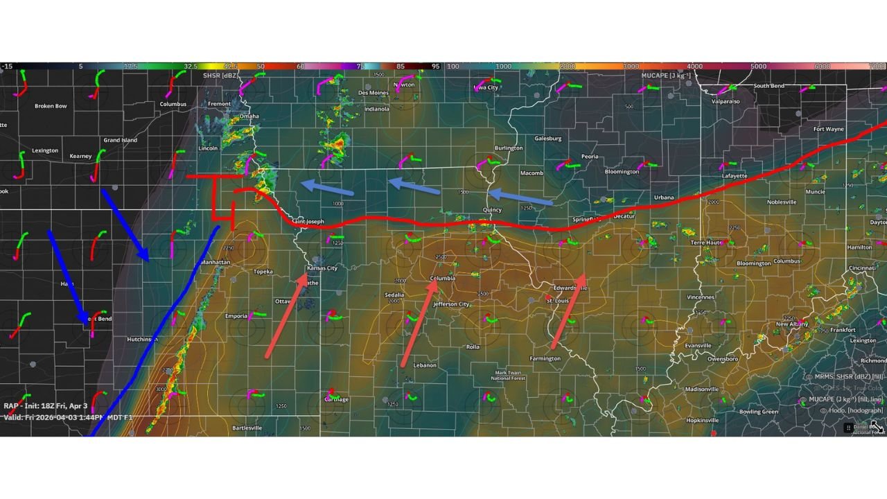
The current setup is being driven by a strengthening surface low positioned across northeast Kansas and northern Missouri, with a warm front extending eastward into Illinois. This boundary is acting as a trigger zone where storms are beginning to form and organize more efficiently.
Atmospheric data shows strong wind shear aligned along the warm front, combined with increasing instability south of the boundary. This combination is ideal for storm intensification, particularly in areas directly under or just north of the surface low.
Cities such as Columbia, Jefferson City, and St. Louis are positioned in a favorable zone where rising air and moisture convergence are supporting early storm growth. As this system continues to evolve, storms forming along this boundary could rapidly strengthen.
Two Key Severe Weather Corridors Emerging
Analysis of the setup highlights two primary areas of concern for storm development:
The first zone is located underneath the surface low across northeast Kansas into northern Missouri, including areas near Kansas City and St. Joseph. This region is already seeing initial storm formation, and these storms could expand or merge as they track eastward.
The second, and potentially more concerning zone, stretches from northeast Missouri into west-central Illinois, impacting cities like Quincy, Macomb, Peoria, and Springfield. This corridor is expected to see more organized storm development as the evening progresses, especially as atmospheric conditions continue to improve.
This dual-zone setup increases the likelihood of multiple storm clusters forming simultaneously, which could lead to rapidly changing conditions across both states.
Storm Development Expected to Intensify Quickly
Current observations suggest that the first storm of interest has already developed directly along the warm front beneath the surface low. Additional storms are expected to form and strengthen quickly over the next hour, particularly in areas where wind shear and instability overlap.
Forecast soundings from the region indicate a supportive environment for strong updrafts and rotating storms, especially across northeast Missouri into Illinois. This raises concerns for localized severe weather, including:
- Strong wind gusts
- Frequent lightning and heavy rainfall
- Potential for isolated severe storm structures
As storms mature, interactions between cells could further enhance their intensity, especially along the warm frontal boundary where conditions are most favorable.
What Residents Across Missouri and Illinois Should Watch For
Residents across St. Louis, Columbia, Quincy, Springfield, and surrounding areas should closely monitor conditions as storms begin to expand in coverage and intensity through the evening hours.
The environment suggests that storms could quickly transition from isolated development to more widespread activity, particularly along the Missouri–Illinois corridor. Timing will be critical, as storm intensity may increase rapidly within a short window.
Those in affected areas should be prepared for quick weather changes, especially during the early evening period when atmospheric conditions are expected to peak.
For the latest severe weather updates, storm tracking, and regional coverage, visit ChicagoMusicGuide.com and stay informed as this developing situation unfolds.