
Storm Line Strengthens From Kansas Through Oklahoma Into Missouri Overnight as Cold Front Pushes Southeast With Damaging Wind Threat
WICHITA, KANSAS — Meteorologists tracking severe weather across the Central Plains and Ozarks region say the expected supercell outbreak has evolved into a more complex storm system, with a growing line of thunderstorms stretching from eastern Kansas through Oklahoma and into Missouri. While earlier forecasts highlighted the potential for isolated supercells and strong tornadoes, storm development has instead become more clustered and merged, reducing the likelihood of widespread discrete tornado-producing storms.
However, forecasters emphasize that severe weather remains ongoing, particularly as a cold front continues pushing southeastward across the region. The main threat overnight is expected to shift toward damaging straight-line winds, though embedded tornadoes within the storm line remain possible as the system continues to organize.
Storms Merge Across Kansas and Oklahoma, Limiting Discrete Supercells
Radar imagery shows numerous thunderstorms forming earlier across Kansas and Oklahoma, but many of these storms struggled to fully organize into classic surface-based supercells. Instead, storms frequently merged together, creating clusters and broken lines of thunderstorms.
Meteorologists say this merging behavior is common when storms form close together in environments where surface instability and storm spacing are not ideal for sustained supercell development. Across Kansas, several storm cells had difficulty anchoring to the surface layer, limiting their ability to maintain strong rotation.
Despite these challenges, a few tornadoes were reported earlier across Oklahoma, where storms briefly organized enough to produce localized rotation before merging with nearby thunderstorms.
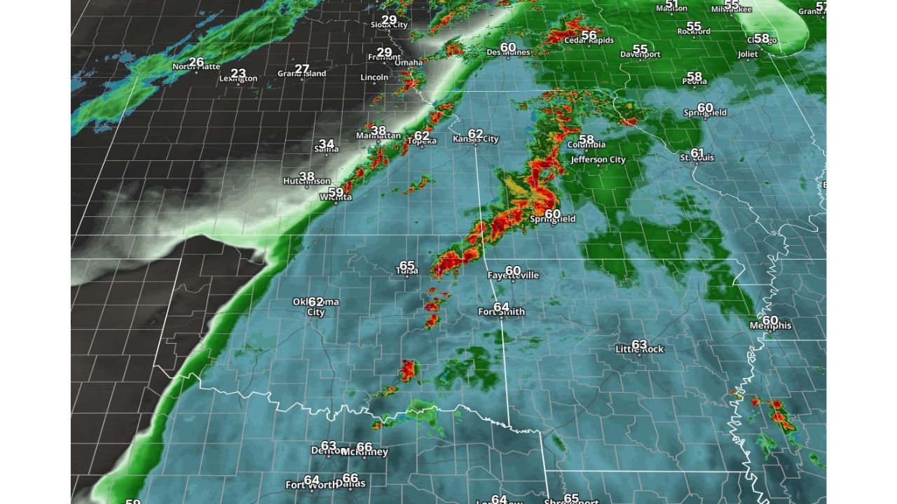
Cold Front Driving Expanding Line of Thunderstorms
The current radar pattern shows a developing line of storms extending from eastern Kansas near Topeka and Kansas City southward through Tulsa and into northwest Arkansas, including areas near Springfield, Missouri and Fayetteville, Arkansas.
This line of storms is forming along a cold front advancing southeastward across the Plains, which is forcing warm and moist air upward and allowing thunderstorms to organize into a broader system.
Communities including Wichita, Topeka, Kansas City, Tulsa, Springfield, and Fort Smith may see storms continue to move through overnight as the front progresses deeper into the Ozarks and Mid-South region.
Damaging Wind Threat Increasing Overnight
As the storm system consolidates into a larger line, meteorologists say the primary severe weather threat is shifting toward damaging winds. When thunderstorms organize into a squall line along a cold front, they often produce strong straight-line winds capable of causing power outages and tree damage.
Embedded rotations within the line can occasionally produce brief tornadoes, though these events tend to be shorter-lived and harder to detect than tornadoes produced by isolated supercells.
Forecasters are continuing to monitor the storm system as it pushes toward Missouri, Arkansas, and eventually the Mississippi Valley overnight into early morning.
Although the earlier potential for strong isolated tornadoes appears to have decreased, meteorologists emphasize that severe weather hazards remain possible, especially for communities directly along the advancing storm line.
Residents across Kansas, Oklahoma, Missouri, and Arkansas are encouraged to remain weather aware overnight and ensure they have multiple ways to receive weather alerts before going to sleep.
As the cold front continues moving southeast and the storm system evolves, additional updates on severe weather conditions across the region will be issued. For continuing coverage of major storms and weather developments across the United States, visit ChicagoMusicGuide.com.