
Storm Threat Building Across Ohio, Kentucky, and Western Pennsylvania Saturday as HRRR Rotation Tracks Highlight Areas Southeast of I-71
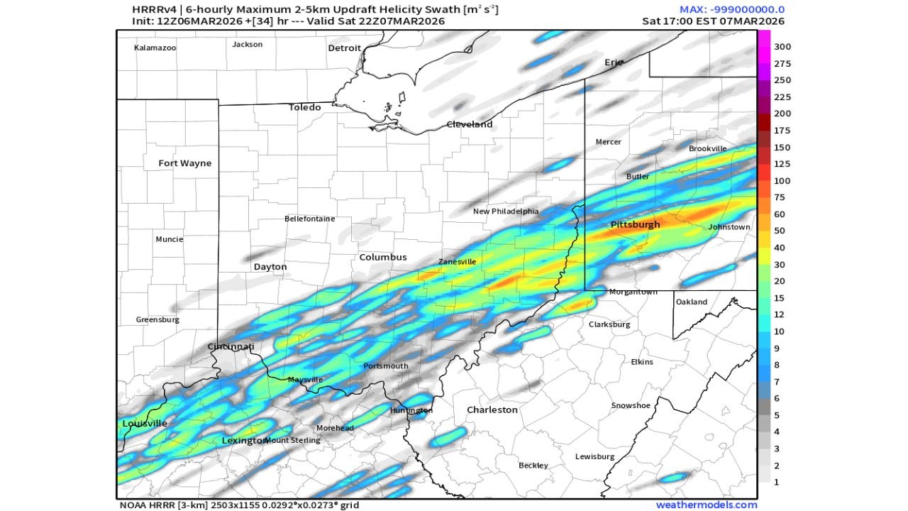
COLUMBUS, OHIO — Meteorologists analyzing the latest 12z HRRR weather model guidance say the highest severe weather risk on Saturday appears to be focused across southeastern Ohio, northern Kentucky, and western Pennsylvania, particularly areas southeast of Interstate 71. The model’s rotation track analysis, which highlights zones where rotating thunderstorms could develop, shows a concentrated corridor stretching from Louisville and Lexington through southern Ohio and into Pittsburgh and western Pennsylvania.
The analysis suggests that communities along this corridor could see the strongest thunderstorms of the day, especially during the late afternoon and early evening hours on Saturday as atmospheric instability and wind shear increase across the Ohio Valley region.
HRRR Model Shows Rotating Storm Corridor From Kentucky Through Ohio Into Pennsylvania
Weather model graphics displaying 6-hour maximum updraft helicity swaths indicate a long band of potential rotating storms extending from central Kentucky through southern Ohio and into western Pennsylvania.
The corridor begins near Louisville and Lexington in Kentucky, then stretches northeastward through Maysville, Portsmouth, and Zanesville in Ohio, eventually reaching Pittsburgh and Johnstown in Pennsylvania. This type of model output often highlights areas where supercells or rotating thunderstorms may track over several hours.
The most intense signals in the model appear near southeastern Ohio and southwestern Pennsylvania, suggesting storms could strengthen as they move along the Ohio River Valley corridor toward the Appalachian foothills.
Meteorologists note that updraft helicity tracks are commonly used to identify potential storm rotation, which can indicate a higher likelihood for severe thunderstorms capable of damaging winds, hail, or isolated tornadoes.
Areas Southeast of Interstate 71 Face the Highest Severe Weather Potential
Forecast discussions emphasize that the greatest severe weather risk appears southeast of Interstate 71, which runs through Cleveland, Columbus, and Cincinnati in Ohio.
Cities located south and east of that interstate corridor—including Portsmouth, Zanesville, Athens, and surrounding Ohio Valley communities—may sit closer to the environment most favorable for storm rotation. The model projections also extend that risk zone into northern Kentucky and western Pennsylvania, including areas near Pittsburgh, Butler, and Johnstown.
Meanwhile, locations northwest of Interstate 71, including parts of northwest Ohio and northern Indiana, appear to remain outside the main corridor of stronger storm rotation signals according to the current model guidance.
However, meteorologists caution that forecast models can shift slightly as new data arrives, meaning the exact storm track could adjust before Saturday afternoon.
Storm Development Expected Saturday Afternoon and Evening
Forecasters say the most active storm period will likely occur between late afternoon and early evening Saturday, when atmospheric conditions become more supportive of severe weather across the Ohio Valley.
Warm and moist air moving northward from the Tennessee Valley and Kentucky will interact with stronger winds higher in the atmosphere, creating the type of environment that can support organized thunderstorms and rotating storm structures.
If storms develop along the projected corridor, they may travel northeast from Kentucky through Ohio and into Pennsylvania, potentially impacting several major population centers during the evening hours.
Meteorologists emphasize that exact storm timing and intensity will become clearer as the event approaches, but current data suggests residents across southeastern Ohio, northern Kentucky, and western Pennsylvania should closely monitor weather updates as the situation evolves.
As forecasters continue analyzing new model runs and atmospheric data ahead of Saturday’s storm potential, updated forecasts and safety information will be issued throughout the region. For continuing coverage of developing weather systems and severe storm risks across the United States, visit ChicagoMusicGuide.com.