
Strong Thunderstorms Weaken Across Lexington, Louisville and Cincinnati as Late-Night Storm Line Fails to Reach Severe Levels in Kentucky
LEXINGTON, KENTUCKY — A line of strong thunderstorms that swept across parts of Kentucky late Saturday night into early Sunday morning ultimately failed to reach severe levels, easing concerns across Lexington, Louisville, and surrounding communities.
As of the 12:30 a.m. Eastern radar update, meteorologists indicated this would likely be the final update for the event, noting the line had produced periods of heavy rain and lightning but continued to weaken as it pushed eastward.
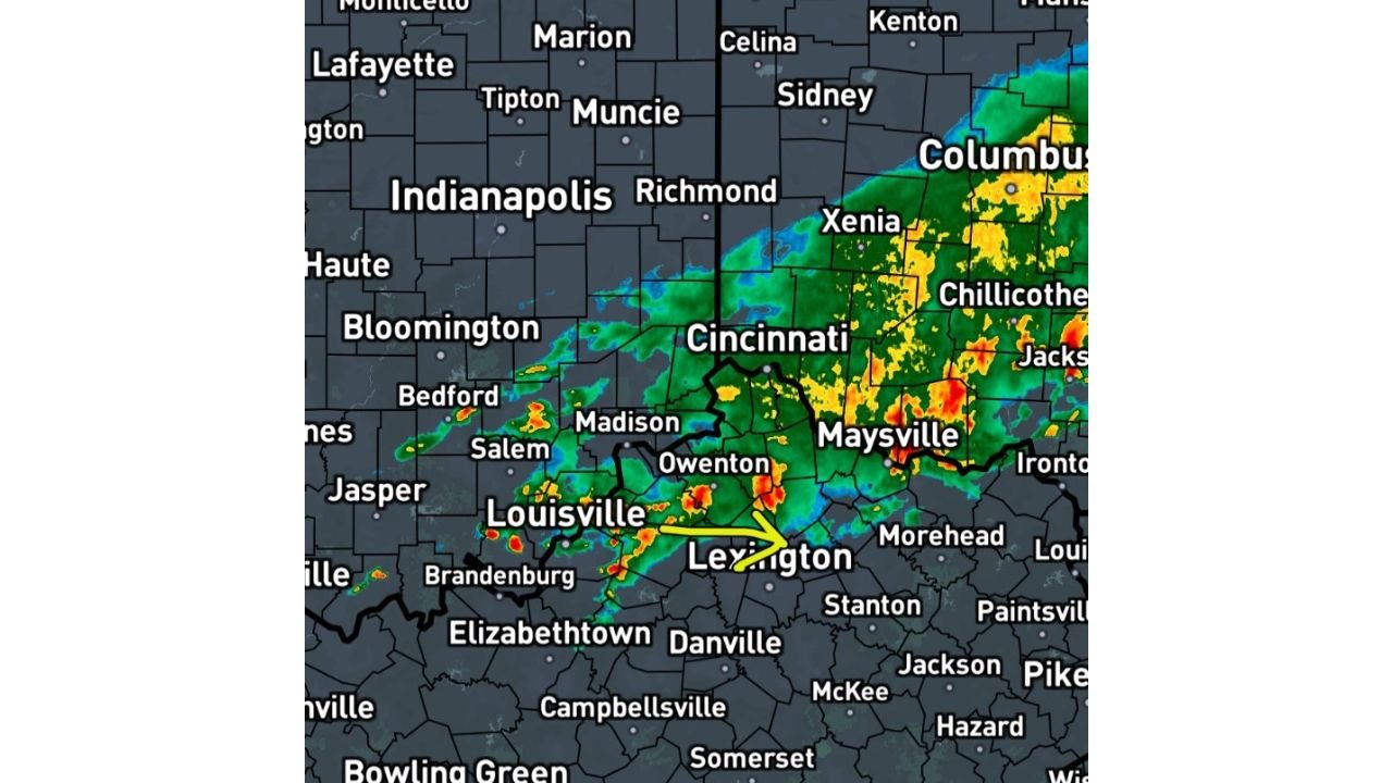
Storm Line Tracks Across Northern and Central Kentucky
Radar imagery showed the main band of storms stretching from near Cincinnati, Ohio, southwest through Louisville, Kentucky, and east toward Lexington and Maysville.
Communities in the path included:
- Louisville
- Lexington
- Owensboro (nearby regions west)
- Madison
- Maysville
- Cincinnati
- Xenia and Columbus, Ohio (north of the main Kentucky focus)
Earlier expectations suggested the system could produce more widespread severe weather. However, while storms were locally strong, they did not intensify to officially severe criteria.
Heavy Rain and Lightning, But No Widespread Severe Reports
The radar presentation showed embedded pockets of heavier rainfall near:
- Lexington
- Owensboro
- Madison
- Areas southeast of Louisville
Despite bursts of heavier precipitation and gusty winds, the line weakened steadily as it progressed east.
Forecasters had previously cautioned that this system might “sound more rowdy” than it would ultimately become — and that assessment proved accurate. The atmospheric setup did not provide enough sustained instability for widespread severe storm development.
Event Winds Down After Midnight
By shortly after midnight, the storm line was losing organization across central and eastern Kentucky.
The message to residents was reassuring: no life-threatening conditions were unfolding, and the overall threat level diminished as the system weakened.
The heaviest rain shifted east of Lexington toward northeastern Kentucky while central portions of the state saw improving conditions.
Calm Returns to Kentucky
With the strongest activity fading and no severe warnings ongoing across much of the region, the late-night hours brought a return to calmer weather for central Kentucky.
While scattered showers lingered in spots, the primary convective threat had ended.
For ongoing updates on weather systems moving across the Midwest and Ohio Valley, stay with ChicagoMusicGuide.com.