
Strong to Severe Storms Possible Across Texas, Louisiana, Mississippi, Alabama, Tennessee, Kentucky, and Ohio as Gulf Moisture and Powerful Upper Trough Align Friday
UNITED STATES — Forecast guidance from both the EURO (ECMWF) and GFS models indicates a potentially active severe weather setup developing Friday, stretching from the Deep South into the Ohio Valley, as a large upper-level trough moves east and the Gulf of Mexico opens fully for moisture return.
Meteorologists are closely watching this system due to the combination of strong wind shear, increasing low-level moisture, and a broad warm sector, which together support strong to severe thunderstorms across multiple states.
Large Upper Trough Drives Widespread Wind Shear
Model guidance shows a powerful mid- and upper-level jet streak carving across the southern and central United States. The 500 mb and 850 mb wind fields depict strong southwesterly flow from Texas through the Tennessee and Ohio Valleys, creating favorable vertical wind shear for organized storms.
This setup supports storm organization, including the potential for rotating thunderstorms, especially where surface-based storms can develop.
Gulf Moisture Return Fuels the Warm Sector
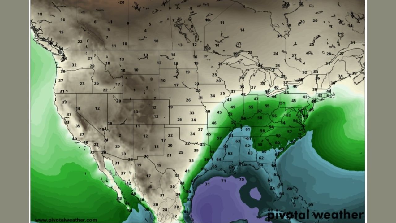
Dew point projections clearly show rich Gulf moisture surging northward, with 50s to low 60s dew points pushing into:
- Texas
- Louisiana
- Mississippi
- Alabama
- Tennessee
- Kentucky
- Portions of the Ohio Valley
This moisture return expands the warm sector northward, increasing the area where thunderstorms can intensify ahead of the approaching cold front and surface low.
CAPE Remains Limited but Not Zero
While instability (CAPE) is not extreme, model data shows just enough instability overlapping with strong shear to support isolated severe storms. This means:
- Storm coverage may be scattered
- But any storm that becomes surface-based could turn severe quickly
The main limiting factor remains drier air intrusion from the west, which may cap storm coverage in some areas. However, where moisture wins out, storms could intensify rapidly.
Primary Risk Areas Based on Current Data
Based strictly on current model consensus, the highest concern corridor includes:
- Eastern Texas
- Louisiana
- Mississippi
- Alabama
- Western and Middle Tennessee
- Kentucky
- Southern Ohio Valley
These areas sit closest to the best overlap of shear, moisture, and lift.
Potential Threats
If storms fully develop, the main threats include:
- Damaging straight-line winds
- Isolated tornadoes
- Heavy rainfall in stronger cells
- Frequent lightning
Because the setup favors isolated but intense storms, impacts may be localized but significant.
Forecast Confidence Still Evolving
While confidence is growing, forecasters note that small shifts in moisture or dry air placement could significantly change where storms form. This makes continued monitoring critical over the next 24–48 hours.
Residents across the Deep South and Ohio Valley should stay alert for updated outlooks, watches, and warnings as the system approaches.
Stay weather-aware and keep checking updates as this late-week storm system evolves. What are you seeing in your area? Share your local conditions and follow ChicagoMusicGuide.com for continued severe weather updates.