
Stronger Cold Front Targets Memphis, Charlotte, Raleigh and Norfolk Monday as Severe Storm Threat Expands from Tennessee to the Carolinas and Coastal Virginia
MEMPHIS, TENNESSEE — A more potent cold front is now in focus for Monday, and early forecast data suggests this system could pack a stronger punch than the one currently moving through parts of the South.
Meteorologists are watching a developing setup that could bring a renewed round of strong to severe thunderstorms from the Mid-South into the Carolinas and coastal Virginia as the front pushes eastward.
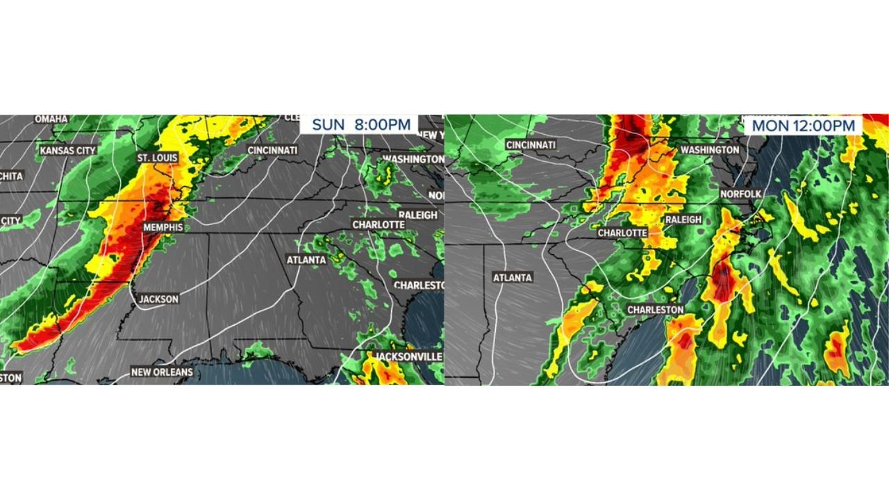
Sunday Evening: Line of Storms Across the Mid-South
By Sunday evening around 8 p.m., forecast guidance shows a pronounced line of thunderstorms stretching from near Houston northeast through Jackson and into Memphis, with heavier rain and embedded stronger cells along the leading edge.
Areas near:
- Memphis
- Jackson, Mississippi
- Portions of eastern Arkansas
- Northern Louisiana
appear positioned within a corridor of stronger activity Sunday night.
While Sunday’s threat appears organized, attention is quickly shifting to what unfolds Monday as the system intensifies and moves east.
Monday Midday: Strong Line Advances Into the Carolinas and Virginia
By Monday around midday, the front is projected to extend from the Ohio Valley southward through the Carolinas.
Storm clusters and a developing line appear near:
- Charlotte
- Raleigh
- Charleston
- Norfolk
- Washington, D.C.
The forecast highlights a broad severe weather risk zone stretching from coastal South Carolina and North Carolina northward into eastern Virginia.
Why Monday Looks More Concerning
Forecast discussions indicate that:
- The upper-level dynamics will be stronger than the current front.
- Wind energy aloft will increase as the trough sharpens.
- Timing of the frontal passage could align with daytime heating across parts of the Carolinas and Virginia.
If instability develops sufficiently ahead of the boundary, storms could strengthen quickly as they approach the I-95 corridor.
Primary threats would likely include:
- Damaging straight-line winds
- Embedded rotating cells
- Isolated tornado potential
The degree of severe weather will depend heavily on how much instability builds before the front arrives. A faster frontal passage could limit intensity, while a slower approach could allow storms to strengthen more substantially.
Coastal Impact Zone
The Monday severe risk area highlights:
- Charleston, South Carolina
- Charlotte, North Carolina
- Raleigh, North Carolina
- Norfolk, Virginia
- Portions of eastern North Carolina and southeastern Virginia
Coastal areas often experience enhanced wind profiles, which can support storm organization as lines move offshore.
Timing Will Be Crucial
Forecasters emphasize that exact timing remains key. Small shifts in when the front arrives could dramatically alter storm intensity.
Residents across Tennessee, Mississippi, the Carolinas, and Virginia should remain weather aware through the weekend as refinements continue.
For continued national severe weather coverage and storm analysis, stay with ChicagoMusicGuide.com.