
Subzero Wind Chills and Cold Weather Advisories Grip New York, New Jersey and Connecticut Overnight
UNITED STATES — Another dangerously cold night is unfolding across New York, New Jersey, and Connecticut, where wind chill values below 0°F are expected across much of the region. The National Weather Service has issued Cold Weather Advisories for the coldest areas, in effect from 1:00 a.m. to 10:00 a.m. Thursday, as Arctic air continues to dominate the Northeast.
Forecasters warn that the combination of single-digit temperatures and persistent winds will push “feels-like” temperatures to -5°F or lower in several inland and suburban locations, creating hazardous conditions for anyone outdoors overnight or early Thursday morning.
Cold Weather Advisories Issued for Interior and Suburban Areas
Cold Weather Advisories are in effect for portions of interior New York, northern and central New Jersey, and western Connecticut, where overnight conditions are expected to be most severe. Advisory areas include communities near Morristown, Newark, Paramus, White Plains, Poughkeepsie, Danbury, and Middletown, where prolonged exposure could quickly become dangerous.
The advisory window from 1 AM to 10 AM reflects the period when temperatures and wind chills are expected to be at their lowest, coinciding with the overnight minimums and early-morning commute hours.
Wind Chill Values Drop Well Below Zero Overnight
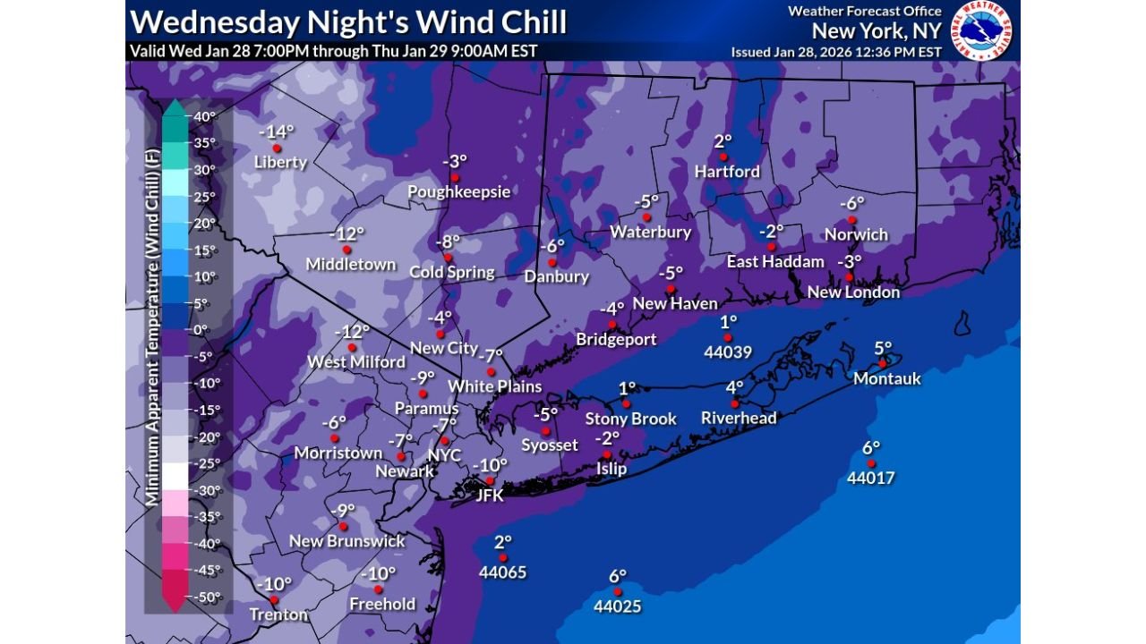
Forecast wind chill maps show widespread subzero values across much of the region. Inland locations across New Jersey and the Lower Hudson Valley are expected to experience wind chills ranging from -5°F to -12°F, with localized pockets dipping even lower in sheltered or elevated terrain.
Urban areas including New York City, Newark, and Bridgeport are not immune, with wind chills forecast in the -5°F to -10°F range overnight despite slightly higher air temperatures. Coastal areas and Long Island may see marginally higher readings, but still cold enough to pose health risks.
Single-Digit Temperatures Combine With Gusty Winds
Actual overnight temperatures are expected to fall into the single digits across much of the interior, with some locations approaching zero degrees before daybreak. When combined with steady northwest winds, the resulting wind chill values dramatically increase the danger level.
Even areas near the coast, including parts of Long Island and coastal Connecticut, will experience sharply colder conditions once winds increase overnight, eliminating much of the marine temperature moderation.
Health and Safety Risks Increase During Prolonged Cold
Meteorologists caution that frostbite can occur in as little as 20 to 30 minutes when wind chills fall below zero. Hypothermia risks also rise significantly during extended outdoor exposure, particularly for vulnerable populations such as the elderly, unhoused individuals, and those without adequate heating.
The extended duration of cold weather advisories signals that this is not a brief dip, but part of a continued Arctic pattern affecting the Northeast.
What Residents Should Do to Stay Safe
Officials urge residents across New York, New Jersey, and Connecticut to take precautions, including:
- Limiting time outdoors overnight and early morning
- Wearing layered, insulated clothing and covering exposed skin
- Checking on elderly neighbors and pets
- Protecting pipes and ensuring adequate indoor heating
- Using caution during early morning travel
With subzero wind chills expected to persist through the morning hours, preparation and awareness remain critical.
As this dangerous cold stretch continues across the Northeast, residents are urged to monitor local advisories and updated forecasts closely. For continued winter weather coverage, cold safety updates, and regional impact analysis, visit ChicagoMusicGuide.com.