
Tennessee, Virginia and the Mid-Atlantic in Focus as Sunday–Monday Storm Setup Hinges on High-Pressure Forcing and Coastal Transfer
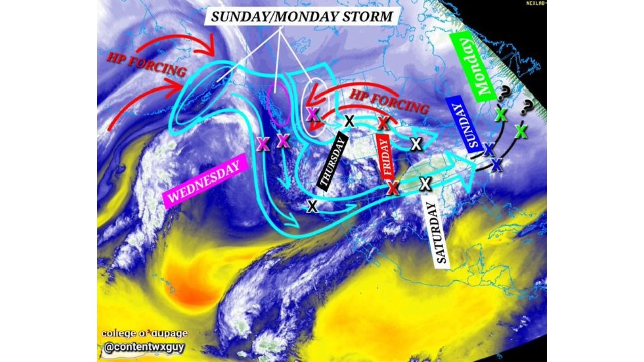
NASHVILLE, TENNESSEE — A complex Sunday–Monday storm system is beginning to take shape across the eastern United States, but forecasters say Thursday will be the key day to confidently assess impacts beyond Tennessee and the southern Appalachians. While confidence is growing in a storm developing somewhere east of the Mississippi River, the exact track and downstream snow potential across the Mid-Atlantic and Northeast remain uncertain.
Meteorologists emphasize that the atmospheric “players” are identifiable — but how they interact will determine who ultimately sees significant winter weather.
High-Pressure Forcing Will Steer the Storm
Satellite and upper-air analysis highlight a strong high-pressure forcing mechanism over central Canada and the northern Plains. This forcing is expected to push energy southeastward midweek before the system begins reorganizing.
The interaction between northern stream energy and southern moisture will dictate whether the storm consolidates efficiently as it moves east. Timing is critical: if phasing occurs properly, the system could intensify as it reaches the Tennessee Valley and Mid-Atlantic.
If the energy remains disorganized, impacts could be more limited or shifted farther offshore.
Tennessee as the Initial Battleground
As of now, forecasters caution against trusting precise outcomes north of Tennessee until at least Thursday afternoon. Tennessee sits near the initial transfer zone where low pressure may begin reorganizing before lifting toward the East Coast.
The position of the low-pressure center as it exits the Tennessee Valley will heavily influence snowfall prospects for Virginia, Maryland, Pennsylvania, New Jersey, and New York.
Even a modest deviation in the transfer point could shift the heaviest precipitation bands by hundreds of miles.
Mid-Atlantic and Northeast Still in Question
The storm’s evolution from Wednesday through Saturday shows multiple potential energy transfers before the Sunday–Monday window. If the final coastal low forms in an optimal position, snow could expand into portions of the Mid-Atlantic and New England.
However, forecasters are cautious about extending confidence north of Tennessee too soon. The pattern suggests possibility, but not certainty.
Key unknowns include:
- Where the low-pressure center transfers from inland to the coast
- Timing of upper-level forcing
- Strength of high-pressure influence
- Cold air positioning ahead of Sunday
Until those details become clearer, snowfall projections for cities like Richmond, Washington, D.C., Baltimore, Philadelphia, and New York City remain fluid.
Thursday: The Critical Assessment Day
Thursday is expected to provide clearer data regarding storm organization and downstream impacts. By then, higher-resolution model guidance should refine the low-pressure track and precipitation type distribution.
Forecasters describe the current stage as laying down logical guardrails rather than locking in snowfall totals.
In short, the setup supports a potentially impactful Sunday–Monday storm, but it remains in the “tracking phase.”
What to Watch Heading Into the Weekend
Residents across Tennessee, Virginia, Maryland, and the broader Mid-Atlantic should monitor updates as the week progresses. Once the storm moves within the 72-hour window, confidence in snowfall placement and intensity will increase significantly.
For now, the ingredients are visible — but the final recipe is not yet complete.
ChicagoMusicGuide.com will continue tracking this evolving winter system and provide updates as confidence builds. For detailed storm analysis and weekend forecast coverage, visit ChicagoMusicGuide.com.