
Texas and Midwest Brace for Explosive Storm Fuel as High CAPE Signals Tornado Risk from Texas to Illinois Tuesday
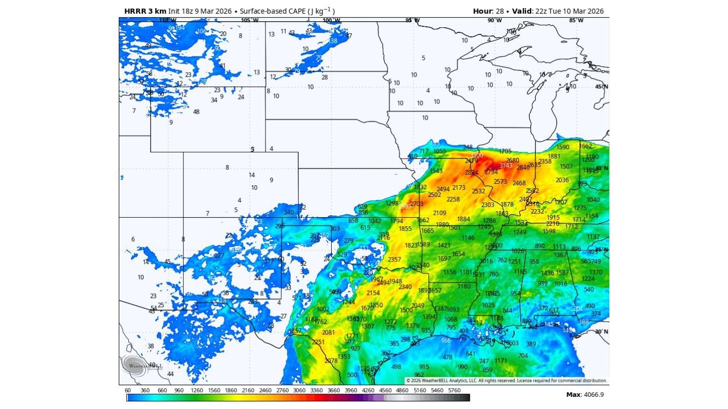
ILLINOIS — A powerful surge of atmospheric instability stretching from Texas through the Midwest and into Illinois is setting the stage for potentially explosive thunderstorm development Tuesday afternoon and evening. Forecast models show extremely high levels of surface-based CAPE (Convective Available Potential Energy) — the fuel storms need to grow rapidly — across Texas, Arkansas, Missouri, Illinois, Indiana, and parts of the Lower Midwest.
Meteorologists note that while the presence of storm fuel does not guarantee widespread tornadoes, the overlap of instability and wind shear could create conditions supportive of intense thunderstorms and possible tornado development, particularly across portions of the Midwest and parts of Texas.
Extreme CAPE Values Signal Strong Storm Potential
Forecast data valid Tuesday evening shows CAPE values exceeding 2,000 to 3,000 J/kg across large sections of Texas, Arkansas, Missouri, Illinois, Indiana, and western Kentucky. Some localized areas near the Missouri-Illinois border and into central Illinois show even higher pockets of instability approaching or exceeding 3,000 J/kg.
CAPE represents the energy available for rising air. The higher the value, the faster air can accelerate upward — allowing thunderstorms to grow taller and more powerful. With this much instability in place, any storm that develops could intensify quickly.
Across Texas, particularly north and east Texas, instability values are also robust, indicating that storms forming there could become strong early in the day before tracking northeast toward the Midwest.
This broad corridor of instability suggests a multi-state severe weather setup rather than an isolated local event.
Midwest Tornado Risk Focused Where Instability Overlaps Shear
While high CAPE alone does not guarantee tornadoes, the concern grows where instability overlaps with favorable wind patterns. Forecast discussions indicate that the greatest tornado risk may develop across parts of Missouri, Illinois, and Indiana, where storm fuel combines with strong wind shear.
Illinois, including areas near central and southern Illinois, sits within a zone of heightened instability Tuesday evening. If thunderstorms become surface-based and tap into this energy, supercell development becomes possible.
The same corridor of instability extending from eastern Texas through Arkansas and into Illinois highlights the potential for organized storm structures capable of producing:
- Large hail
- Damaging straight-line winds
- Isolated tornadoes
Storm intensity will largely depend on storm initiation timing and boundary interactions.
Texas Also Positioned for Early Severe Development
The CAPE map shows widespread instability across north and east Texas, with values commonly exceeding 1,500 to 2,500 J/kg. This suggests that storms forming across Texas could become strong during the afternoon before shifting east or northeast.
Because Texas sits at the southern end of the instability corridor, storms there may mature earlier in the day. As the system lifts toward the Midwest, it may encounter additional shear dynamics supportive of rotating storms.
The overlap between Texas and Midwest instability zones is significant, indicating this is a regional severe weather setup affecting multiple states rather than a single localized outbreak.
Illinois in the Crosshairs of Evening Storm Energy
By Tuesday evening, the instability axis stretches directly into Illinois, with strong CAPE values across central portions of the state. While northern Illinois appears less unstable compared to areas farther south, even moderate instability combined with strong wind fields could support severe weather.
If storms form along advancing boundaries or warm fronts pushing into Illinois, the state could see rapidly intensifying thunderstorms capable of large hail or isolated tornadoes.
The magnitude of instability shown in forecast models suggests storms that do develop will have no shortage of fuel. The key questions remain:
- Where will storms initiate?
- Will they become surface-based?
- How quickly will they organize?
These factors will determine whether Illinois experiences scattered severe storms or a more focused intense event.
Severe Weather Setup Spans Multiple States
From Texas through Arkansas, Missouri, Illinois, Indiana, and into the Lower Midwest, the atmospheric pattern reflects a classic spring-style severe weather configuration. Strong instability combined with favorable wind energy often produces organized storm clusters or supercells.
Even if tornado development remains isolated, the potential for large hail and damaging winds remains elevated across this entire corridor.
Residents across Texas and the Midwest, including Illinois, should monitor forecasts closely as Tuesday’s severe weather threat evolves throughout the afternoon and evening hours.
As instability peaks and storm boundaries become clearer, the focus areas for the highest risk will sharpen.
For continuing updates on Texas and Midwest severe weather threats, tornado risk zones, and Illinois storm developments, visit ChicagoMusicGuide.com for comprehensive weather coverage.