
Texas and Oklahoma Face January Marginal Severe Storm Risk as Transition-Zone Thunderstorms Develop
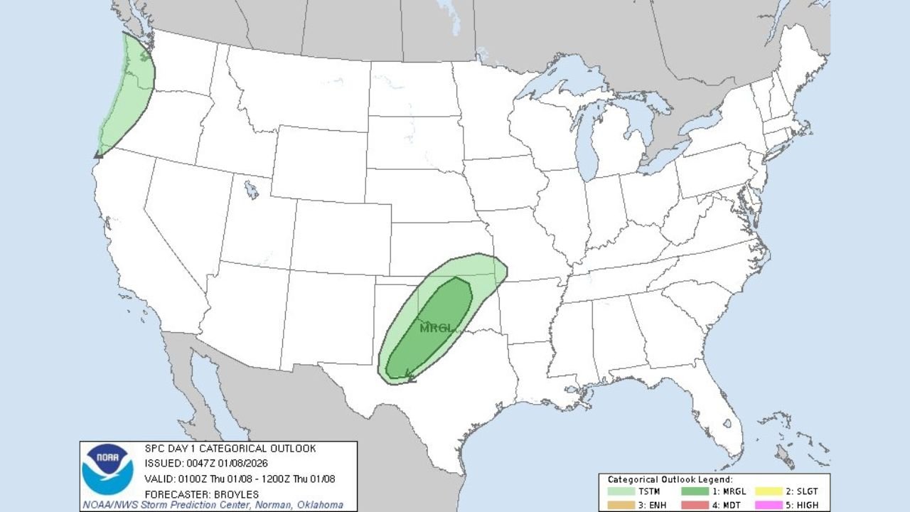
TEXAS – A Day 1 Marginal Risk for severe weather has been issued by the Storm Prediction Center for parts of west and northwest Texas, extending into southwest and central Oklahoma, signaling a low-end but noteworthy severe setup as the broader winter pattern continues to shift across the central United States.
This setup is not a classic spring outbreak, but rather a transition-zone event, where lingering winter air meets a modest surge of warmer, unstable air. These types of patterns often produce isolated strong storms that can still surprise, especially in January.
What the Marginal Risk Means for Texas and Oklahoma
The highlighted area on the SPC map shows a Marginal Risk (Level 1 of 5), which typically means:
- Isolated strong thunderstorms
- A limited severe threat, but not zero
- Potential for gusty winds and small hail
- A very low tornado risk, but not impossible
This risk zone arcs from west and northwest Texas into southwest and central Oklahoma, following a corridor where atmospheric energy briefly overlaps.
Why This Is Happening Now
This setup is being driven by a split-flow jet stream, with:
- A northern stream supplying cooler air
- A southern stream disturbance providing lift and moisture
The overlap of these two features creates a narrow window where storms can organize before the atmosphere stabilizes again. Because instability is limited, storms are expected to remain scattered and short-lived, but a few could briefly intensify.
This pattern also ties into a broader Ohio Valley transition zone, where winter air is gradually retreating north while southern systems attempt to push east.
Timing and Impacts to Watch
- Storms are most likely late evening into overnight
- Activity should remain spotty, not widespread
- Any stronger storm could produce brief wind damage or hail
- Many areas will see nothing at all, but awareness is key
Travel impacts are expected to be minimal, though sudden downpours or gusty winds could affect a few locations.
Bigger Picture: A January Pattern Shift
While this event is minor, it fits into a larger pattern change underway across the U.S.:
- Southern systems are becoming more active
- Cold air is no longer firmly locked in place
- Transition zones are increasing across the Plains and Ohio Valley
These ingredients don’t guarantee major storms, but they do raise the ceiling for future systems later in the month.
What to Do
- Stay weather-aware if you’re in west Texas or central Oklahoma
- Monitor local National Weather Service updates
- Don’t dismiss warnings just because it’s January
Even marginal setups can produce localized impacts.
If you enjoy clear, no-hype breakdowns of evolving weather patterns and how they connect across regions, keep following ChicagoMusicGuide.com for more updates and insight.