
Texas and Oklahoma Face Severe Storm Threat Wednesday with Golf Ball Size Hail, 60 MPH Winds, and Flooding Risk
TEXAS – Forecasters are warning of a severe weather outbreak Wednesday stretching from southern Oklahoma down through central and western Texas, bringing the potential for golf ball size hail, damaging 60 mph winds, and localized flooding through the evening and overnight hours.
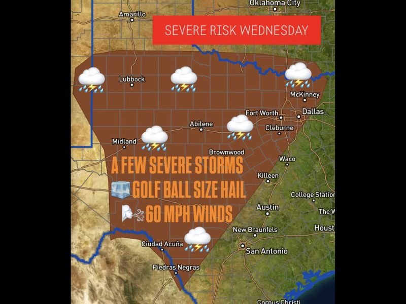
The Storm Prediction Center has outlined a large risk zone extending from Lubbock and Midland to Fort Worth, Brownwood, and Abilene, where a few strong to severe thunderstorms are expected to develop Wednesday afternoon and move east through the night.
Where the Greatest Threat Lies
The updated risk map highlights a wide swath of Texas shaded in dark brown — representing areas with the highest potential for severe storms.
Meteorologists say supercell thunderstorms could develop during peak heating hours Wednesday afternoon before organizing into clusters later in the evening. These storms will carry the threat of:
- Golf ball size hail capable of denting cars and damaging roofs
- 60 mph wind gusts that may down trees or power lines
- Heavy rainfall that could cause localized flash flooding, especially in low-lying areas
The storm zone includes Lubbock, Abilene, Brownwood, Fort Worth, and San Angelo, with severe weather also possible as far south as Austin and San Antonio and northward into southern Oklahoma.
“We’re looking at a classic setup for large hail and damaging winds,” one Texas meteorologist explained. “Even a single supercell could pack a serious punch if it holds together into the evening.”
Timing and Development
Storms are expected to fire up by mid-afternoon, initially across the western counties near Midland and San Angelo, before expanding eastward into the I-35 corridor by nightfall.
By late Wednesday evening, storms could merge into a larger line, producing widespread heavy rain and frequent lightning across central Texas. The flood threat will increase after sunset as storms repeatedly track over the same areas.
Forecasters note that severe weather watches may be issued as early as Wednesday afternoon once storms begin forming.
Flood Risk Adds Another Layer of Concern
In addition to the hail and wind threat, the latest guidance also points to a flood risk, especially where storms “train” over the same regions.
Rivers, creeks, and small streams could rise quickly overnight, and low-water crossings may become dangerous for drivers. Meteorologists warn that turning around at flooded roadways is the safest choice — as just a few inches of moving water can sweep a vehicle away.
Social Media Reactions Show Growing Concern
Texans across the affected region have already taken to social media to prepare. One Lubbock resident wrote:
“I just put the car in the garage — I’m not dealing with hail damage again.”
Another user from Abilene shared:
“Last time we had a storm like this, the wind took half my fence. Praying it’s not that bad tonight.”
Meanwhile, weather pages across Texas and Oklahoma have been flooded with radar graphics showing expanding storm cells and reminders to secure outdoor furniture, charge phones, and keep weather radios nearby.
What to Expect After the Storm
The front responsible for Wednesday’s storms is expected to drift east by Thursday morning, leaving behind cooler, drier air for the weekend. However, meteorologists caution that another system could develop early next week — meaning this brief calm may not last long.
What Do You Think?
Do you think these storms will be as intense as predicted, or will Texas dodge another major severe outbreak? Share your thoughts and follow live updates at chicagomusicguide.com.