
Texas Caprock Faces Dangerous Wintry Mix Overnight as Snow, Sleet, and Ice Worsen Road Conditions
LUBBOCK, TEXAS — A dangerous wintry mix of snow, sleet, and freezing rain continued across the Texas Caprock Friday night and is expected to persist through late night and into the early overnight hours, according to the National Weather Service in Lubbock. Radar data and forecaster analysis show precipitation remaining widespread, with road conditions deteriorating rapidly across multiple counties as temperatures remain below freezing.
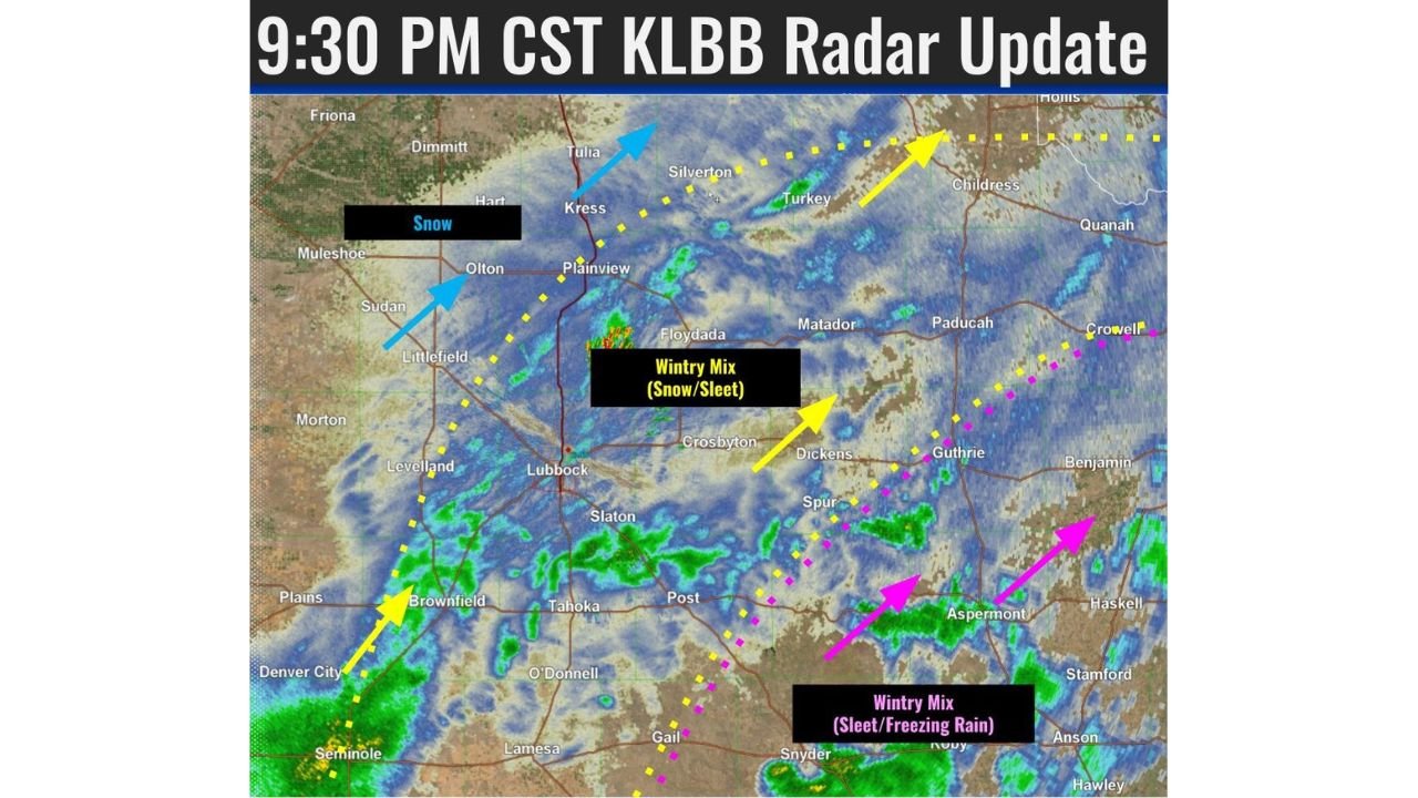
Wintry Precipitation Continues Across the Texas Caprock
The latest 9:30 PM CST KLBB radar update confirms that wintry precipitation remains ongoing off the Caprock and across much of the region. Light snow and sleet continue to fall intermittently, with coverage expected to remain steady through midnight and late tonight.
Forecasters note that snow and sleet are favoring the South Plains, while snow is more dominant across the southwestern Texas Panhandle. Meanwhile, areas farther southeast across the Rolling Plains are seeing a more hazardous combination of sleet and freezing rain, increasing the risk of ice accumulation on roads and elevated surfaces.
Road and Travel Conditions Rapidly Deteriorating
Officials warn that travel conditions are becoming increasingly dangerous as precipitation continues to fall on already cold surfaces. Even brief bursts of sleet or freezing rain can quickly glaze highways, overpasses, and secondary roads.
Drivers across Lubbock, Crosbyton, Plainview, Brownfield, and surrounding communities are urged to use extreme caution. Reduced visibility, slick pavement, and untreated rural roads pose a heightened risk for accidents overnight, especially as precipitation pulses continue on and off.
Radar Shows Multiple Wintry Zones Across the Region
Radar imagery highlights distinct precipitation types across the Caprock and nearby areas:
- Snow dominating portions of the western and northern Caprock
- Wintry mix (snow and sleet) extending eastward toward central counties
- Sleet and freezing rain intensifying across the southeastern Rolling Plains
This setup creates sharp gradients in road conditions, where driving conditions can worsen dramatically over short distances. Forecasters emphasize that even areas seeing lighter precipitation can experience sudden icing as surface temperatures remain well below freezing.
Cold Temperatures Reinforce Icing Threat
Adding to the danger, bitter cold temperatures are preventing any meaningful melting. Surfaces remain cold enough for precipitation to freeze on contact, allowing ice to accumulate despite relatively light precipitation rates.
The National Weather Service advises residents to stay indoors if possible, limit unnecessary travel, and continue monitoring local updates through the night as conditions evolve.
What Residents Should Do Overnight
Weather officials recommend several safety steps as wintry weather persists:
- Stay weather-aware and monitor official updates through the night
- Avoid travel unless absolutely necessary
- Slow down and increase following distance if driving
- Prepare for icy roads, especially bridges and overpasses
Conditions may remain hazardous until precipitation tapers off and temperatures begin to recover.
As Texas Caprock communities navigate this prolonged wintry event, staying informed and cautious will be key to avoiding dangerous situations overnight. For continued weather updates, radar analysis, and regional forecasts affecting Texas and beyond, visit ChicagoMusicGuide.com for the latest coverage.